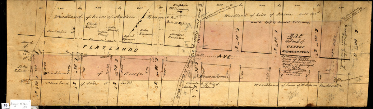
Map of woodland of George Kouwenhoven situated in the Town of Flatlands, and County of Kings: as surveyed Nov. 1876 by T.G. Bergen November 1876
Map No. Bergen-1876c.Fl
Cadastral map showing Flatlands Avenue between East 82nd Street and East 90th Street in modern-day Canarsie. Shows property and names of landowners. Ink, watercolor, and pencil, mounted on linen. Oriented with north to the upper right. Area covered identical to: Map of woodland of heirs of George Kouwenhoven, dec., situate[d] in Flatlands, Kings Co., N.Y., as surveyed Nov. 1876 / Teunis G. Bergen (Bergen-1876-1881.Fl ), also held by BHS.
Map area shown
Relation
Full catalog recordSize
18 × 62 cmDownload
Low Resolution Image
Creator
Bergen, Teunis G.,Publisher
Brooklyn Historical SocietyCitation
Map of woodland of George Kouwenhoven situated in the Town of Flatlands, and County of Kings: as surveyed Nov. 1876 by T.G. Bergen; November 1876, Map Collection, Bergen-1876c.Fl; Brooklyn Historical Society.Scale
Scale [1:2,400] 1 in to 2Loading zoom image...