Center for Brooklyn History
Map Collections
Search
About
Othmer Library & Archives
Submit search query
Refine 308 records
Clear filters
4
Location
Atlantic Basin (New York, N.Y.)
3
Bath Beach (New York, N.Y.)
8
Bay Ridge (New York, N.Y.)
108
Bay Ridge Park (New York, N.Y.)
1
Bedford-Stuyvesant (New York, N.Y.)
67
Bensonhurst (New York, N.Y.)
17
Boerum Hill (New York, N.Y.)
6
Borough Park (New York, N.Y.)
23
Brighton Beach (New York, N.Y.)
4
Brooklyn (New York, N.Y.)
891
Brooklyn Heights (New York, N.Y.)
76
Brownsville (New York, N.Y.)
10
Bushwick (New York, N.Y.)
20
Canarsie (New York, N.Y.)
18
Carroll Gardens (New York, N.Y.)
21
Clinton Hill (New York, N.Y.)
10
Cobble Hill (New York, N.Y.)
7
Coney Island (New York, N.Y.)
22
Cowenhoven Homestead (Brooklyn, New York, N.Y.)
1
Crown Heights (New York, N.Y.)
25
Cypress Hills (New York, N.Y.)
8
David Johnson Farm (New York, N.Y.)
1
Ditmas Park (New York, N.Y.)
1
Downtown Brooklyn (New York, N.Y.)
29
DUMBO Historic District (New York, N.Y.)
7
Dyker Heights (New York, N.Y.)
23
East Flatbush (New York, N.Y.)
23
East Midwood (New York, N.Y.)
1
East New York (New York, N.Y.)
16
Erasmus (New York, N.Y.)
1
Erie Basin (New York, N.Y.)
2
Farragut (New York, N.Y.)
1
Flatbush (New York, N.Y.)
35
Flatlands (New York, N.Y.)
19
Fort Greene (New York, N.Y.)
22
Fort Hamilton (New York, N.Y.)
31
Fulton Ferry Historic District (New York, N.Y.)
5
Futurama (New York, N.Y.)
2
Gowanus (New York, N.Y.)
12
Gowanus Canal (New York, N.Y.)
5
Gravesend (New York, N.Y.)
25
Green-Wood Cemetery (New York, N.Y.)
2
Greenpoint (New York, N.Y.)
38
Kensington (New York, N.Y.)
11
Kings County (New York, N.Y.)
8
Marine Park (New York, N.Y.)
5
Marway Farm (New York, N.Y.)
1
Midwood (New York, N.Y.)
9
New Lots (New York, N.Y.)
1
New Utrecht (New York, N.Y.)
9
New York (N.Y.)
164
New York (State)
95
New York Metropolitan Area
40
Nottingham (New York, N.Y.)
2
Park Slope (New York, N.Y.)
16
Parkville (New York, N.Y.)
2
Pierrepont Homestead (New York, N.Y.)
6
Prospect Heights (New York, N.Y.)
16
Prospect Lefferts Gardens (Brooklyn, New York, N.Y.)
16
Prospect Park (New York, N.Y.)
25
Prospect Park South (New York, N.Y.)
8
Queens (New York, N.Y.)
83
Red Hook (New York, N.Y.)
19
Sheepshead Bay (New York, N.Y.)
13
South Greenfield (New York, N.Y.)
1
Sunset Park (New York, N.Y.)
53
Van Pelt Manor House (Brooklyn, New York, N.Y.)
1
Vinegar Hill Historic District (New York, N.Y.)
4
Wallabout Bay (New York, N.Y.)
6
Weeksville (New York, N.Y.)
7
Williamsburg (New York, N.Y.)
36
Windsor Terrace (New York, N.Y.)
10
Show 52 more
Subject
Aqueducts
3
Bays
5
Decedents' estates
1
docks
2
Farms
2
ferries
32
Fills (Earthwork)
4
Grading (Earthwork)
1
Land grants
12
Land tenure
1
Landforms
15
Landowners
434
Parks
35
Piers
25
Ponds
6
Prisons
1
Railroads
72
Railroads, Elevated
24
Real property
619
Riparian rights
13
Rivers
16
Roads
117
Salt marshes
2
Sewerage
7
Streets
46
Submerged lands
17
Tide-waters
2
Watersheds
5
Waterways
2
Show 9 more
Date
19th Century
945
or enter range:
from
to
Genres
Bathymetric maps
94
Cadastral maps
597
Early maps
35
Historical maps
53
Manuscript maps
365
Map
191
Pictorial maps
38
Public utility maps
15
Thematic maps
60
Transportation maps
120
Sort by:
Date (earliest)
Date (most recent)
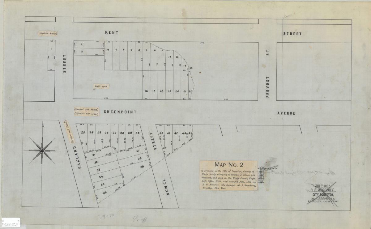
Map no. 2 of property in the city of Brooklyn, county of Kings, lately belonging to Samuel J. Tilden, now deceased, and filed in the Kings County Register’s Office, 1899, and surveyed July 1897: by B.R. Meserole, city surveyor
Map no. 2 of property in the city of Brooklyn, county of Kings, lately belonging to Samuel J. Tilden, now deceased, and filed in the Kings County Register’s Office, 1899, and surveyed July 1897: by B.R. Meserole, city surveyor
[1897]
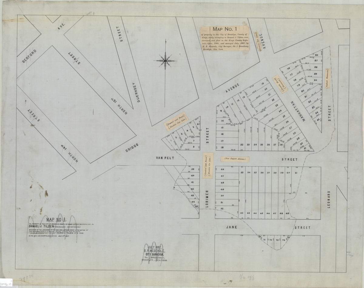
Map no. 1 of property in the city of Brooklyn, county of Kings, lately belonging to Samuel J. Tilden, now deceased, and filed in the Kings County Register’s Office, 1899, and surveyed July 1897: by B.R. Meserole, city surveyor
Map no. 1 of property in the city of Brooklyn, county of Kings, lately belonging to Samuel J. Tilden, now deceased, and filed in the Kings County Register’s Office, 1899, and surveyed July 1897: by B.R. Meserole, city surveyor
[1897]
Map no. 1 of property in the city of Brooklyn, county of Kings, lately belonging to Samuel J. Tilden, now deceased, and filed in the Kings County Register’s Office, 1899, and surveyed July 1897: by B.R. Meserole, city surveyor
Map no. 1 of property in the city of Brooklyn, county of Kings, lately belonging to Samuel J. Tilden, now deceased, and filed in the Kings County Register’s Office, 1899, and surveyed July 1897: by B.R. Meserole, city surveyor
July 1897
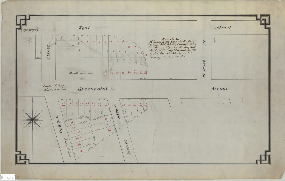
Map no. 2 of property in the city of Brooklyn, county of Kings, lately belonging to Samuel J. Tilden, now deceased, & filed in the Kings County Register’s Office, 1899, and surveyed July 1897: by B.R. Meserole, city surveyor
Map no. 2 of property in the city of Brooklyn, county of Kings, lately belonging to Samuel J. Tilden, now deceased, & filed in the Kings County Register’s Office, 1899, and surveyed July 1897: by B.R. Meserole, city surveyor
July 1897
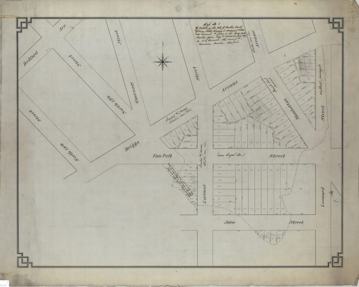
Map no. 3 of property in the city of Brooklyn, county of Kings, lately belonging to Samuel J. Tilden, now deceased, and filed in the Kings County Register’s Office, 1899, and surveyed July 1897: by B.R. Meserole, city surveyor
Map no. 3 of property in the city of Brooklyn, county of Kings, lately belonging to Samuel J. Tilden, now deceased, and filed in the Kings County Register’s Office, 1899, and surveyed July 1897: by B.R. Meserole, city surveyor
[1897]
Map of property belonging to William Wilkomn, situated in the borough of Brooklyn in the city of New York, Kings County, N.Y.: surveyed Dec. 1897: by Chas. S. Voorhies, civil engineer & city surveyor
Map of property belonging to William Wilkomn, situated in the borough of Brooklyn in the city of New York, Kings County, N.Y.: surveyed Dec. 1897: by Chas. S. Voorhies, civil engineer & city surveyor
December 1897
[Map of Ave. U between E. 4th St. and E. 5th St.]: surveyed … by Chas. S. Voorhies, civil eng. & city surveyor
[Map of Ave. U between E. 4th St. and E. 5th St.]: surveyed … by Chas. S. Voorhies, civil eng. & city surveyor
September 1898
[Map covering area east from Gravesend Bay to Harway Ave. at Bay 47th St.]: Chas S. Voorhis, city surveyor, Brooklyn, April 8, 1899
[Map covering area east from Gravesend Bay to Harway Ave. at Bay 47th St.]: Chas S. Voorhis, city surveyor, Brooklyn, April 8, 1899
1899
Previous
1
2
3
4
5
6
7