Center for Brooklyn History
Map Collections
Search
About
Othmer Library & Archives
Submit search query
Refine 416 records
Clear filters
2
Location
Albany County (N.Y.)
1
Astoria (New York, N.Y.)
4
Atlantic Basin (New York, N.Y.)
3
Babylon (N.Y. : Town)
2
Bath Beach (New York, N.Y.)
8
Bay Ridge (New York, N.Y.)
108
Bay Ridge Park (New York, N.Y.)
1
Bedford-Stuyvesant (New York, N.Y.)
67
Bellerose (New York, N.Y.)
1
Bensonhurst (New York, N.Y.)
17
Boerum Hill (New York, N.Y.)
6
Borough Park (New York, N.Y.)
23
Bridgehampton (N.Y.)
1
Brighton Beach (New York, N.Y.)
4
Brookhaven (N.Y. : Town)
3
Brookhaven (N.Y.)
2
Brooklyn (New York, N.Y.)
891
Brooklyn Heights (New York, N.Y.)
76
Brownsville (New York, N.Y.)
10
Bushwick (New York, N.Y.)
20
Canarsie (New York, N.Y.)
18
Carroll Gardens (New York, N.Y.)
21
Clinton County (N.Y.)
1
Clinton Hill (New York, N.Y.)
10
Cobble Hill (New York, N.Y.)
7
College Point (New York, N.Y.)
2
Coney Island (New York, N.Y.)
22
Constable (N.Y.)
1
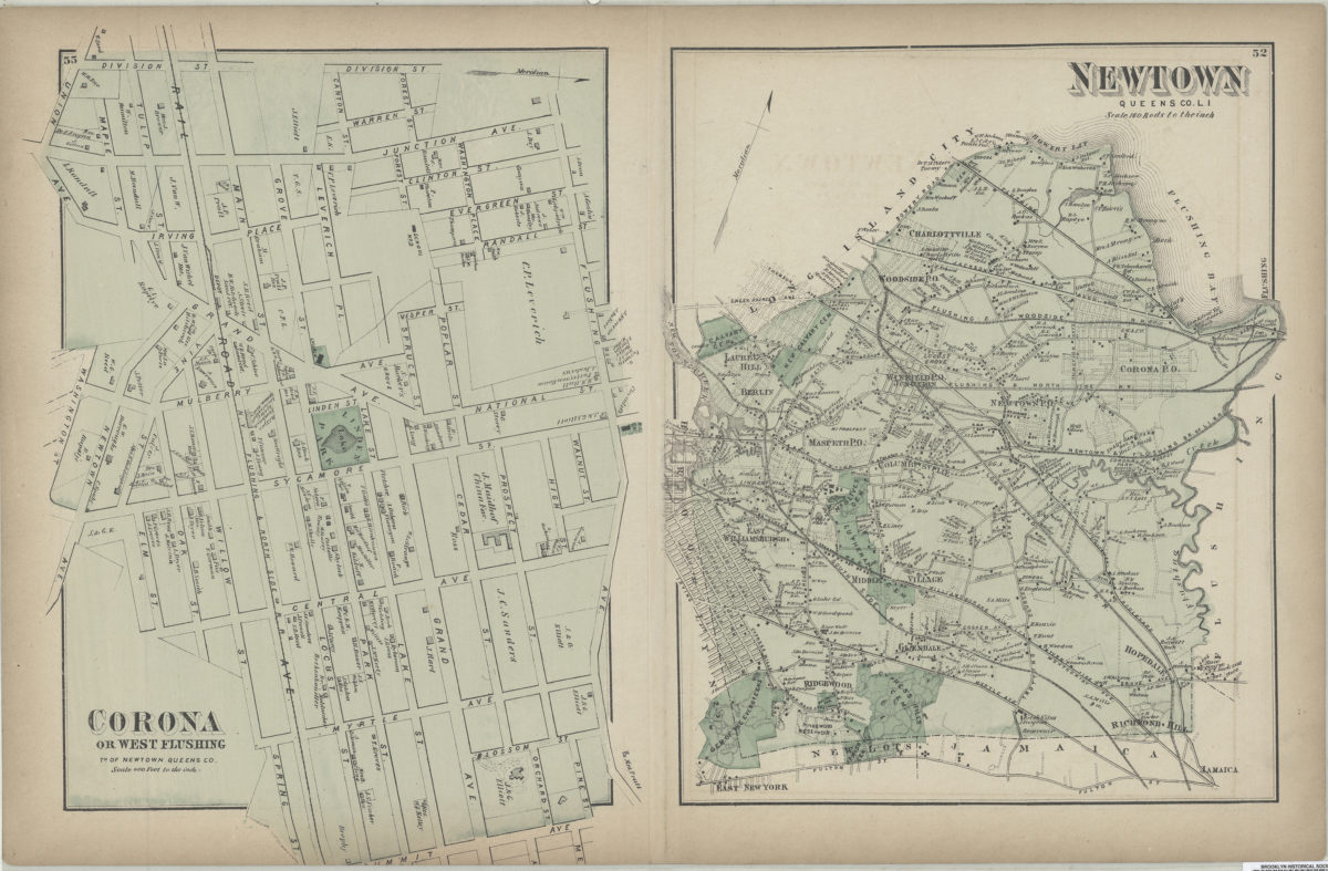
Corona (New York, N.Y.)
2
Cowenhoven Homestead (Brooklyn, New York, N.Y.)
1
Crown Heights (New York, N.Y.)
25
Cypress Hills (New York, N.Y.)
8
David Johnson Farm (New York, N.Y.)
1
Delaware River Valley (N.Y.-Del. and N.J.)
1
Denmark (N.Y.)
1
Dickinson (N.Y.)
2
Ditmas Park (New York, N.Y.)
1
Douglaston (New York, N.Y.)
1
Downtown Brooklyn (New York, N.Y.)
29
DUMBO Historic District (New York, N.Y.)
7
Dyker Heights (New York, N.Y.)
23
East Elmhurst (New York, N.Y.)
2
East Flatbush (New York, N.Y.)
23
East Harlem (New York, N.Y.)
1
East Midwood (New York, N.Y.)
1
East New York (New York, N.Y.)
16
East Patchogue (N.Y.)
1
Erasmus (New York, N.Y.)
1
Erie Basin (New York, N.Y.)
2
Far Rockaway (New York, N.Y.)
2
Farragut (New York, N.Y.)
1
Flatbush (New York, N.Y.)
35
Flatlands (New York, N.Y.)
19
Flushing (New York, N.Y.)
13
Fort Covington (N.Y.)
1
Fort Greene (New York, N.Y.)
22
Fort Hamilton (New York, N.Y.)
31
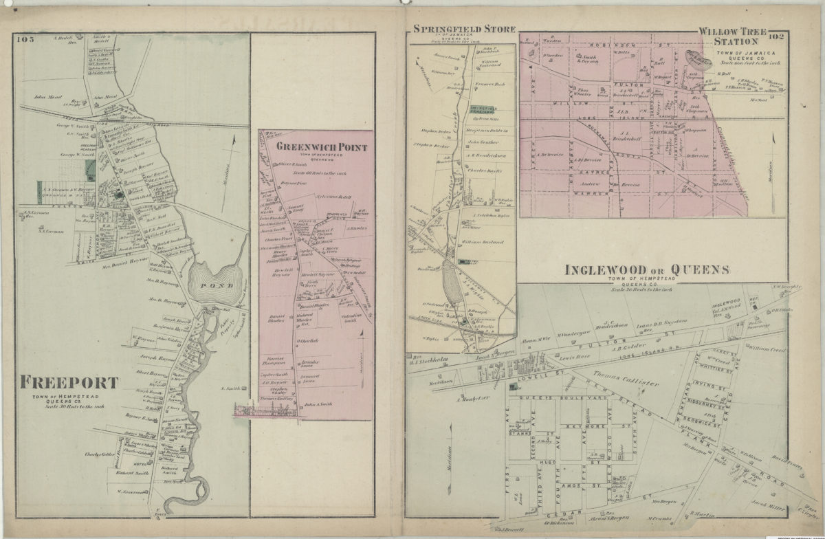
Freeport (N.Y.)
1
Fulton Ferry Historic District (New York, N.Y.)
5
Futurama (New York, N.Y.)
2
Glen Cove (N.Y.)
1
Gowanus (New York, N.Y.)
12
Gowanus Canal (New York, N.Y.)
5
Gravesend (New York, N.Y.)
25
Great Neck (N.Y.)
3
Green-Wood Cemetery (New York, N.Y.)
2
Greenboro (N.Y.)
1
Greenpoint (New York, N.Y.)
38
Greenport (N.Y.)
1
Harrisburgh (N.Y.)
1
Hempstead (N.Y.)
13
Hicksville (N.Y.)
1
Hinsdale (New York, N.Y.)
1
Hunters Point (New York, N.Y.)
2
Huntington (N.Y.)
7
Islip (N.Y.)
5
Jamaica (New York, N.Y.)
8
Kensington (New York, N.Y.)
11
Kings County (New York, N.Y.)
8
Lewis County (N.Y.)
2
Long Island (N.Y.)
197
Long Island City (New York, N.Y.)
8
Manhattan (New York, N.Y.)
120
Marine Park (New York, N.Y.)
5
Martinsburg (N.Y.)
1
Marway Farm (New York, N.Y.)
1
Maspeth (New York, N.Y.)
2
Mattituck (N.Y.)
1
Midwood (New York, N.Y.)
9
Miller Place (N.Y.)
1
Mohawk River Valley (N.Y.)
3
Montauk (N.Y.)
4
Nassau County (N.Y.)
24
New Lots (New York, N.Y.)
1
New Utrecht (New York, N.Y.)
9
New York (N.Y.)
164
New York (State)
95
New York Metropolitan Area
40
Newtown (Queens County, N.Y.)
4
North Hempstead (N.Y. : Town)
4
Northport Bay (N.Y. : Bay)
1
Nottingham (New York, N.Y.)
2
Noyack (N.Y.)
1
Old Bethpage (N.Y.)
1
Oneida County (N.Y.)
2
Orwell (N.Y.)
2
Osceola (N.Y.)
2
Oswego County (N.Y.)
4
Oyster Bay (N.Y.)
9
Park Slope (New York, N.Y.)
16
Parkville (New York, N.Y.)
2
Patchogue (N.Y.)
2
Pearsalls (N.Y.)
1
Pierrepont (N.Y.)
1
Pierrepont Homestead (New York, N.Y.)
6
Port Jefferson (N.Y.)
1
Prospect Heights (New York, N.Y.)
16
Prospect Lefferts Gardens (Brooklyn, New York, N.Y.)
16
Prospect Park (New York, N.Y.)
25
Prospect Park South (New York, N.Y.)
8
Queens (New York, N.Y.)
83
Quiogue (N.Y.)
1
Ravenswood (New York, N.Y.)
4
Red Hook (New York, N.Y.)
19
Rensselaer County (N.Y.)
2
Richmond Hill (New York, N.Y.)
2
Riverhead (N.Y.)
3
Rockaway Beach (New York, N.Y.)
1
Rockville Centre (N.Y.)
2
Rodman (N.Y.)
1
Roslyn (N.Y.)
3
Roslyn Harbor (N.Y.)
1
Rye (N.Y.)
1
Sag Harbor (N.Y.)
2
Sayville (N.Y.)
1
Schoharie County (N.Y.)
1
Schoharie Creek Valley (N.Y.)
1
Sea Gate (New York, N.Y.)
7
Sheepshead Bay (New York, N.Y.)
13
Shelter Island (N.Y.)
2
Smithtown (N.Y. : Town)
4
South Greenfield (New York, N.Y.)
1
Southampton (N.Y.)
5
Southold (N.Y.)
4
Stony Brook (N.Y.)
1
Sunnyside (New York, N.Y.)
1
Sunset Park (New York, N.Y.)
53
Susquehanna River Valley
1
Van Pelt Manor House (Brooklyn, New York, N.Y.)
1
Vinegar Hill Historic District (New York, N.Y.)
4
Wallabout Bay (New York, N.Y.)
6
Weeksville (New York, N.Y.)
7
West Turin (N.Y.)
1
Westhampton Beach (N.Y.)
1
Westville (Franklin County, N.Y.)
1
Whitestone (New York, N.Y.)
3
Williamsburg (New York, N.Y.)
36
Windsor Terrace (New York, N.Y.)
10
Woodhaven (New York, N.Y.)
1
Woodside (New York, N.Y.)
3
Yaphank (N.Y.)
1
Show 141 more
Subject
Aqueducts
3
Bays
5
Buildings
12
Canals
15
Central business districts
10
Decedents' estates
1
docks
2
Farms
2
ferries
32
Fills (Earthwork)
4
Grading (Earthwork)
1
Land grants
12
Land tenure
1
Landforms
15
Landowners
434
Parks
35
Piers
25
Plank roads
1
Ponds
6
Prisons
1
Railroads
72
Railroads, Elevated
24
Real property
619
Riparian rights
13
Rivers
16
Roads
117
Salt marshes
2
Sewerage
7
Streets
46
Submerged lands
17
Tide-waters
2
Waterfronts
5
Watersheds
5
Waterways
2
Show 14 more
Date
19th Century
945
20th Century
469
or enter range:
from
to
Genres
Bathymetric maps
94
Cadastral maps
597
Early maps
35
Historical maps
53
Manuscript maps
365
Map
191
Pictorial maps
38
Public utility maps
15
Thematic maps
60
Topographic maps
70
Transportation maps
120
Zoning maps
55
Sort by:
Date (earliest)
Date (most recent)
Ravenswood, part of Long Island City
Ravenswood, part of Long Island City
[1873]
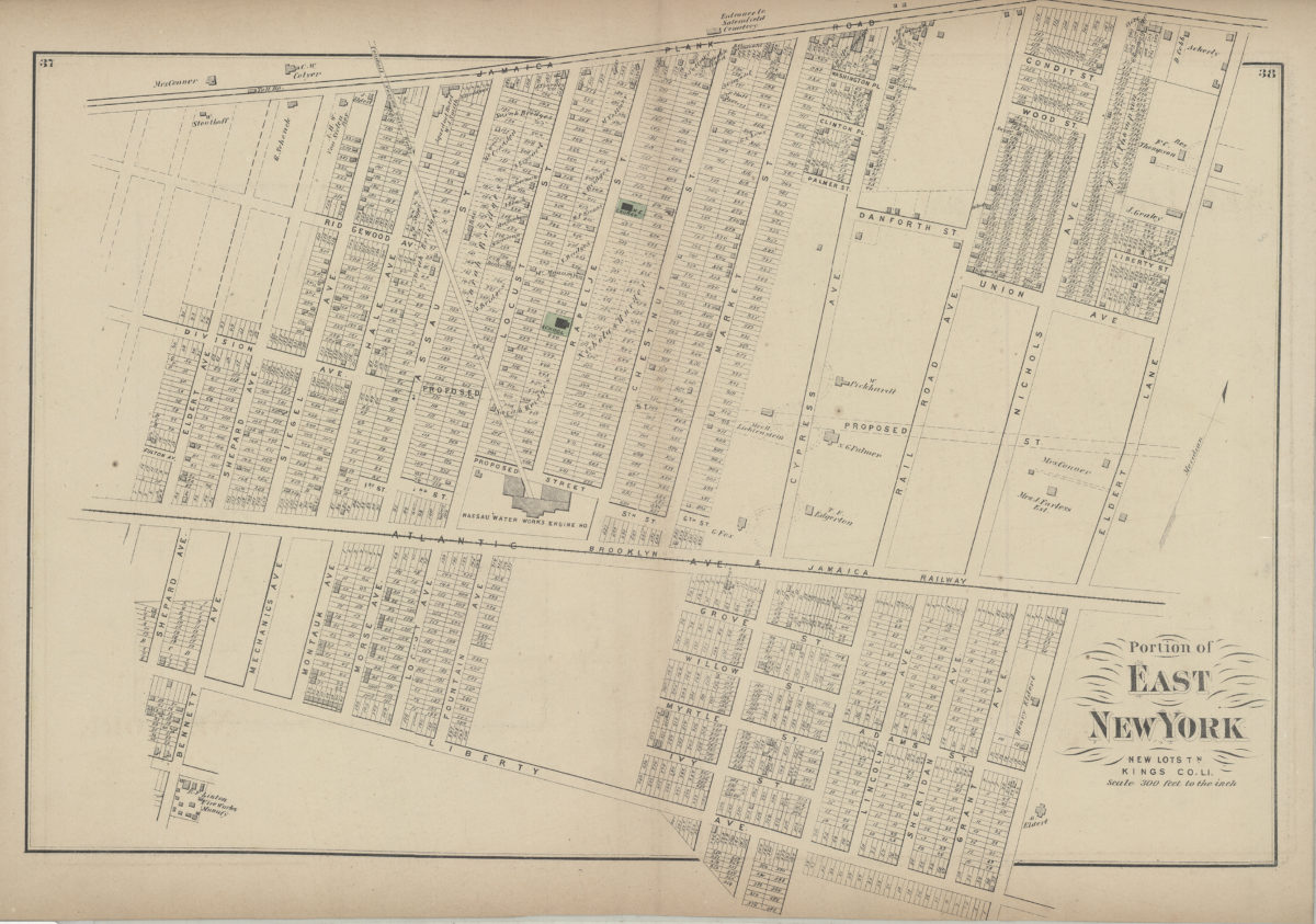
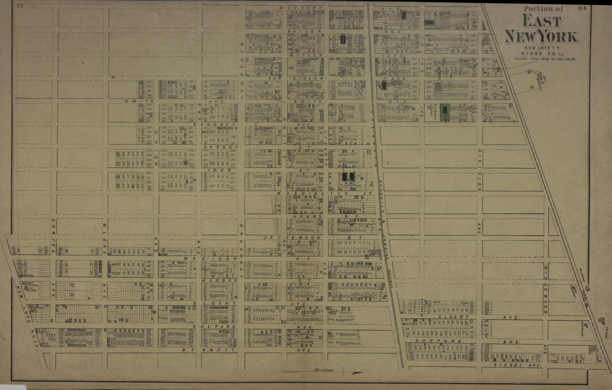
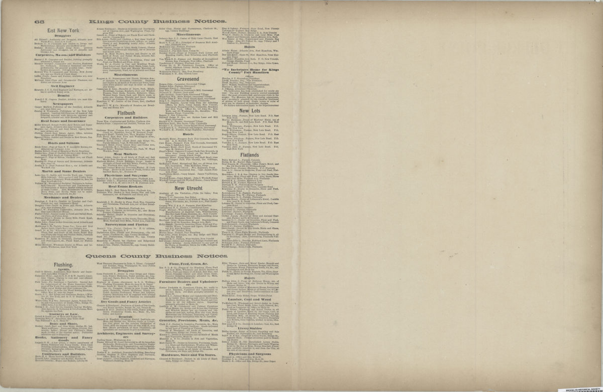
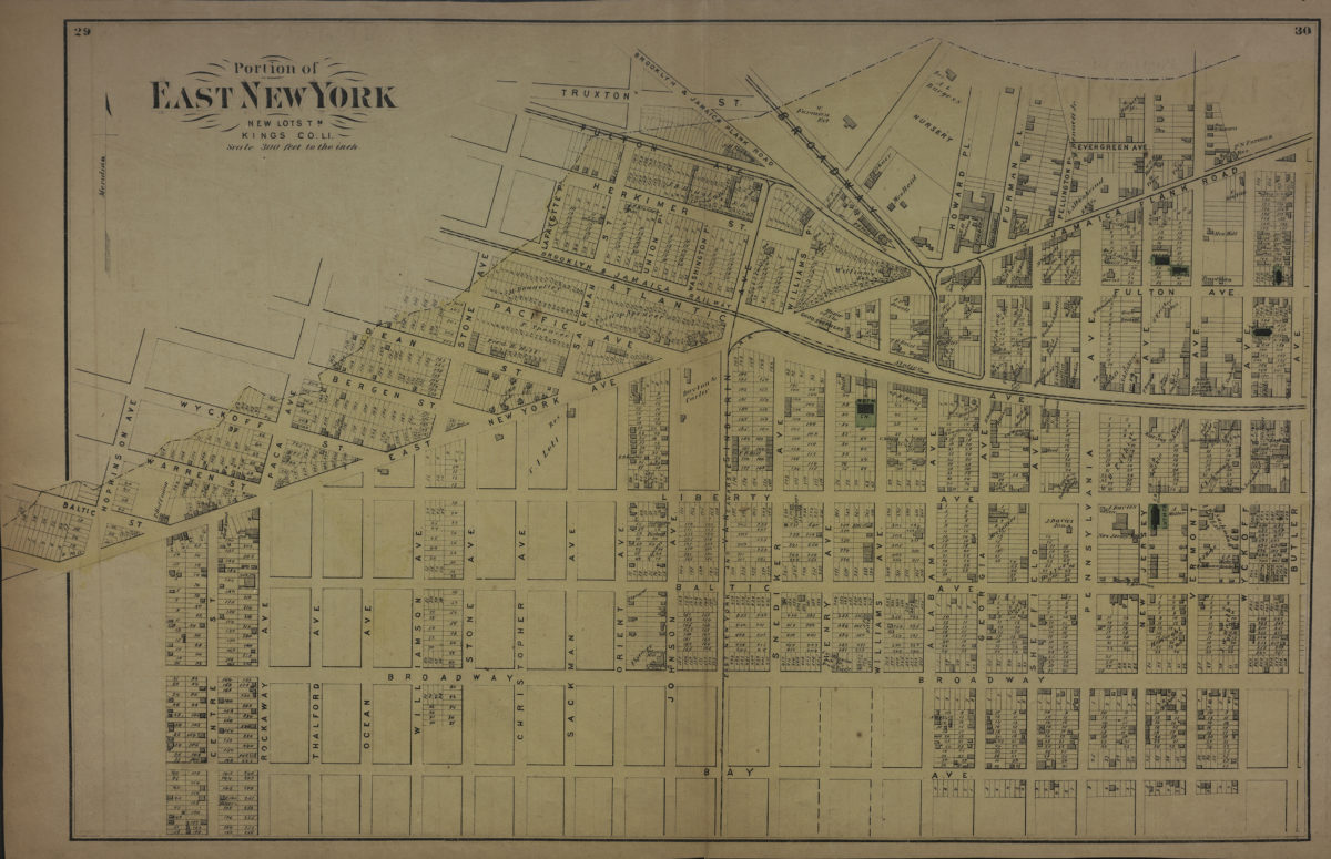
Portion of East New York, New Lots Tn., Kings Co., L.I.
Portion of East New York, New Lots Tn., Kings Co., L.I.
[1873]
Portion of East New York, New Lots Tn., Kings Co., L.I.
Portion of East New York, New Lots Tn., Kings Co., L.I.
[1873]
Woodhaven, town of Jamaica, Queens Co
Woodhaven, town of Jamaica, Queens Co
[1873]
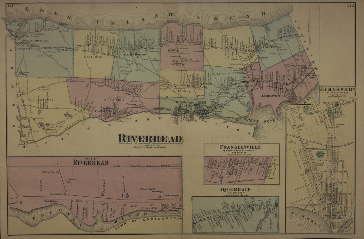
Riverhead, Suffolk Co
Riverhead, Suffolk Co
[1873]
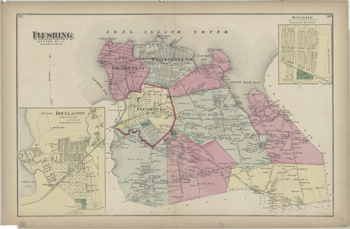
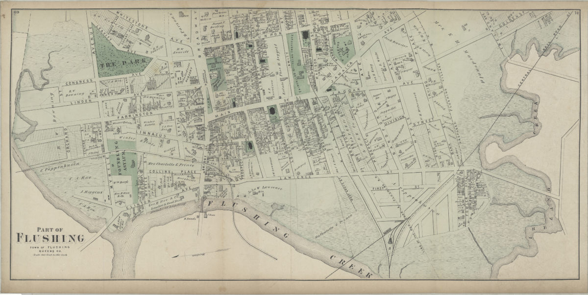
Flushing, Queens Co., L.I.
Flushing, Queens Co., L.I.
[1873]
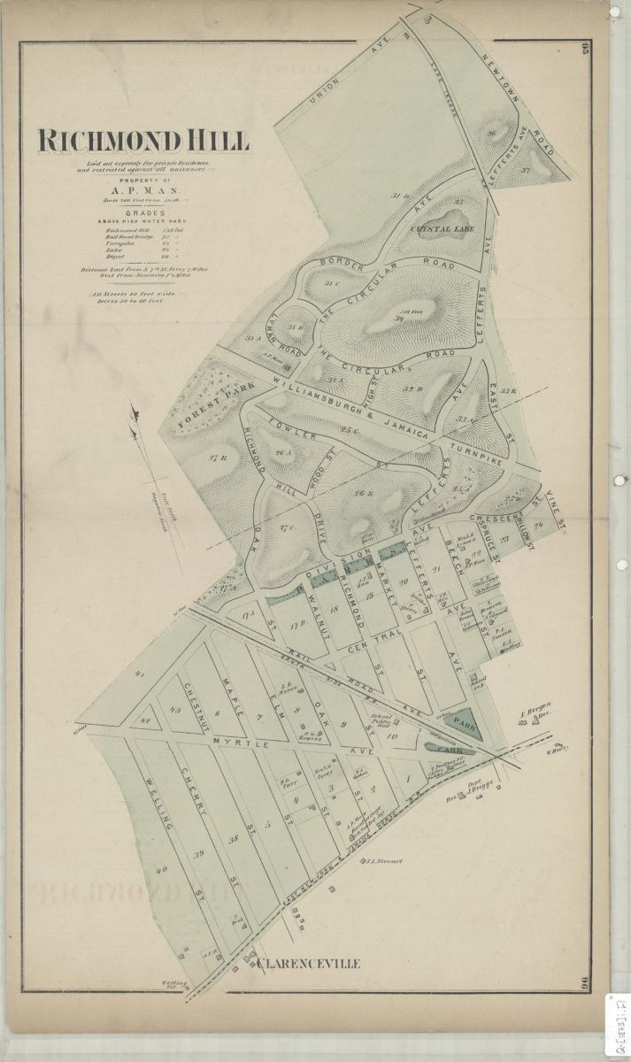
Richmond Hill: laid out expressly for private residences and against all nuisances : property of A.P. Man
Richmond Hill: laid out expressly for private residences and against all nuisances : property of A.P. Man
[1873]
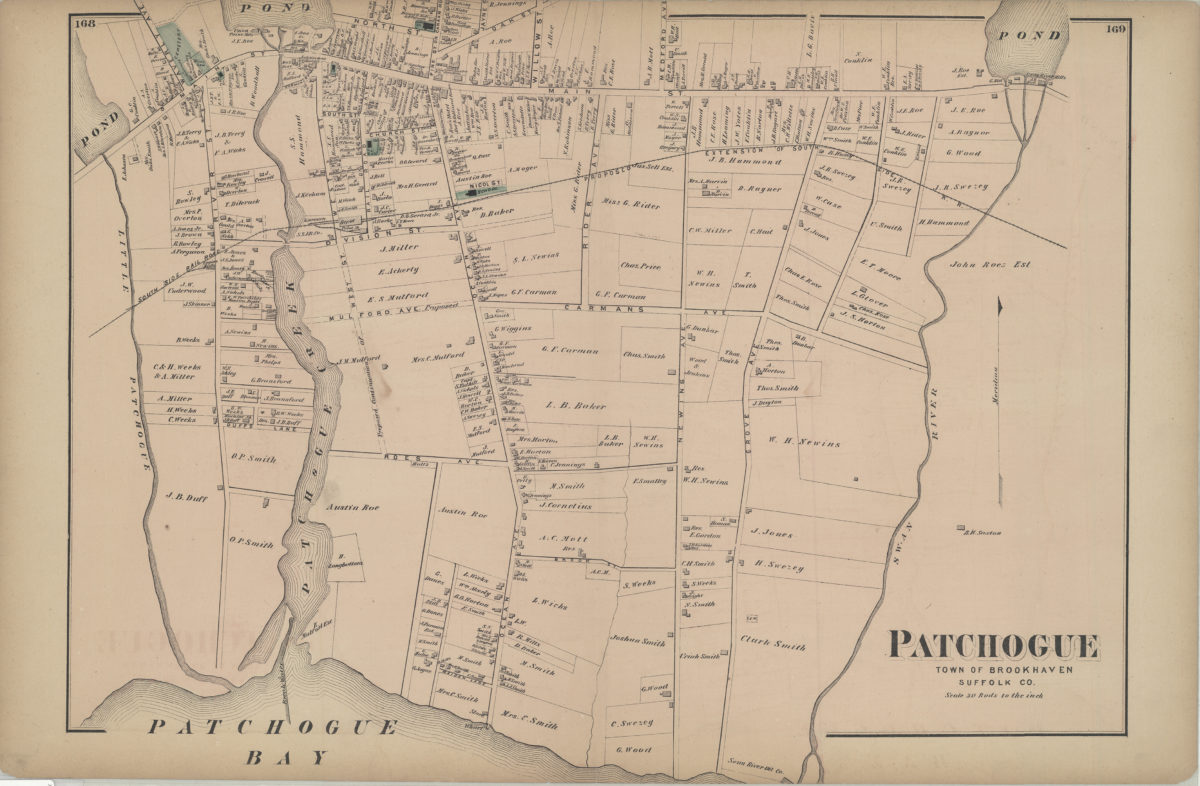
Patchogue, town of Brookhaven, Suffolk Co
Patchogue, town of Brookhaven, Suffolk Co
[1873]
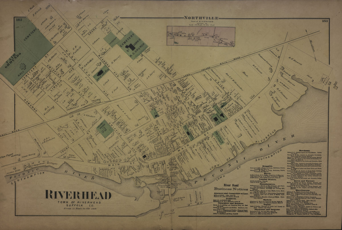
Riverhead, town of Riverhead, Suffolk Co
Riverhead, town of Riverhead, Suffolk Co
[1873]
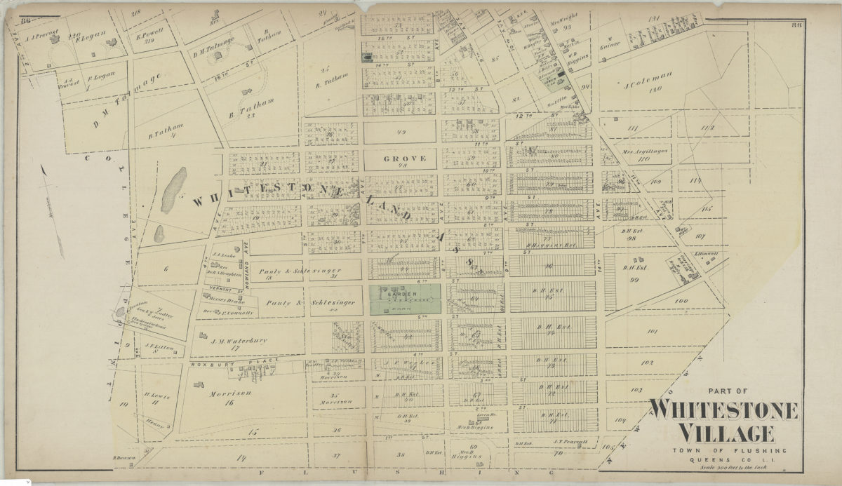
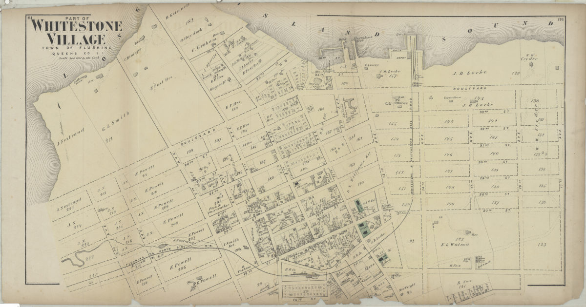
Part of Whitestone Village, town of Flushing, Queens Co., L.I.
Part of Whitestone Village, town of Flushing, Queens Co., L.I.
[1873]
Part of Whitestone Village, town of Flushing, Queens Co., L.I.
Part of Whitestone Village, town of Flushing, Queens Co., L.I.
[1873]
Part of College Point, town of Flushing, Queens Co
Part of College Point, town of Flushing, Queens Co
[1873]
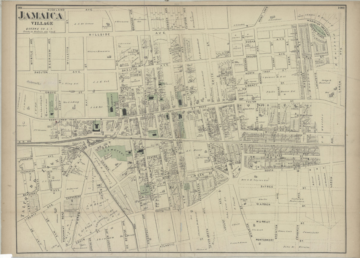
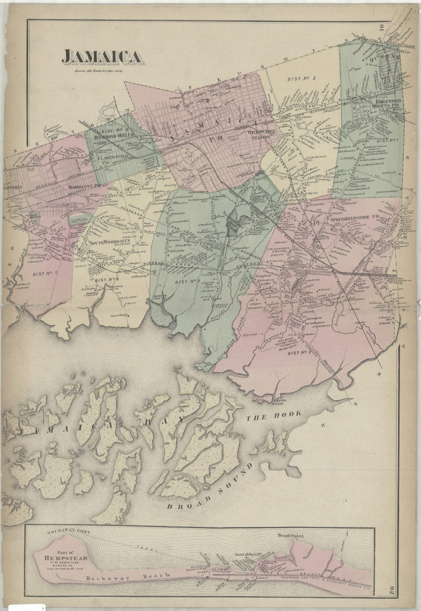
Jamaica Village, Queens Co., L.I.
Jamaica Village, Queens Co., L.I.
[1873]
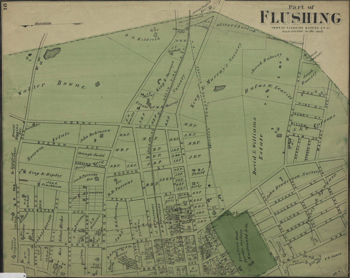
Part of Flushing, town of Flushing, Queens Co., L.I.
Part of Flushing, town of Flushing, Queens Co., L.I.
[1873]
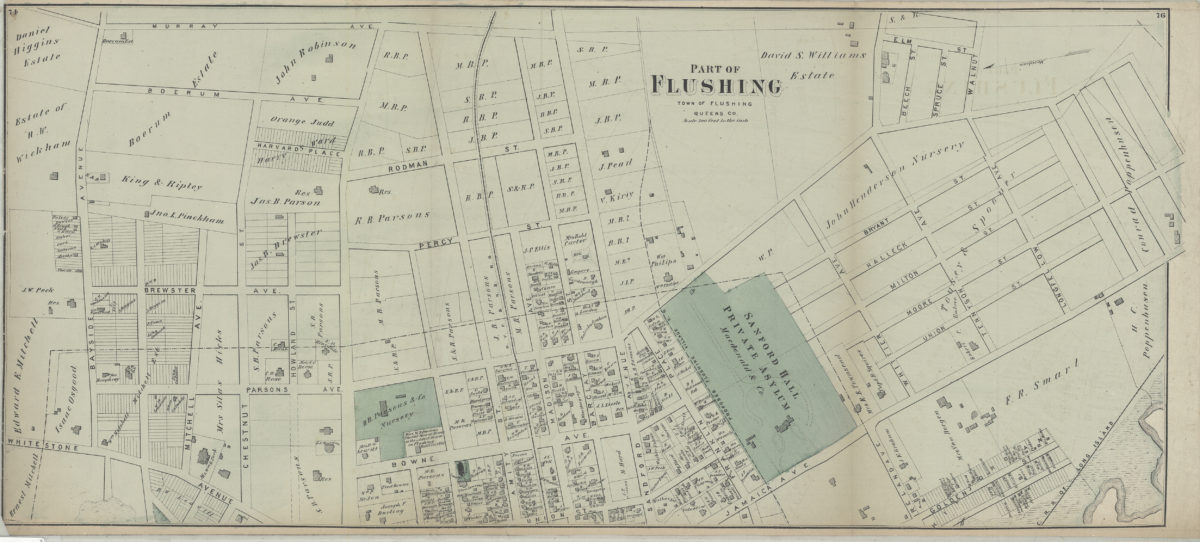
Part of Flushing, town of Flushing, Queens Co
Part of Flushing, town of Flushing, Queens Co
[1873]
Part of Flushing, town of Flushing, Queens Co
Part of Flushing, town of Flushing, Queens Co
[1873]
Portion of East New York, New Lots Tn., Kings Co., L.I.
Portion of East New York, New Lots Tn., Kings Co., L.I.
[1873]
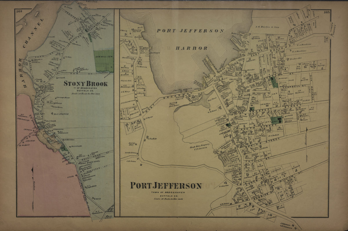
Port Jefferson, town of Brookhaven, Suffolk Co. ; Stony Brook, tn. of Brookhaven, Suffolk Co
Port Jefferson, town of Brookhaven, Suffolk Co. ; Stony Brook, tn. of Brookhaven, Suffolk Co
[1873]
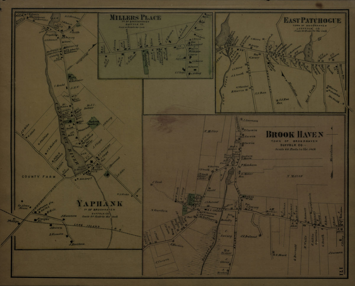
Brookhaven, town of Brookhaven, Suffolk Co. ; Yaphank, tn. of Brookhaven, Suffolk Co. ; Millers [i.e. Miller] Place, tn. of Brookhaven, Suffolk Co. ; East Patchogue, town of Brookhaven, Suffolk Co
Brookhaven, town of Brookhaven, Suffolk Co. ; Yaphank, tn. of Brookhaven, Suffolk Co. ; Millers [i.e. Miller] Place, tn. of Brookhaven, Suffolk Co. ; East Patchogue, town of Brookhaven, Suffolk Co
[1873]
Jamaica
Jamaica
[1873]
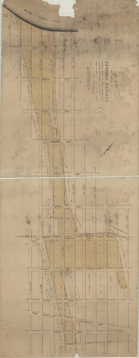
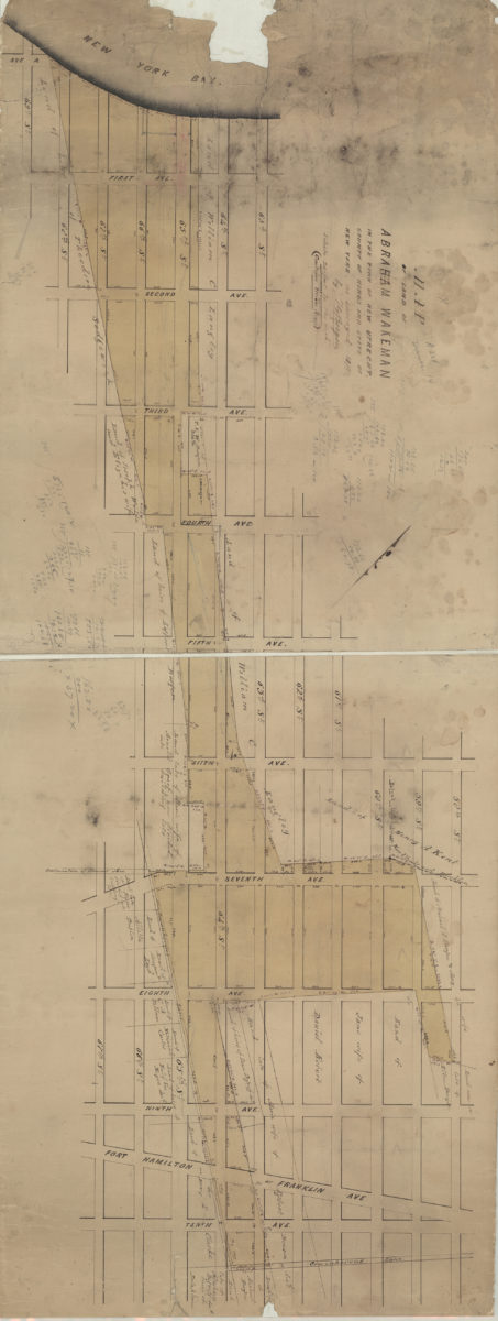
Map of land of Abraham Wakeman, in the town of New Utrecht, county of Kings, and state of New York: as surveyed by T.G. Bergen
Map of land of Abraham Wakeman, in the town of New Utrecht, county of Kings, and state of New York: as surveyed by T.G. Bergen
1873
[Maps of land of Inebriates Home near Fort Hamilton in the county of Kings, and the state of New York]
[Maps of land of Inebriates Home near Fort Hamilton in the county of Kings, and the state of New York]
1873
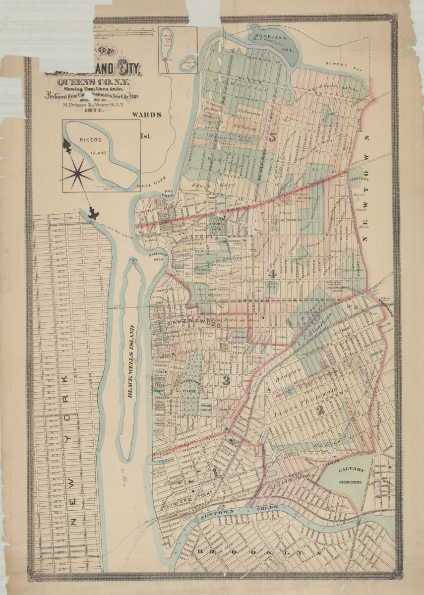
Map of Long Island City, Queens Co. N.Y.: showing farm lines &c. &c.: reduced from Commissioners new city map
Map of Long Island City, Queens Co. N.Y.: showing farm lines &c. &c.: reduced from Commissioners new city map
1874
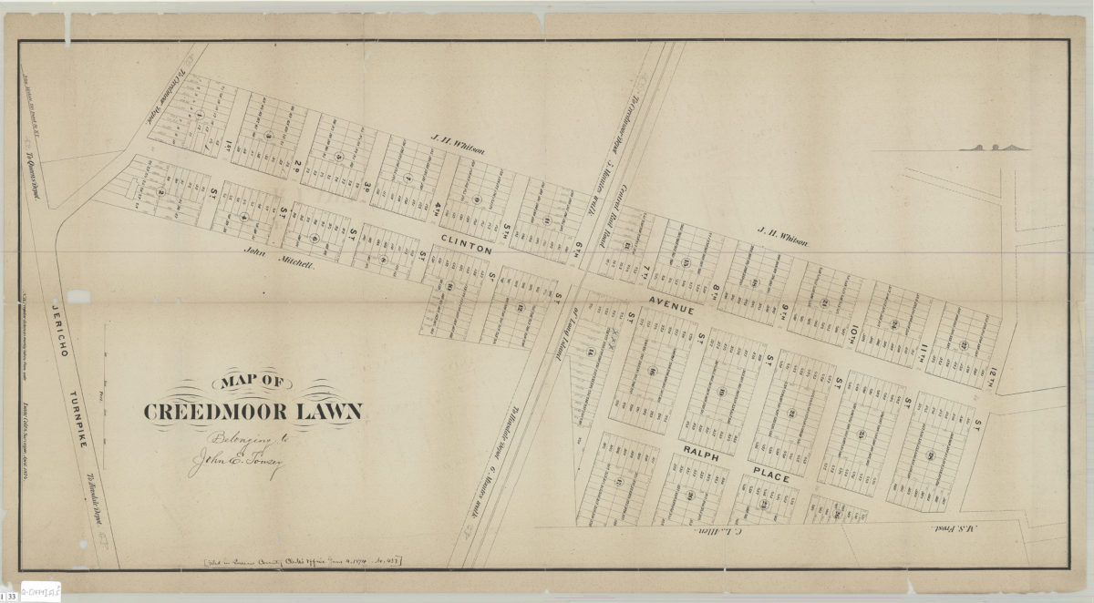
Map of Creedmoor Lawn: Isaac Coles, surveyor, April 1874
Map of Creedmoor Lawn: Isaac Coles, surveyor, April 1874
[1874]
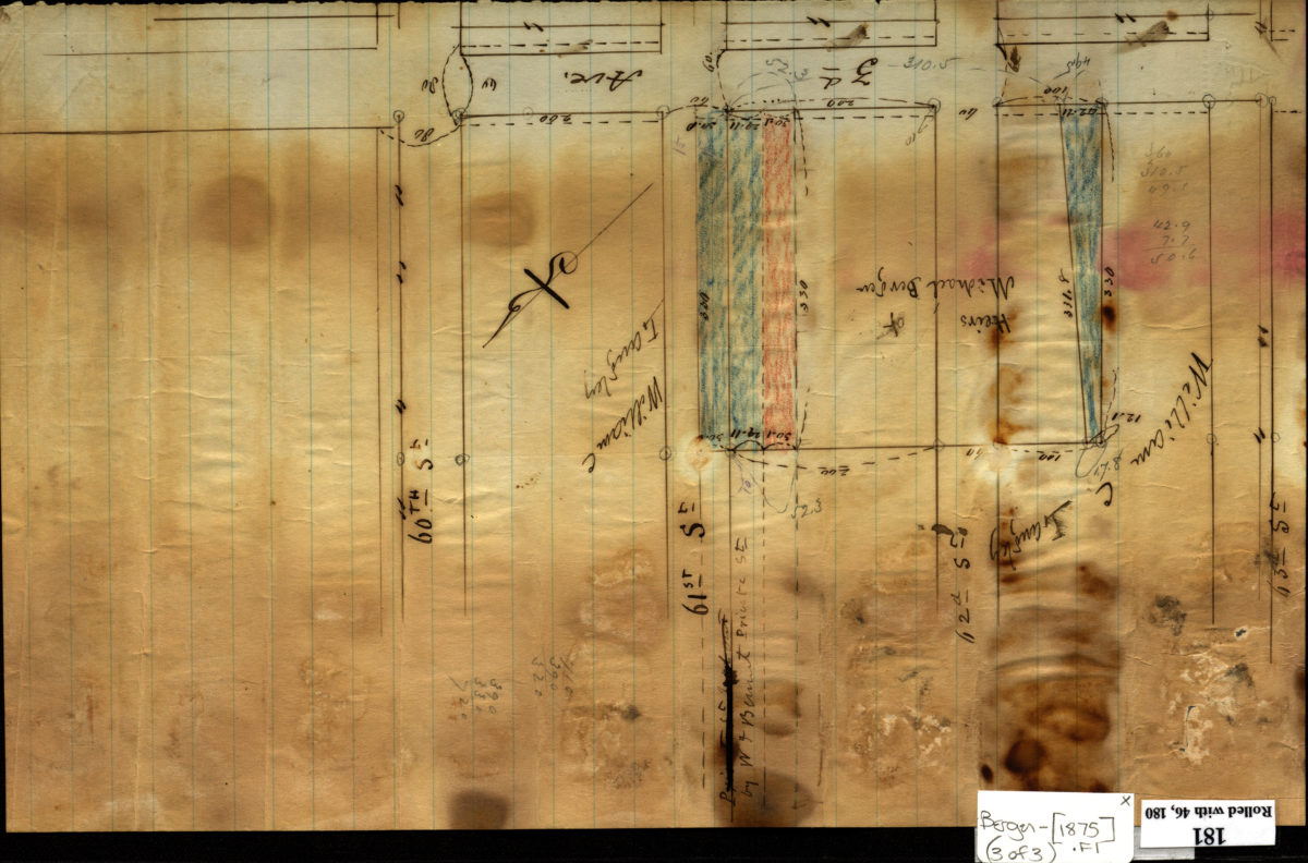
[Maps documenting reciprocal land sale of property along 3rd Avenue between heirs of Michael Bergen and William C. Langley]
[Maps documenting reciprocal land sale of property along 3rd Avenue between heirs of Michael Bergen and William C. Langley]
[ca. 1875]
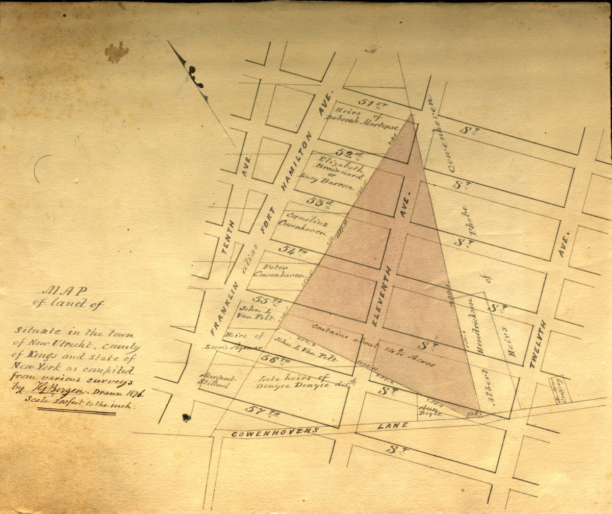
Map of land of … situate[d] in the town of New Utrecht, county of Kings, and state of New York, as compiled from various surveys: by T.G. Bergen
Map of land of … situate[d] in the town of New Utrecht, county of Kings, and state of New York, as compiled from various surveys: by T.G. Bergen
1876
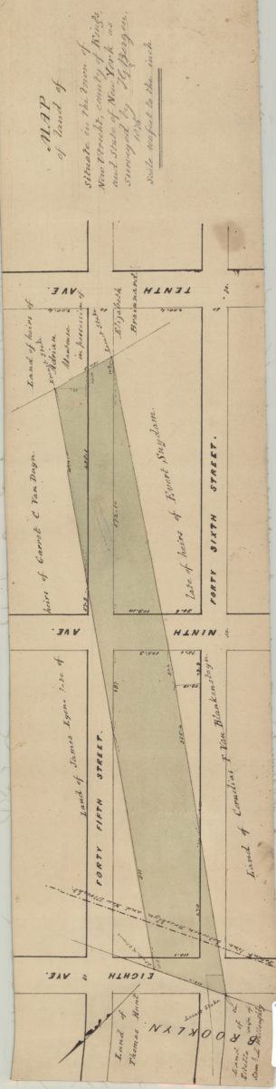
Map of land of … situate[d] in the town of New Utrecht, county of Kings, and state of New York, as surveyed: by T.G. Bergen
Map of land of … situate[d] in the town of New Utrecht, county of Kings, and state of New York, as surveyed: by T.G. Bergen
1876
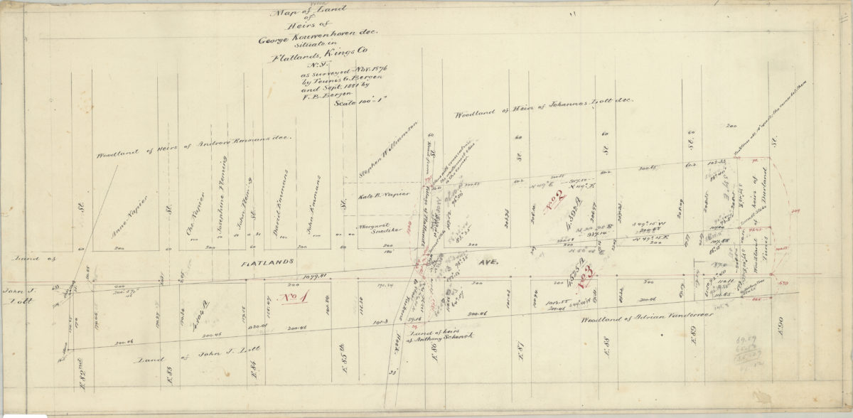
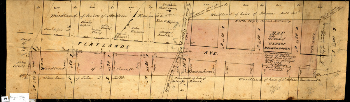
Map of woodland of heirs of George Kouwenhoven, dec., situate[d] in Flatlands, Kings Co., N.Y., as surveyed Nov. 1876: by Teunis G. Bergen, and Sept. 1881 by V.B. Bergen
Map of woodland of heirs of George Kouwenhoven, dec., situate[d] in Flatlands, Kings Co., N.Y., as surveyed Nov. 1876: by Teunis G. Bergen, and Sept. 1881 by V.B. Bergen
1876-1881
Map of woodland of George Kouwenhoven situated in the Town of Flatlands, and County of Kings: as surveyed Nov. 1876 by T.G. Bergen
Map of woodland of George Kouwenhoven situated in the Town of Flatlands, and County of Kings: as surveyed Nov. 1876 by T.G. Bergen
November 1876
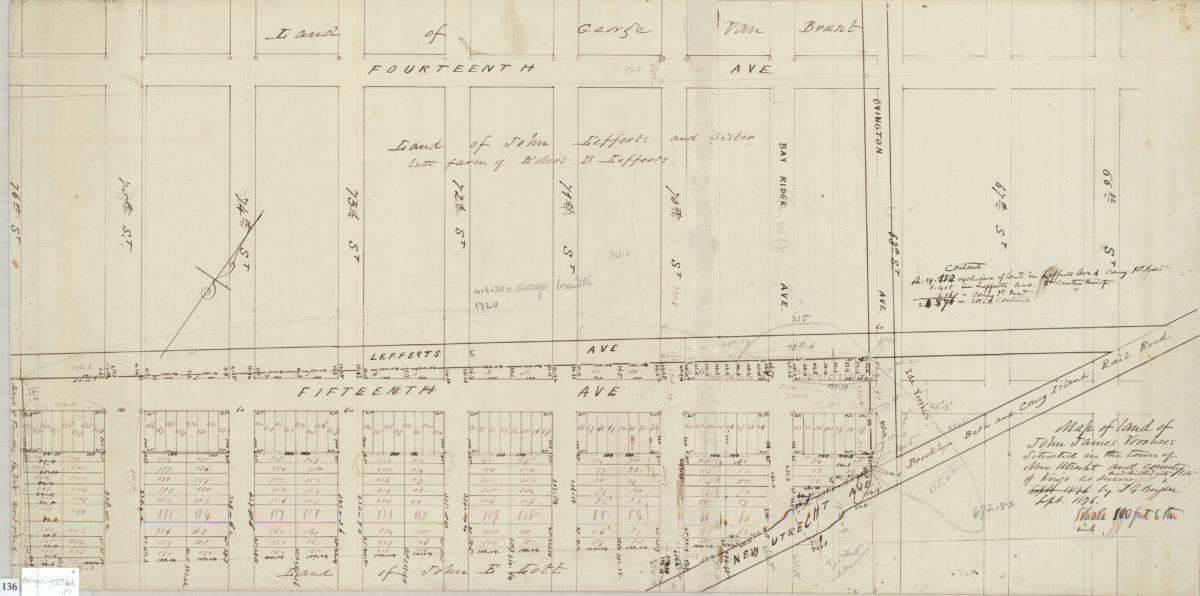
Map of land of John James Voorhees situated in the town of New Utrecht and County of Kings: as surveyed and divided into lots by T.G. Bergen
Map of land of John James Voorhees situated in the town of New Utrecht and County of Kings: as surveyed and divided into lots by T.G. Bergen
Sept 1876
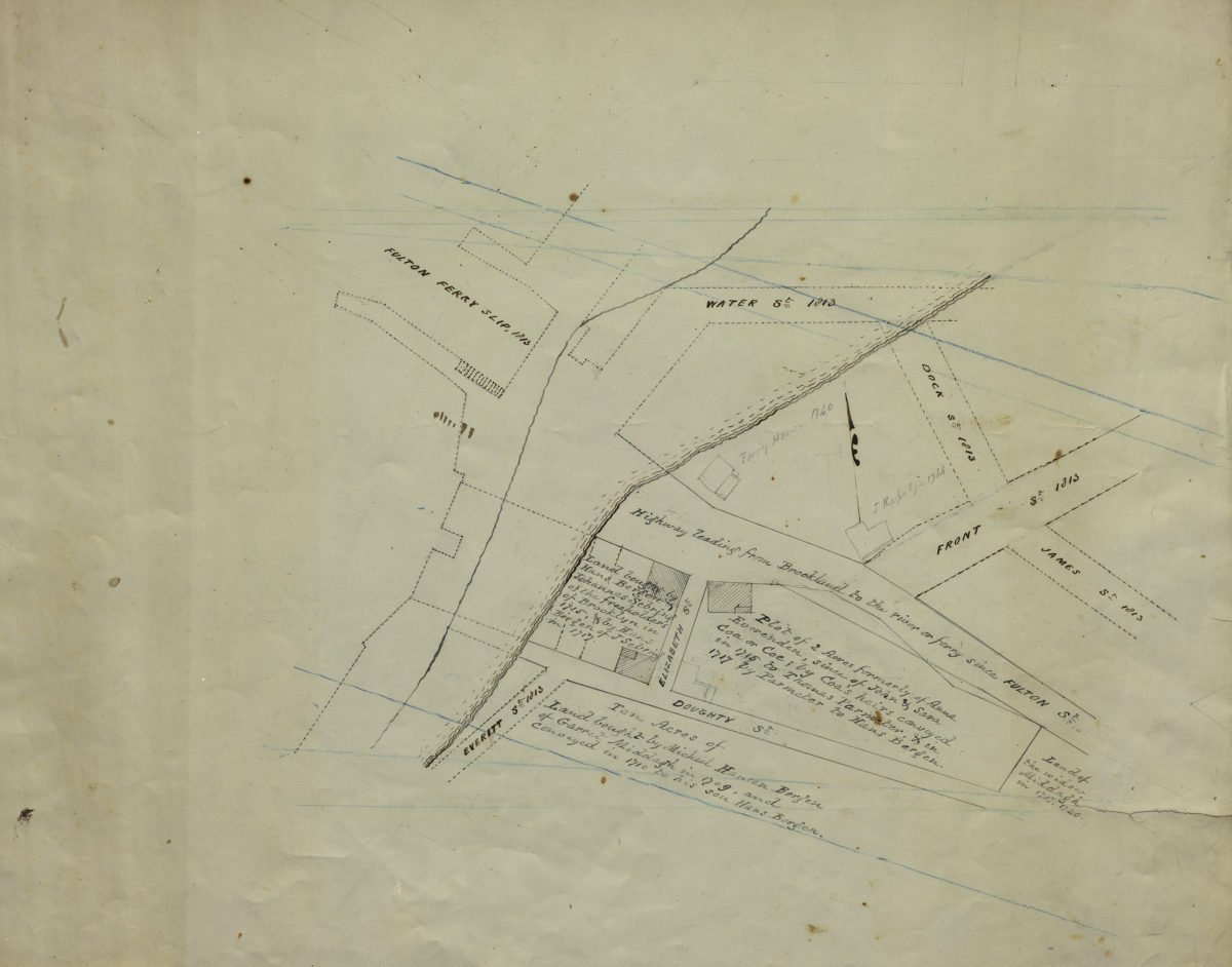
[Map of Hans Bergen’s land at Brooklyn Ferry]
[Map of Hans Bergen’s land at Brooklyn Ferry]
[ca. 1876]
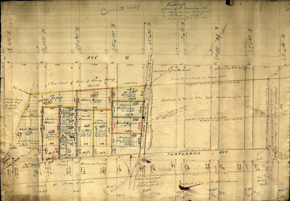
Woodland of heirs of A. Emmaus … [text illegible] in Canarsie as surveyed: by T.G. Bergen
Woodland of heirs of A. Emmaus … [text illegible] in Canarsie as surveyed: by T.G. Bergen
1876
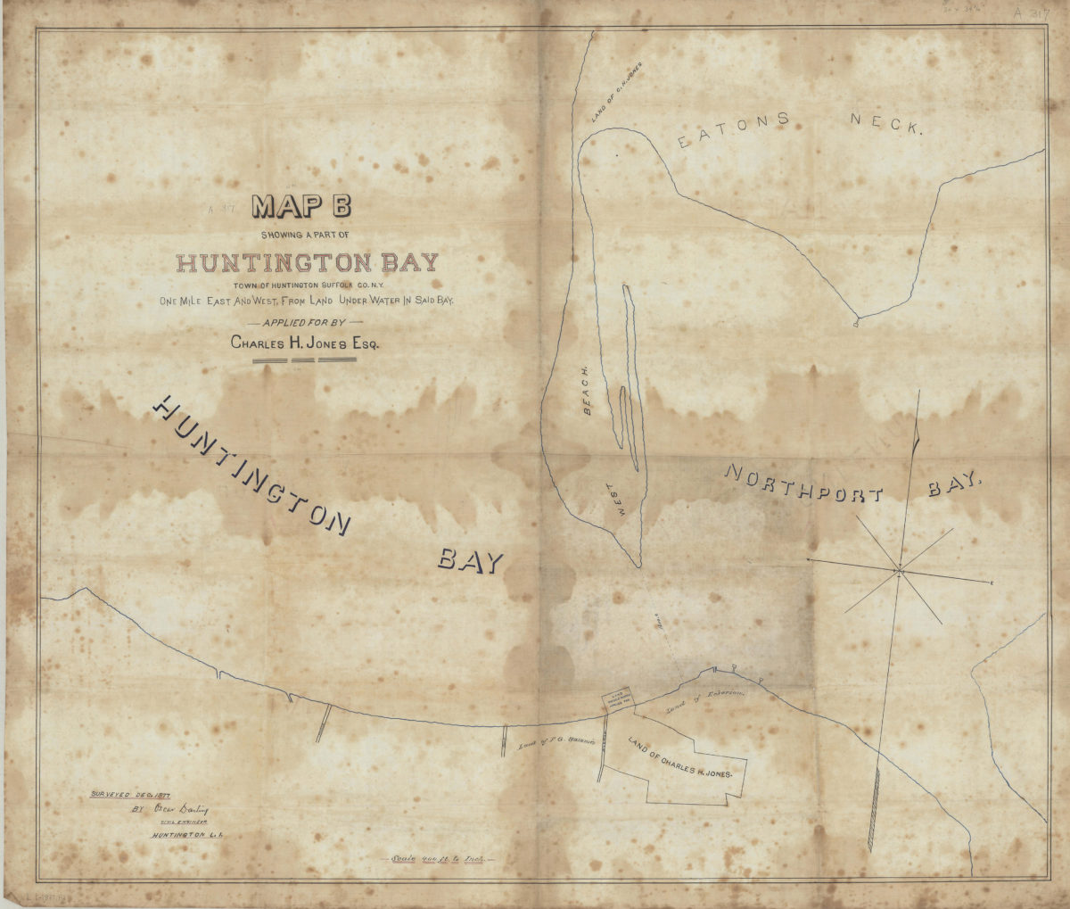
Map B showing a part of Huntington Bay: town of Huntington, Suffolk Co., N.Y., one mile east and west from land under water in said bay, applied for by Charles H. Jones, Esq.: surveyed Dec. 1877 by Oscar Darling, civil engineer, Huntington L.I.
Map B showing a part of Huntington Bay: town of Huntington, Suffolk Co., N.Y., one mile east and west from land under water in said bay, applied for by Charles H. Jones, Esq.: surveyed Dec. 1877 by Oscar Darling, civil engineer, Huntington L.I.
December 1877
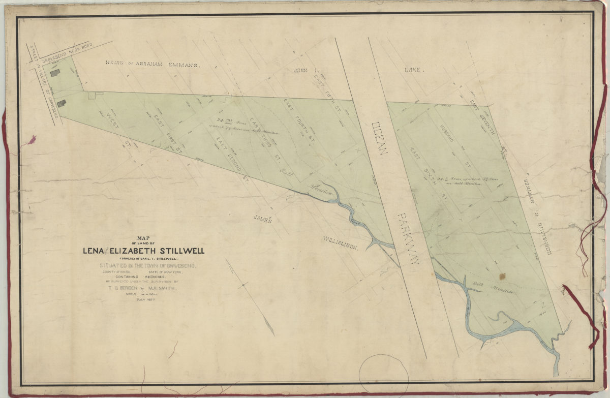
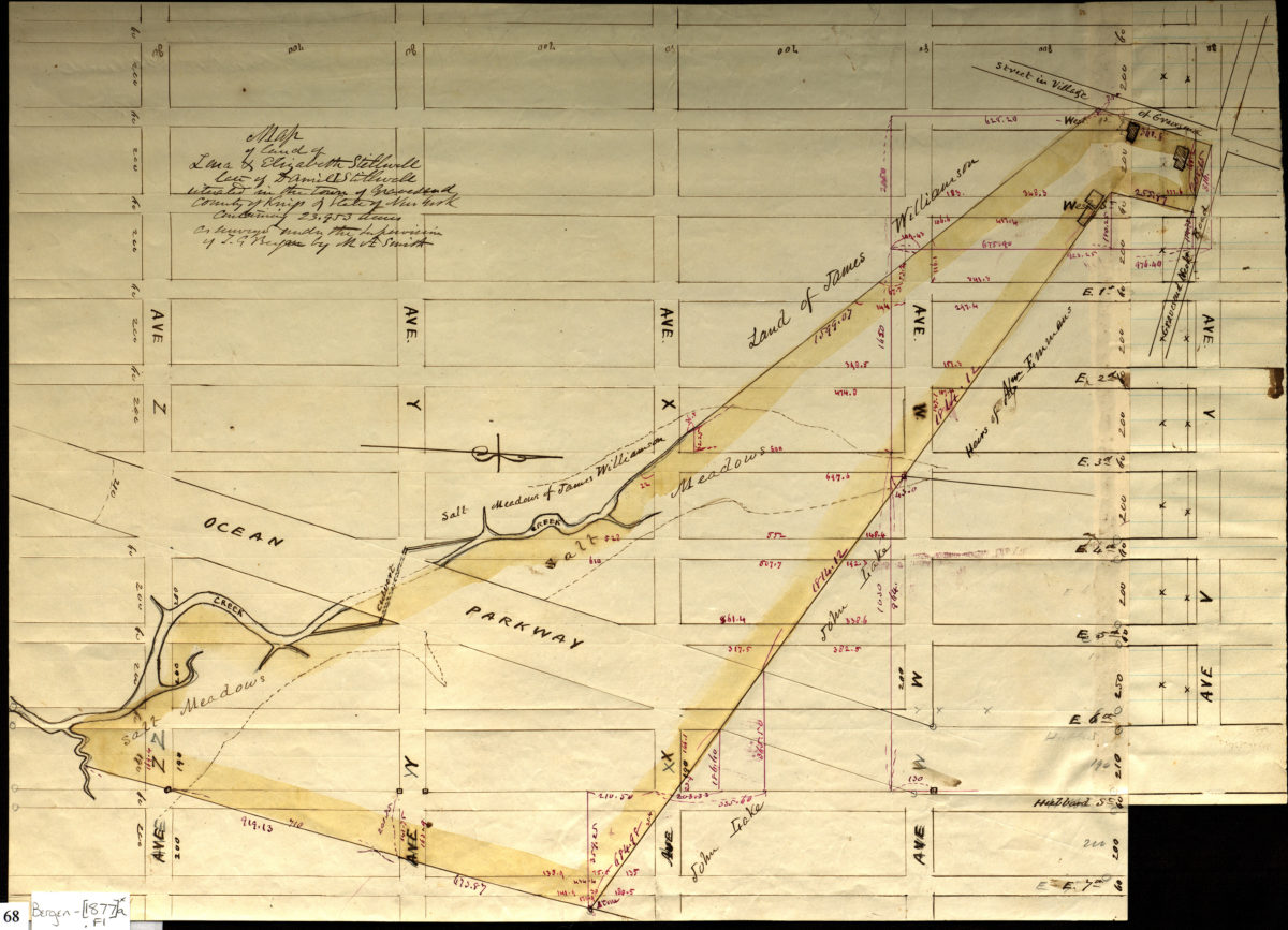
Map of land of Lena [and] Elizabeth Stillwell, formerly of Daniel I. Stillwell, situated in the town of Gravesend, county of Kings, state of New York, containing 48 693/1000 acres: as surveyed under the supervision of T.G Bergen: by M.A. Smith
Map of land of Lena [and] Elizabeth Stillwell, formerly of Daniel I. Stillwell, situated in the town of Gravesend, county of Kings, state of New York, containing 48 693/1000 acres: as surveyed under the supervision of T.G Bergen: by M.A. Smith
July 1877
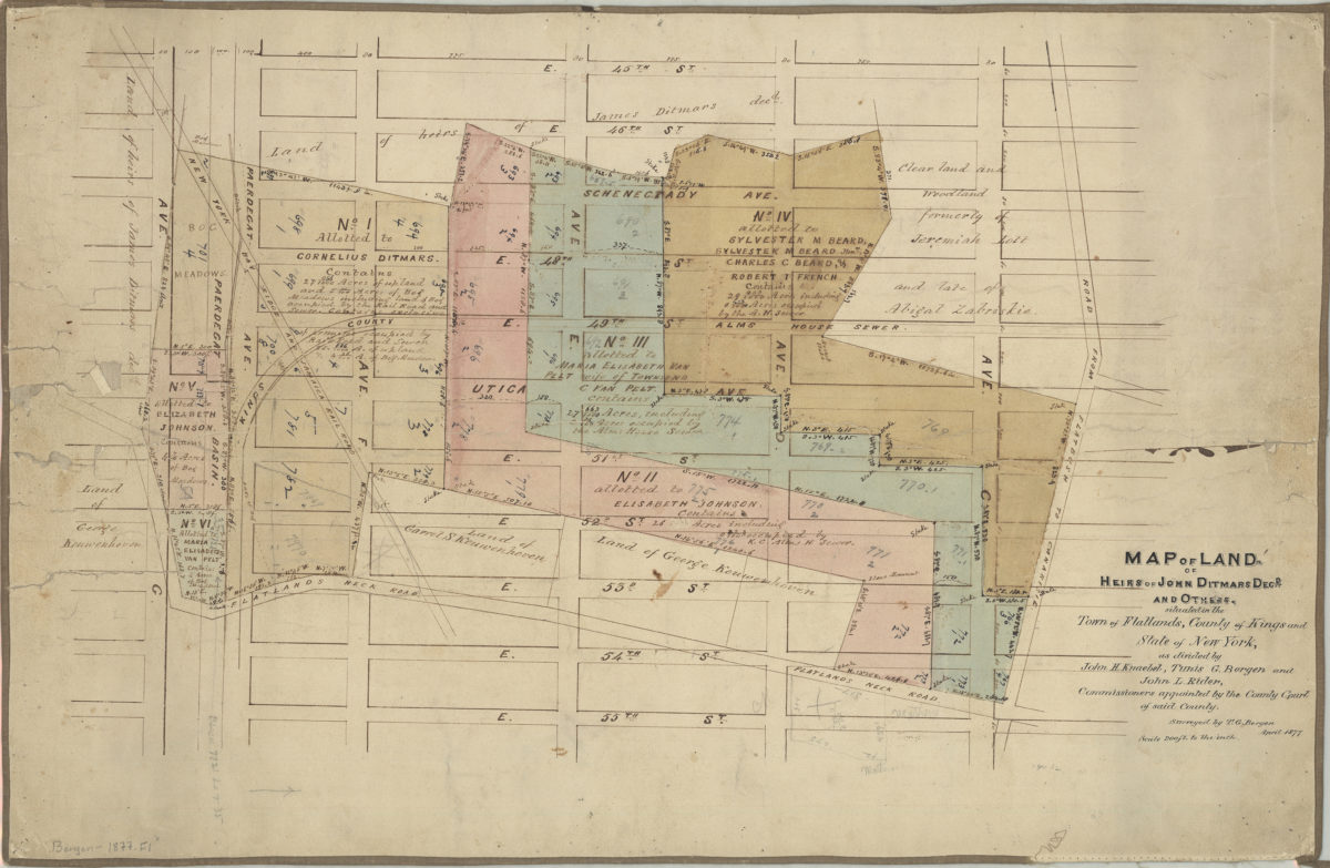
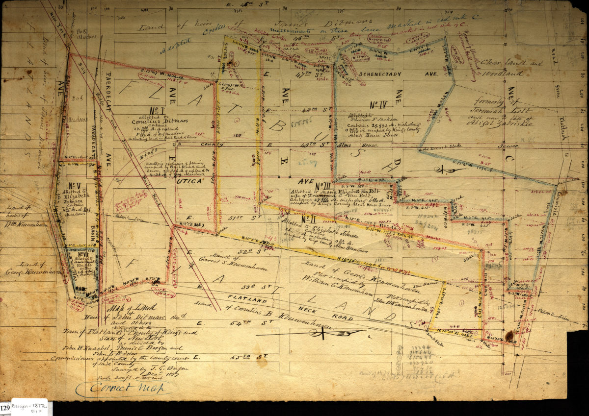
Map of land of heirs of John Ditmars, decd., and others: situated in the town of Flatlands, county of Kings and state of New York, as divided by John H. Knaebel, Tunis G. Bergen and John L. Rider, commissioners appointed by the County Court
Map of land of heirs of John Ditmars, decd., and others: situated in the town of Flatlands, county of Kings and state of New York, as divided by John H. Knaebel, Tunis G. Bergen and John L. Rider, commissioners appointed by the County Court
April 1877
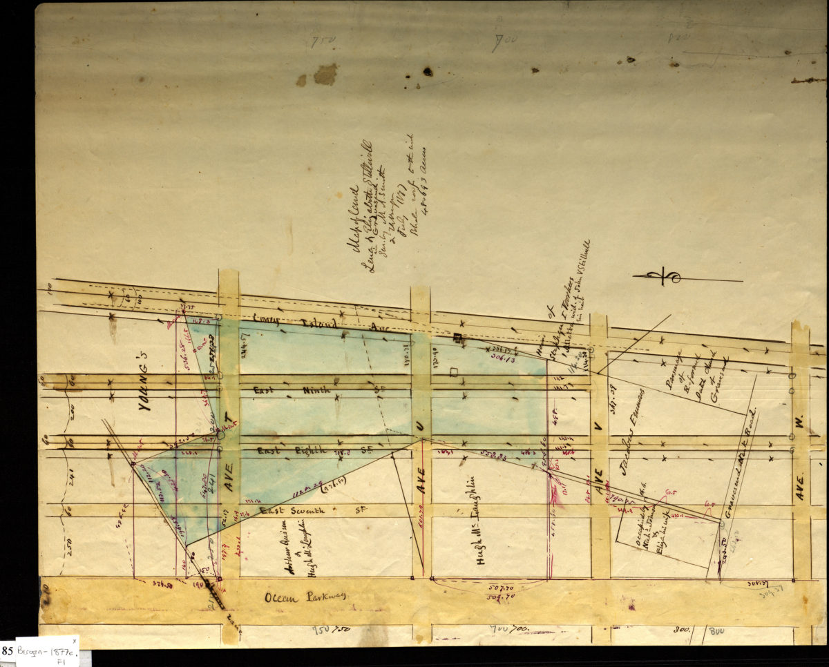
Map of land of Lena and Elizabeth Stillwell, formerly of Daniel I. Stillwell: situated in the town of Gravesend, county of Kings, state of New York, containing 23.953 acres ; as surveyed under the supervision of T.G. Bergen: by M.A. Smith
Map of land of Lena and Elizabeth Stillwell, formerly of Daniel I. Stillwell: situated in the town of Gravesend, county of Kings, state of New York, containing 23.953 acres ; as surveyed under the supervision of T.G. Bergen: by M.A. Smith
July 1877
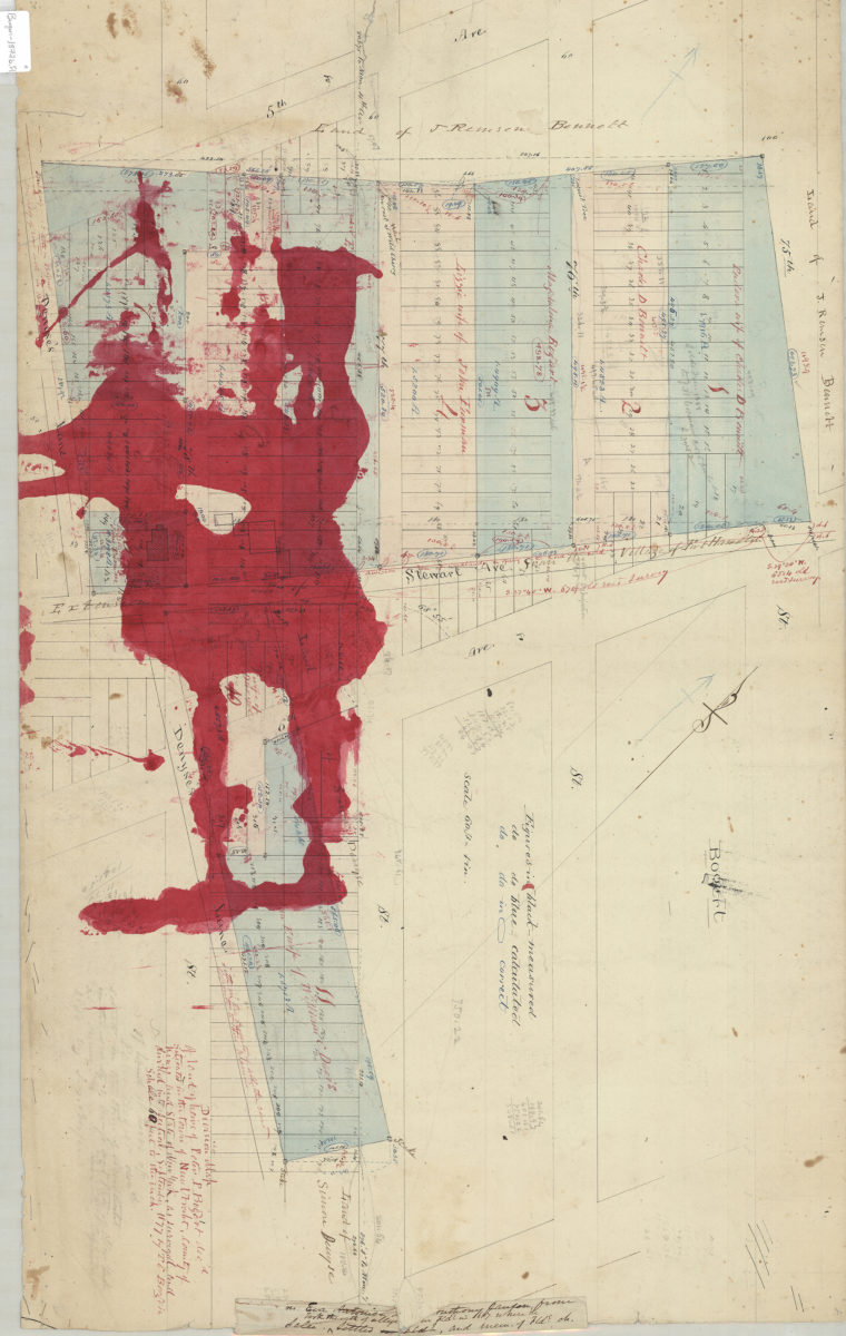
Division map of land of Peter P. Bogert, decd., situated in the town of New Utrecht, county of Kings, and state of New York, as surveyed and divided into sections: by T.G. Bergen
Division map of land of Peter P. Bogert, decd., situated in the town of New Utrecht, county of Kings, and state of New York, as surveyed and divided into sections: by T.G. Bergen
Sept. 1877
Map of land of heirs of John D. Ditmars, decd., and others, situated in the town of Flatlands in the county of Kings and … [text illegible] as divided by John H. Knaebel, Tunis G. Bergen, and John I. Ryder,
Map of land of heirs of John D. Ditmars, decd., and others, situated in the town of Flatlands in the county of Kings and … [text illegible] as divided by John H. Knaebel, Tunis G. Bergen, and John I. Ryder,
April 1877
Map of land of heirs of John Ditmars, dec[ease]d, and others, situated in the town of Flatlands and Flatbush, county of Kings and state of New York as divided by John H. Knaebel, Teunis G. Bergen, and John I. Ryder
Map of land of heirs of John Ditmars, dec[ease]d, and others, situated in the town of Flatlands and Flatbush, county of Kings and state of New York as divided by John H. Knaebel, Teunis G. Bergen, and John I. Ryder
December 1877
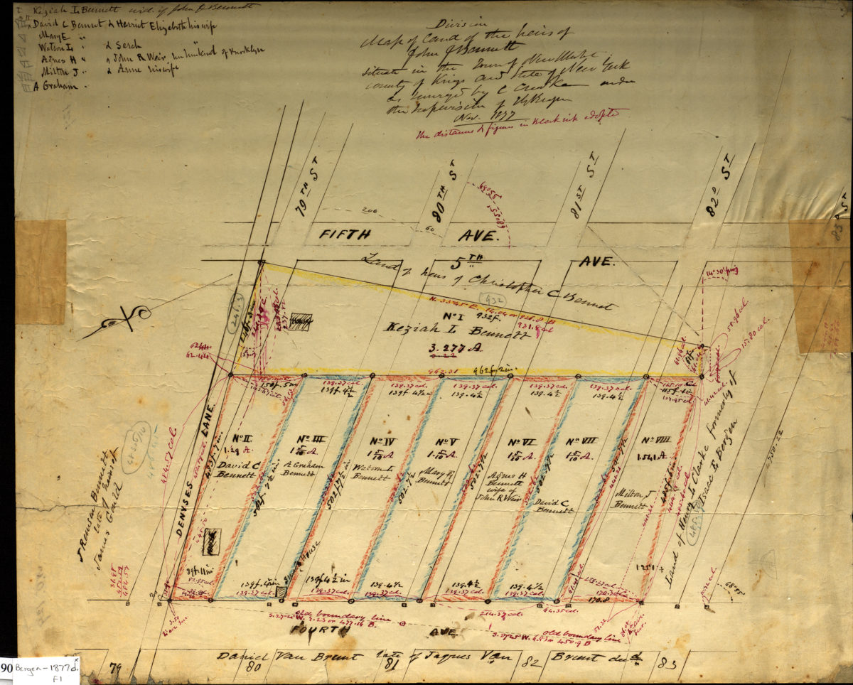
Division map of land of the heirs of John J. Bennett situated in the Town of New Utrecht, County of Kings in the State of New York: as surveyed by C. [text illegible] under the supervision of T. G. Bergen, Nov. 1877
Division map of land of the heirs of John J. Bennett situated in the Town of New Utrecht, County of Kings in the State of New York: as surveyed by C. [text illegible] under the supervision of T. G. Bergen, Nov. 1877
November 1877
Map of land [of] Lena & Elizabeth Stillwell in Gravesend, 48.693 acres: sur. by M.A. Smith & T.G. Bergen July 1877
Map of land [of] Lena & Elizabeth Stillwell in Gravesend, 48.693 acres: sur. by M.A. Smith & T.G. Bergen July 1877
July 1877
[Maps of land of heirs of Elizabeth Brainard, née Martense]
[Maps of land of heirs of Elizabeth Brainard, née Martense]
[ca. 1877]
Map of land of Lena & Elizabeth Stillwell, late of Daniel I. Stillwell, situated in the town of Gravesend, county of Kings & state of New York, containing 23.953 acres: as surveyed under the supervision of T. G. Bergen by M. A. Smith
Map of land of Lena & Elizabeth Stillwell, late of Daniel I. Stillwell, situated in the town of Gravesend, county of Kings & state of New York, containing 23.953 acres: as surveyed under the supervision of T. G. Bergen by M. A. Smith
[1877]
[Maps of land of Henry A. Kent, situated in the city of Brooklyn & town of New Utrecht, containing 61 4/10 acres exclusive of land in 3rd Avenue and including land in the other avenues & streets, and the plot conveyed to Susan Hopkins
[Maps of land of Henry A. Kent, situated in the city of Brooklyn & town of New Utrecht, containing 61 4/10 acres exclusive of land in 3rd Avenue and including land in the other avenues & streets, and the plot conveyed to Susan Hopkins
May 1877
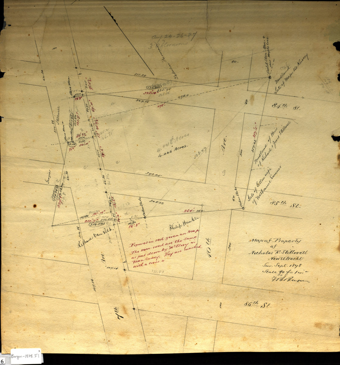
Map of property of Nicholas R. Stillwell, New Utrecht: V.B. Bergen
Map of property of Nicholas R. Stillwell, New Utrecht: V.B. Bergen
Sept. 1878
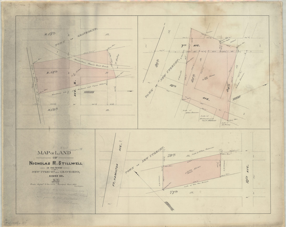
Map of land of Nicholas R. Stillwell in the towns of New Utrecht and Gravesend, Kings Co., N.Y.: surveyed Sept. 1878 [by] T.G. Bergen
Map of land of Nicholas R. Stillwell in the towns of New Utrecht and Gravesend, Kings Co., N.Y.: surveyed Sept. 1878 [by] T.G. Bergen
[1878]
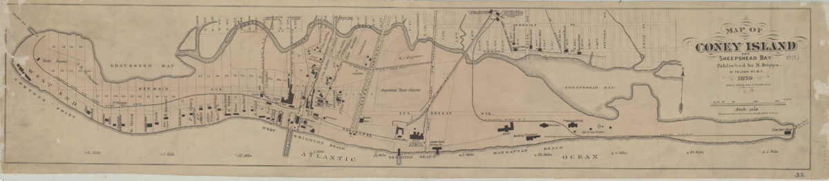
Map of Coney Island and Sheepshead Bay
Map of Coney Island and Sheepshead Bay
1879
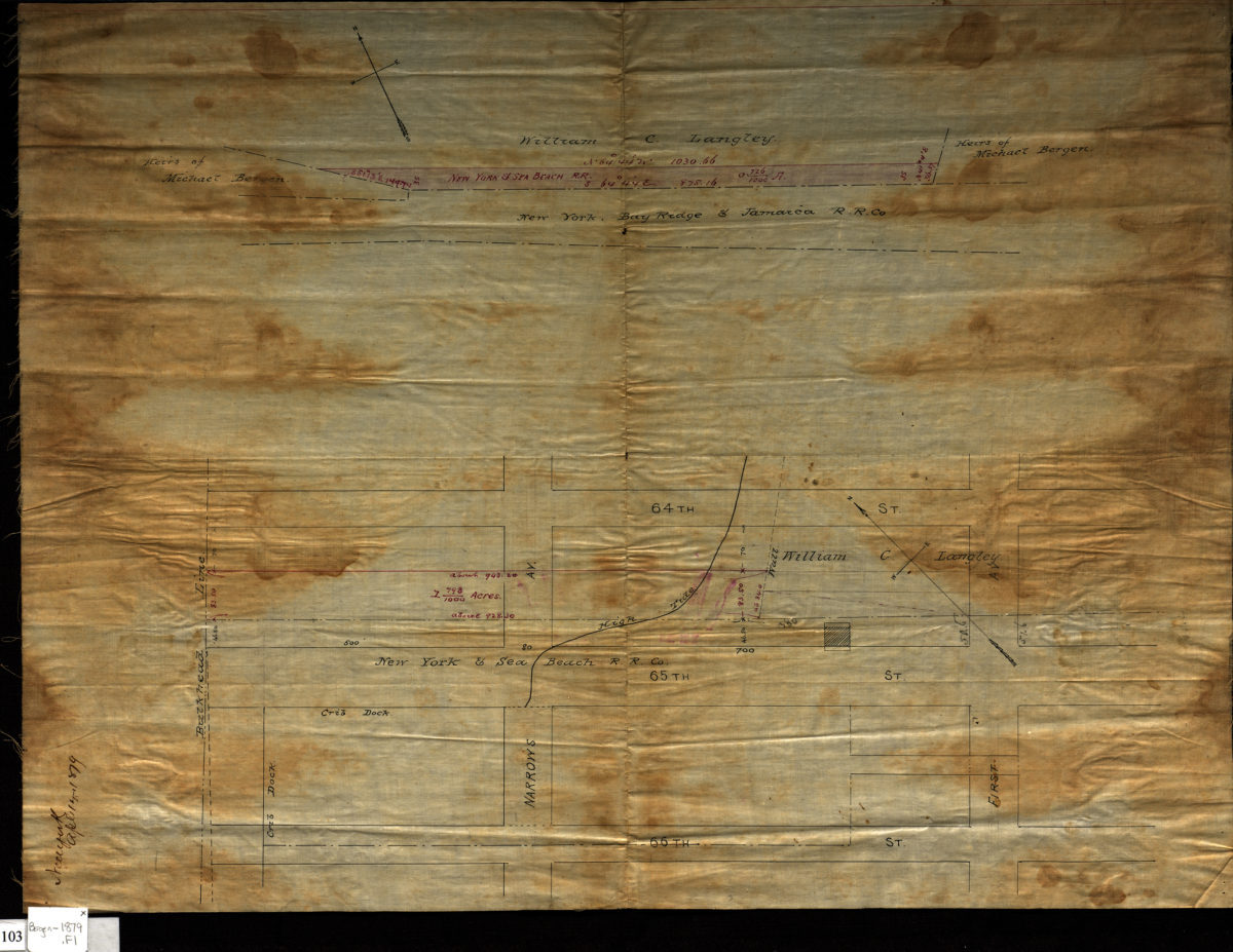
[Survey maps of New York & Sea Beach Railroad Company property in Bay Ridge]
[Survey maps of New York & Sea Beach Railroad Company property in Bay Ridge]
April 14, 1879
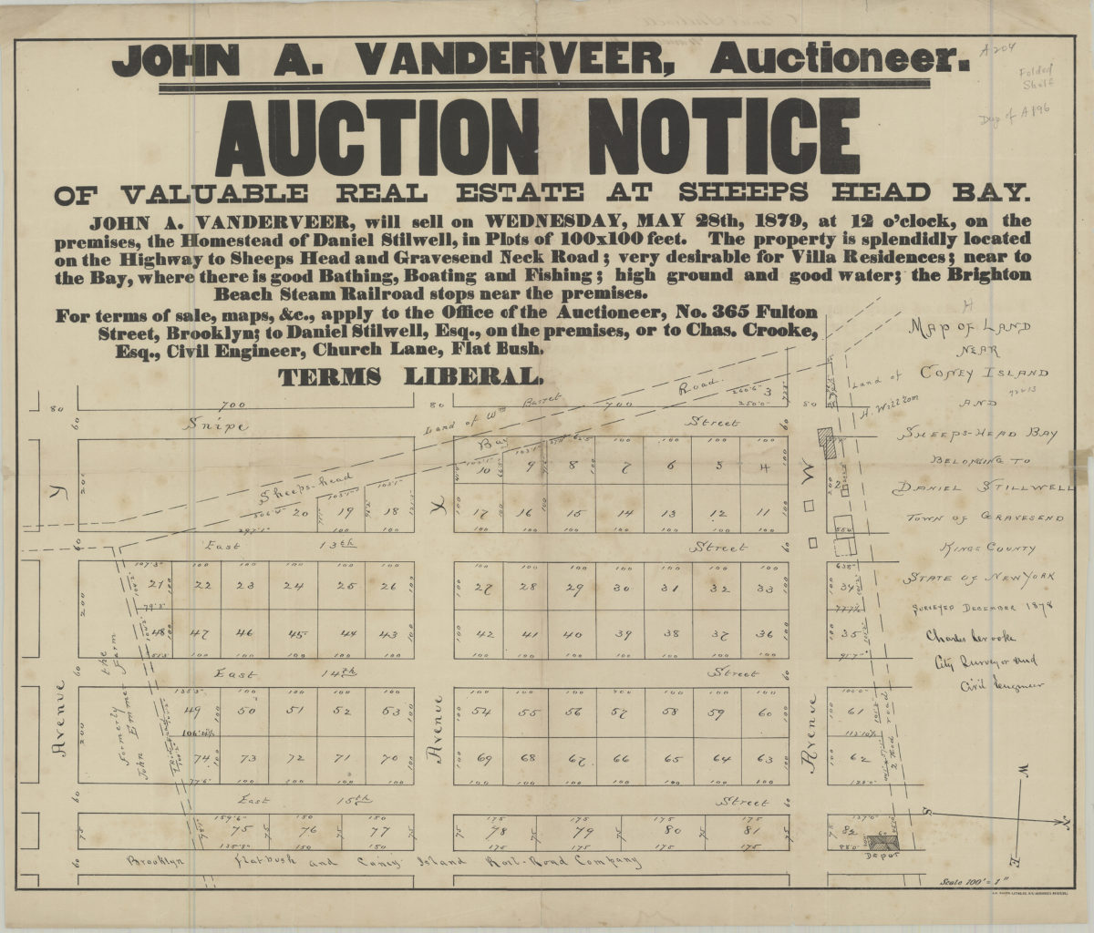
Auction notice of valuable real estate at Sheeps Head Bay
Auction notice of valuable real estate at Sheeps Head Bay
[1879]
Map of property of Mary Bullocke, wife of John Bullocke situated at Bay Ridge, Kings Co., New York: by T. G. Bergen, Jan. 1880
Map of property of Mary Bullocke, wife of John Bullocke situated at Bay Ridge, Kings Co., New York: by T. G. Bergen, Jan. 1880
January 1880
Previous
1
2
3
4
5
6
7
8
9
Next