Center for Brooklyn History
Map Collections
Search
About
Othmer Library & Archives
Submit search query
Refine 676 records
Clear filters
2
Location
Atlantic Basin (New York, N.Y.)
3
Bath Beach (New York, N.Y.)
8
Bay Ridge (New York, N.Y.)
108
Bay Ridge Park (New York, N.Y.)
1
Bedford-Stuyvesant (New York, N.Y.)
67
Bensonhurst (New York, N.Y.)
17
Blythebourne (New York, N.Y.)
1
Boerum Hill (New York, N.Y.)
6
Borough Park (New York, N.Y.)
23
Brighton Beach (New York, N.Y.)
4
Brooklyn (New York, N.Y.)
891
Brooklyn Heights (New York, N.Y.)
76
Brownsville (New York, N.Y.)
10
Buffalo (N.Y.)
3
Bushwick (New York, N.Y.)
20
Bushwick Park (New York, N.Y.)
1
Buttermilk Channel (New York, N.Y.)
1
Canarsie (New York, N.Y.)
18
Carroll Gardens (New York, N.Y.)
21
Carroll Park (New York, N.Y.)
1
Cemetery of the Evergreens (New York, N.Y.)
1
Clinton Hill (New York, N.Y.)
10
Cobble Hill (New York, N.Y.)
7
Commodore Barry Park (New York, N.Y.)
1
Coney Island (New York, N.Y.)
22
Cortelyou Farm (New York, N.Y.)
1
Cowenhoven Homestead (Brooklyn, New York, N.Y.)
1
Crown Heights (New York, N.Y.)
25
Cypress Hills (New York, N.Y.)
8
David Johnson Farm (New York, N.Y.)
1
Ditmas Park (New York, N.Y.)
1
Downtown Brooklyn (New York, N.Y.)
29
DUMBO Historic District (New York, N.Y.)
7
Dyker Heights (New York, N.Y.)
23
East Flatbush (New York, N.Y.)
23
East Midwood (New York, N.Y.)
1
East New York (New York, N.Y.)
16
East River (N.Y.)
3
Erasmus (New York, N.Y.)
1
Erie Basin (New York, N.Y.)
2
Farragut (New York, N.Y.)
1
Flatbush (New York, N.Y.)
35
Flatlands (New York, N.Y.)
19
Fort Brooklyn (New York, N.Y.)
1
Fort Greene (New York, N.Y.)
22
Fort Hamilton (New York, N.Y.)
31
Fulton Ferry Historic District (New York, N.Y.)
5
Futurama (New York, N.Y.)
2
Gowanus (New York, N.Y.)
12
Gowanus Bay (New York, N.Y.)
1
Gowanus Canal (New York, N.Y.)
5
Gravesend (New York, N.Y.)
25
Green-Wood Cemetery (New York, N.Y.)
2
Greenpoint (New York, N.Y.)
38
Herbert Von King Park (New York, N.Y.)
1
Hoboken (N.J.)
1
Hudson County (N.J.)
3
Jamaica Bay (N.Y.)
5
Jersey City (N.J.)
4
Kensington (New York, N.Y.)
11
Kings County (New York, N.Y.)
8
Kingslandville (New York, N.Y.)
1
Lefferts Park (New York, N.Y.)
1
Long Island (N.Y.)
197
Long Island, Battle of, New York, N.Y., 1776
4
Manhattan (New York, N.Y.)
120
Marine Park (New York, N.Y.)
5
Martense Farm (New York, N.Y.)
1
Marway Farm (New York, N.Y.)
1
Midwood (New York, N.Y.)
9
Monsignor Mcgolrick Park (New York, N.Y.)
1
Nassau County (N.Y.)
24
New Jersey
27
New Lots (New York, N.Y.)
1
New Utrecht (New York, N.Y.)
9
New York (N.Y.)
164
New York (State)
95
New York Harbor (N.Y. and N.J.)
16
New York Metropolitan Area
40
Newtown (New York, N.Y.)
1
Nottingham (New York, N.Y.)
2
Park Slope (New York, N.Y.)
16
Parkville (New York, N.Y.)
2
Pierrepont Homestead (New York, N.Y.)
6
Prospect Heights (New York, N.Y.)
16
Prospect Lefferts Gardens (Brooklyn, New York, N.Y.)
16
Prospect Park (New York, N.Y.)
25
Prospect Park South (New York, N.Y.)
8
Queens (New York, N.Y.)
83
Red Hook (New York, N.Y.)
19
Ridgewood (New York, N.Y.)
2
Rockaway (New York, N.Y.)
1
Sea Gate (New York, N.Y.)
7
Sewerage
1
Sheepshead Bay (New York, N.Y.)
13
South Brooklyn Temperance Village (Brooklyn, New York, N.Y.)
1
South Greenfield (New York, N.Y.)
1
Stuyvesant Heights (New York, N.Y.)
1
Sunset Park (New York, N.Y.)
53
United States
10
Upper Bay (N.Y. and N.J.)
4
Van Pelt Manor House (Brooklyn, New York, N.Y.)
1
Vinegar Hill Historic District (New York, N.Y.)
4
Wallabout Bay (New York, N.Y.)
6
Weeksville (New York, N.Y.)
7
Williamsburg (New York, N.Y.)
36
Windsor Terrace (New York, N.Y.)
10
Show 87 more
Subject
Apartment houses
1
Aqueducts
3
Auctions
32
Bays
5
Botanical gardens
2
Buildings
12
Canals
15
Cemeteries
17
Church property
1
Coasts
4
Decedents' estates
1
docks
2
Drainage
1
Election districts
36
Farms
2
ferries
32
Fills (Earthwork)
4
Fire alarms
4
Fire protection districts
2
Fortification
7
Gardens
1
Grading (Earthwork)
1
Harbors
11
Land grants
12
Land tenure
1
Landforms
15
Landowners
434
Long Island, Battle of, New York, N.Y. , 1776
7
Monorail railroads
1
Parks
35
Pavements
3
Piers
25
Planned communities
2
Ponds
6
Prisons
1
Public lands
1
Railroads
72
Railroads, Elevated
24
Real property
619
Reservoirs
2
Riparian rights
13
Rivers
16
Roads
117
Salt marshes
2
School districts
4
Schools
1
Sewerage
7
Shorelines
3
Storm sewers
2
Street railroads
8
Streets
46
Submerged lands
17
Swamps
2
Tenement houses
1
Tide-waters
2
Water-supply
3
Watersheds
5
Waterways
2
Waterworks
5
Wetlands
6
Wharves
1
Show 41 more
Date
19th Century
945
or enter range:
from
to
Genres
Advertisements
30
Aerial views
15
Bathymetric maps
94
Blueprints (reprographic copies)
1
Broadsides
33
Cadastral maps
597
Early maps
35
Historical maps
53
Lithographs
1
Manuscript maps
365
Map
191
Maps
6
Military maps
23
Nautical charts
30
Physical maps
4
Pictorial maps
38
Public utility maps
15
Road maps
83
Statistical maps
8
Thematic maps
60
Topographic maps
70
Tourist maps
55
Transportation maps
120
Zoning maps
55
Show 4 more
Sort by:
Date (earliest)
Date (most recent)
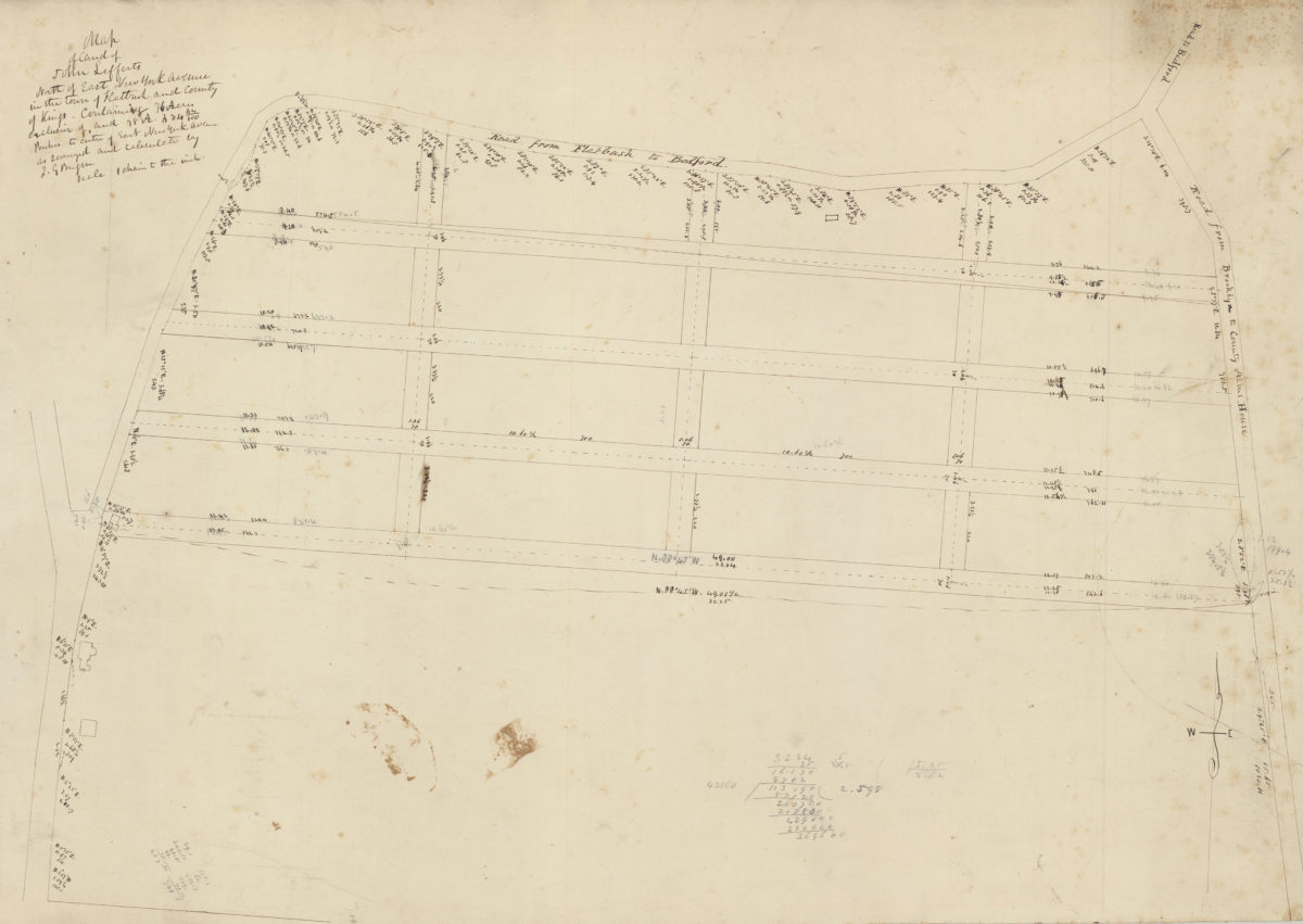
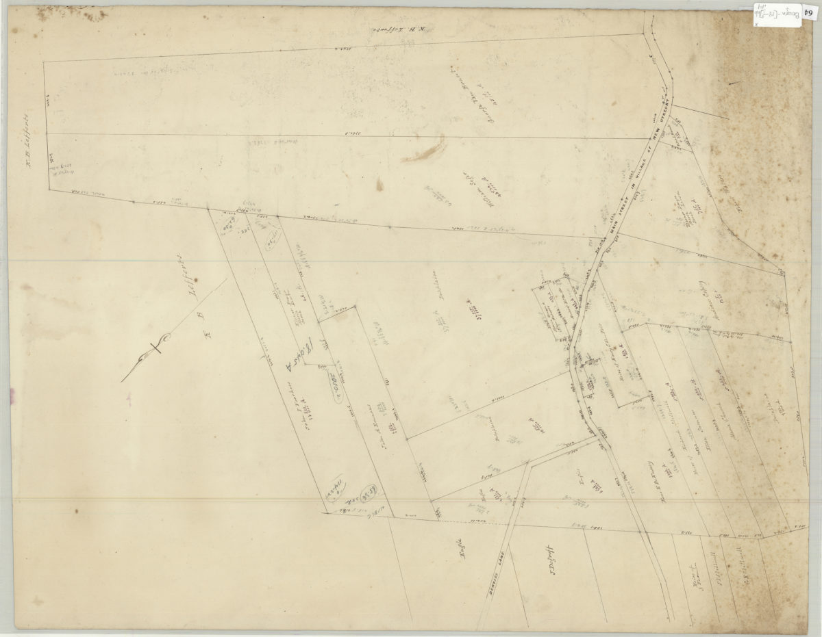
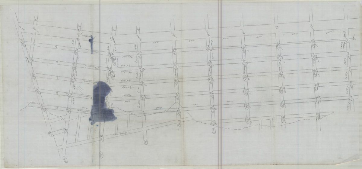
Map of land of John Lefferts, north of East New York Avenue in the town of Flatbush and county of Kings: containing 76 acres exclusive of, and 78 A. 234 64/100 perches to centre of East New York Avenue, as surveyed and calculated: by T.G. Bergen
Map of land of John Lefferts, north of East New York Avenue in the town of Flatbush and county of Kings: containing 76 acres exclusive of, and 78 A. 234 64/100 perches to centre of East New York Avenue, as surveyed and calculated: by T.G. Bergen
[18??]
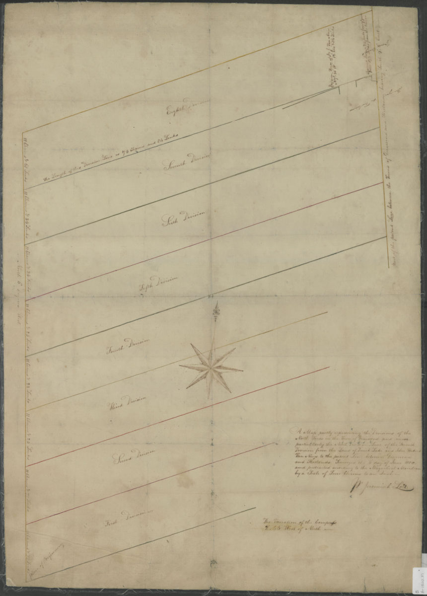
A map partly representing the divisions of the north woods in the town of Gravesend and more particularly the north division line of the seventh division from the land of Derick Lake and John Verkirk Van Nuys June, 1800
A map partly representing the divisions of the north woods in the town of Gravesend and more particularly the north division line of the seventh division from the land of Derick Lake and John Verkirk Van Nuys June, 1800
1800
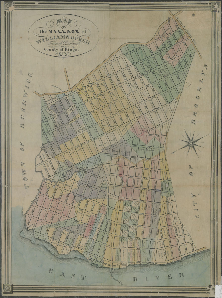
Map of the village of Williamsburgh, town of Bushwick, and county of Kings, L.I.
Map of the village of Williamsburgh, town of Bushwick, and county of Kings, L.I.
[18??]
[Survey maps of Flatlands]
[Survey maps of Flatlands]
[18??]
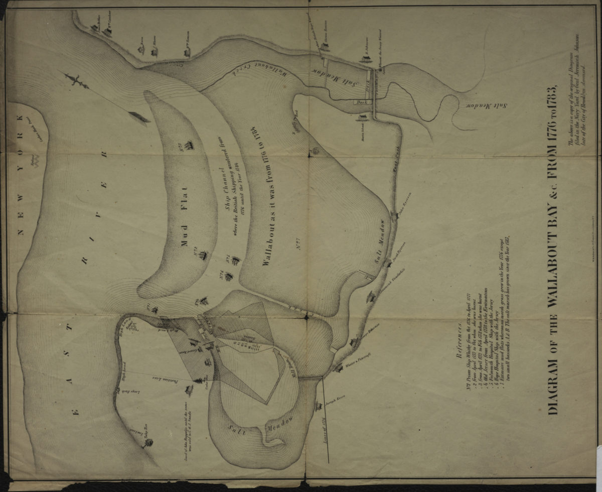
Diagram of the Wallabout Bay &c. from 1776 to 1783
Diagram of the Wallabout Bay &c. from 1776 to 1783
[18??]
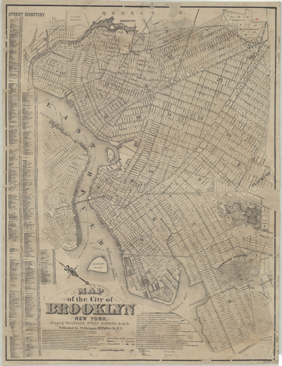
Map of the city of Brooklyn, New York: showing railroads, street numbers &c.&c.&c
Map of the city of Brooklyn, New York: showing railroads, street numbers &c.&c.&c
[18??]
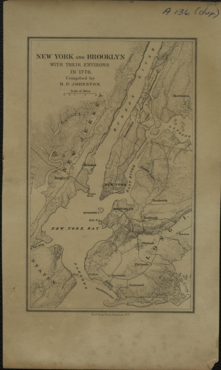
New York and Brooklyn with their environs in 1776: compiled by H.P. Johnston
New York and Brooklyn with their environs in 1776: compiled by H.P. Johnston
[18??]
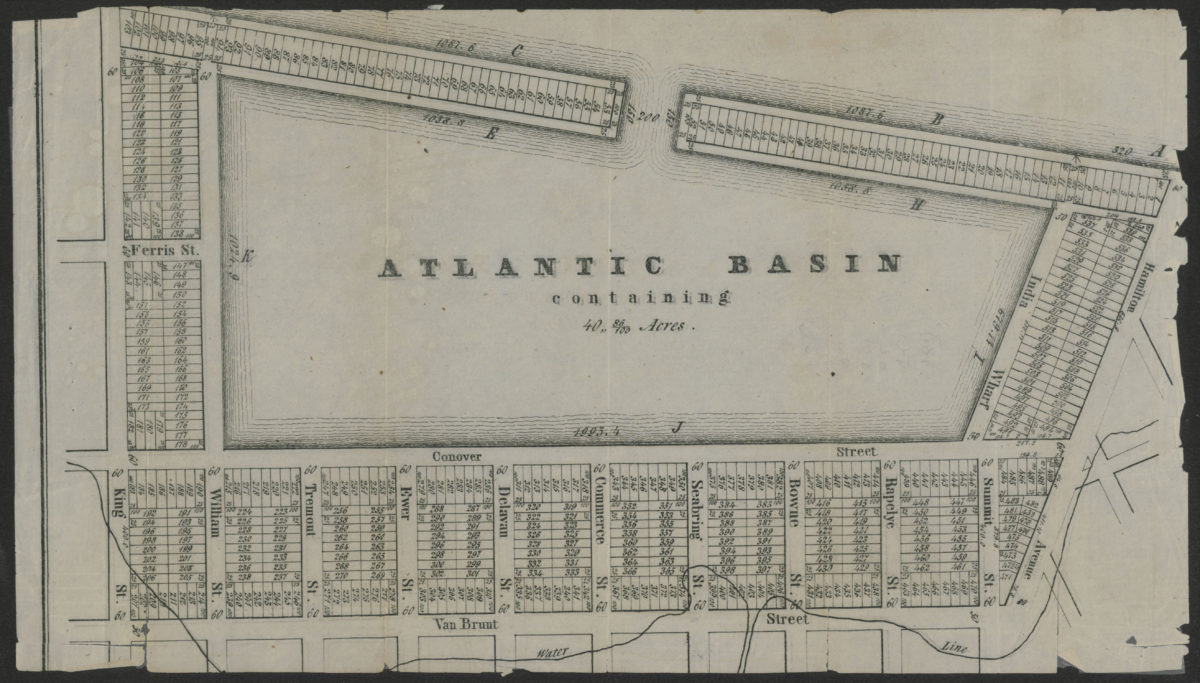
Atlantic Basin containing 40” 86/100 acres
Atlantic Basin containing 40” 86/100 acres
[18??]
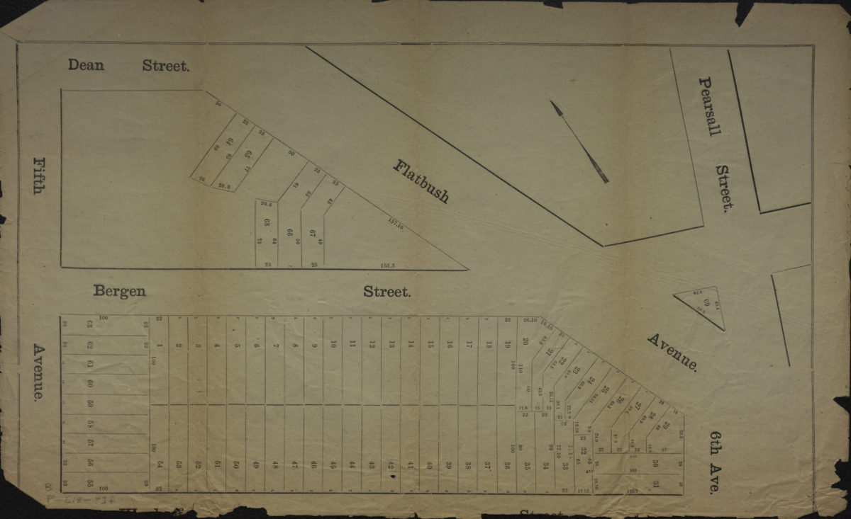
[Map of area bounded by 5th Ave., Dean St., Pearsall St., and Wyckoff St.].
[Map of area bounded by 5th Ave., Dean St., Pearsall St., and Wyckoff St.].
[18??]
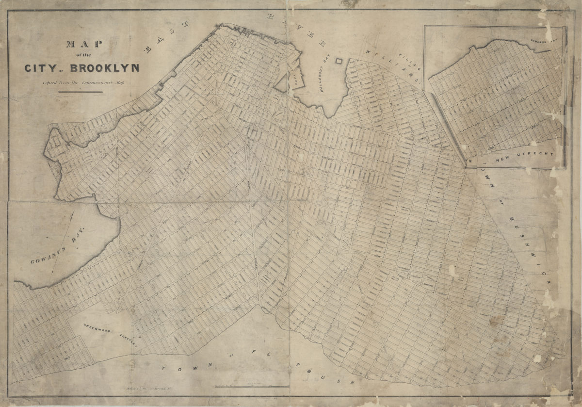
Map of the city of Brooklyn: copied from the Commissioner’s map
Map of the city of Brooklyn: copied from the Commissioner’s map
[18??]
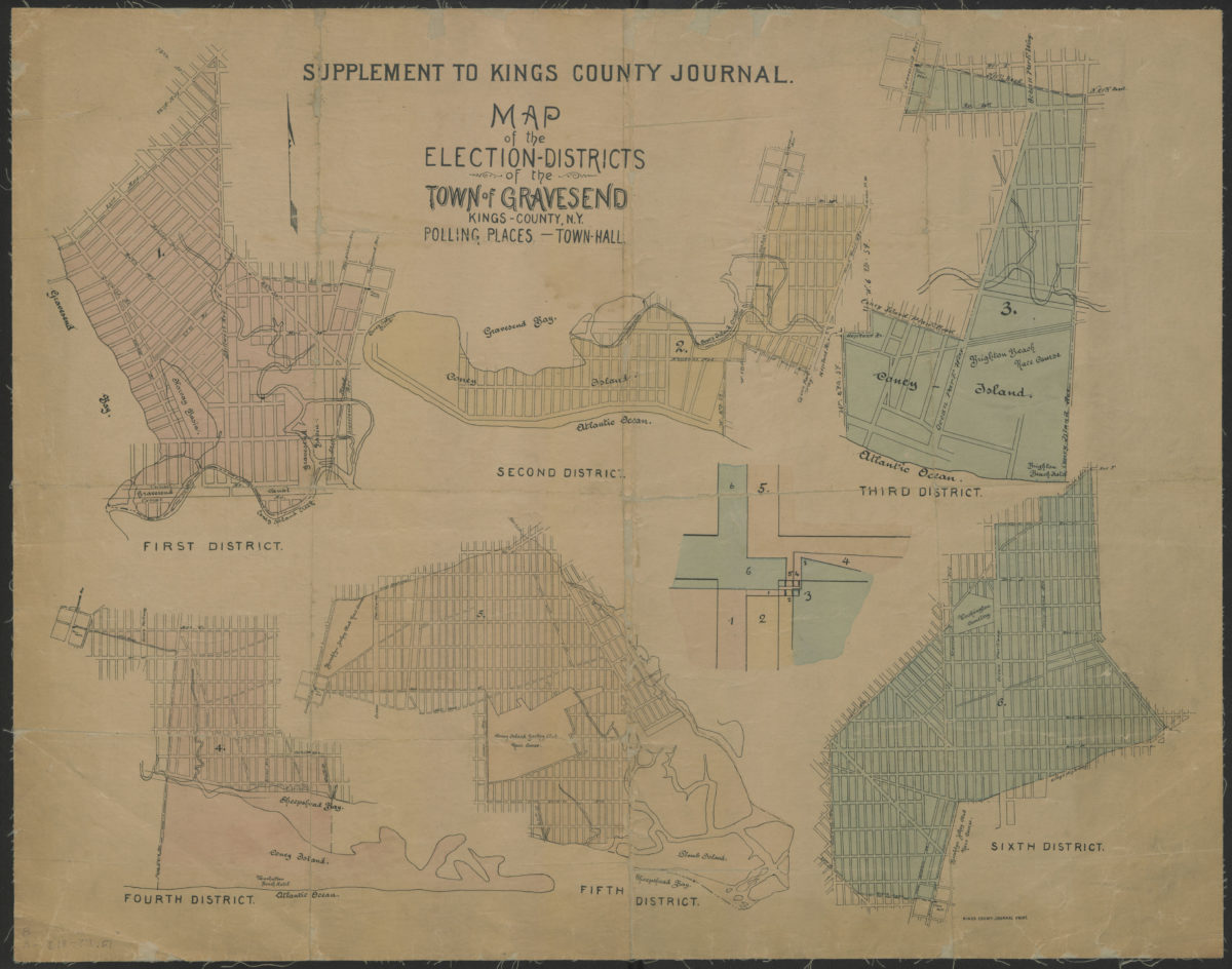
Map of the election districts of the Town of Gravesend, Kings County, N.Y., polling places, Town Hall
Map of the election districts of the Town of Gravesend, Kings County, N.Y., polling places, Town Hall
[18??]
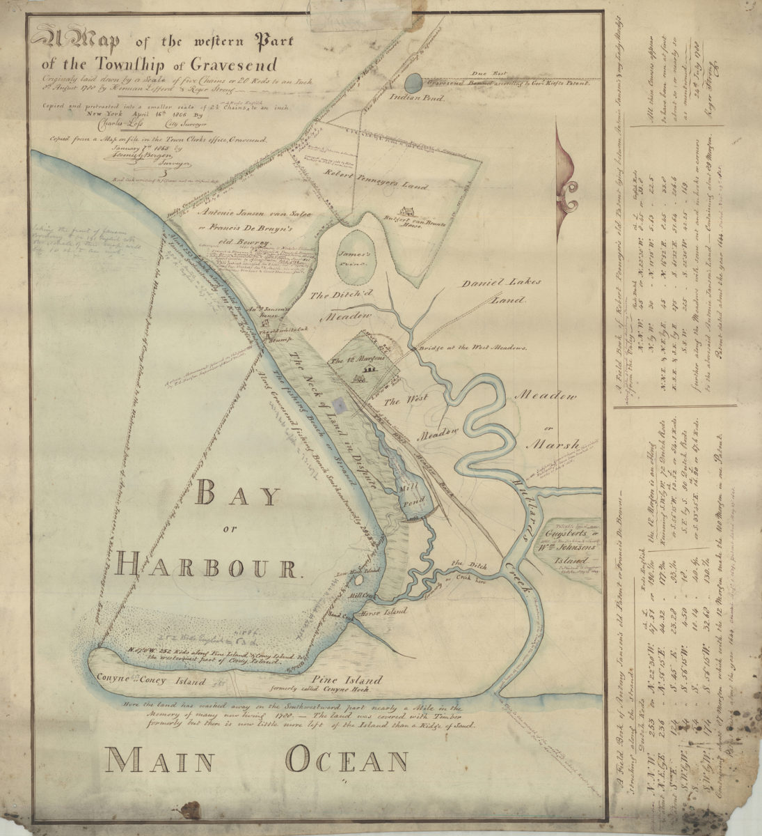
Map of the western part of the Township of Gravesend originally laid down by a scale of five chains or 20 rods to an inch, 8th August 1788 by Herman Lefford & Roger Strong: April 16th 1806
Map of the western part of the Township of Gravesend originally laid down by a scale of five chains or 20 rods to an inch, 8th August 1788 by Herman Lefford & Roger Strong: April 16th 1806
[18??]
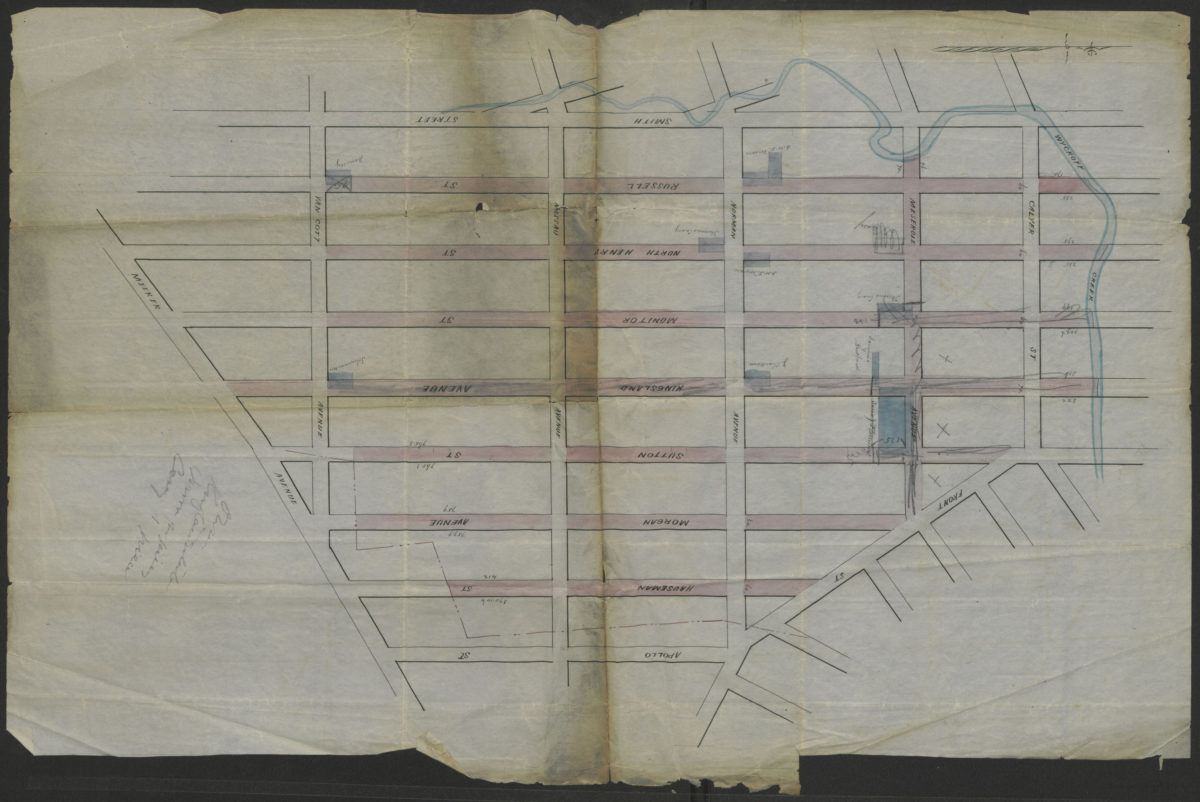
[Map showing street grid, existing buildings, and the course of Wykoff Creek in Greenpoint, Brooklyn]
[Map showing street grid, existing buildings, and the course of Wykoff Creek in Greenpoint, Brooklyn]
[18??]
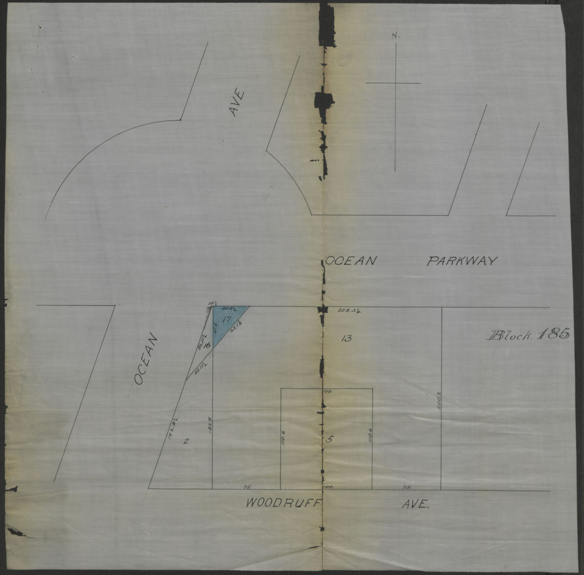
[Map showing property at intersection of Ocean Avenue and Ocean Parkway in Brooklyn, N.Y.]
[Map showing property at intersection of Ocean Avenue and Ocean Parkway in Brooklyn, N.Y.]
[18??]
[Map showing the intersection of Gowanus Creek with Gowanus Canal, Brooklyn, N.Y.]
[Map showing the intersection of Gowanus Creek with Gowanus Canal, Brooklyn, N.Y.]
[18??]
[Map of Dyker Meadows in the town of New Utrecht]
[Map of Dyker Meadows in the town of New Utrecht]
[18??]
[Land of John Lott at Flatbush Avenue and Montgomery Street]
[Land of John Lott at Flatbush Avenue and Montgomery Street]
[18??]
[Map of area bounded by 71st Street, 2nd Avenue, 74th Street, and 1st Avenue]
[Map of area bounded by 71st Street, 2nd Avenue, 74th Street, and 1st Avenue]
[18??]
[Map of area bounded by 31st Street, 8th Avenue, 40th Street and 2nd Avenue]
[Map of area bounded by 31st Street, 8th Avenue, 40th Street and 2nd Avenue]
[18??]
[Map of area bounded by 46th Street, 8th Avenue, 48th Street and 7th Avenue]
[Map of area bounded by 46th Street, 8th Avenue, 48th Street and 7th Avenue]
[18??]
Map of the western part of the Township of Gravesend originally laid down by a scale of five chains or 20 rods to an inch, 8th August 1788 by Herman Lefford & Roger Strong:New York City, April 16th 1806
Map of the western part of the Township of Gravesend originally laid down by a scale of five chains or 20 rods to an inch, 8th August 1788 by Herman Lefford & Roger Strong:New York City, April 16th 1806
[18??]
Sketch of New Utrecht from Dripps map
Sketch of New Utrecht from Dripps map
[18??]
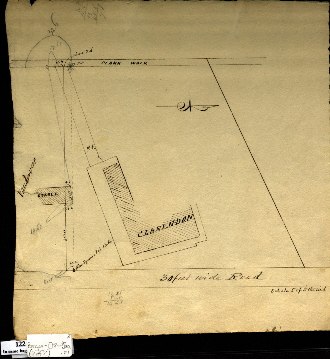
[Survey maps of Kings County Penitentiary Grounds and Vanderveer encroachment onto Clarendon property]
[Survey maps of Kings County Penitentiary Grounds and Vanderveer encroachment onto Clarendon property]
[18??]
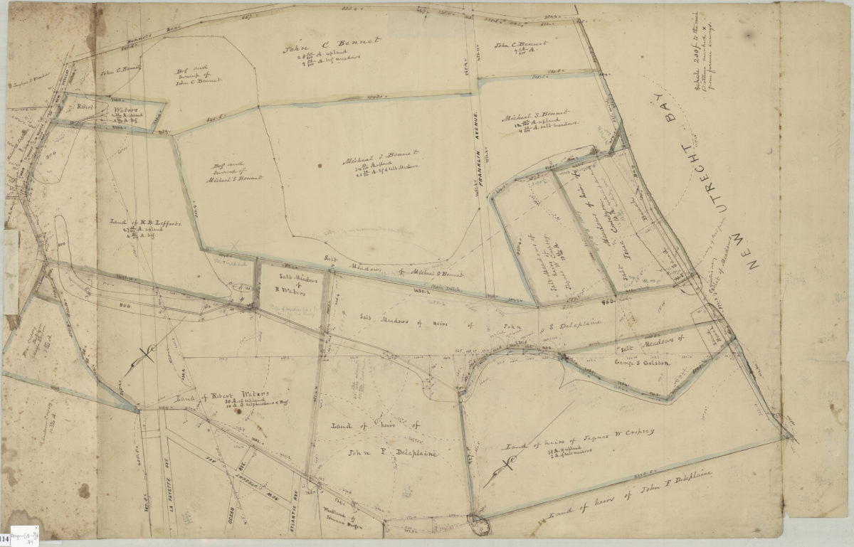
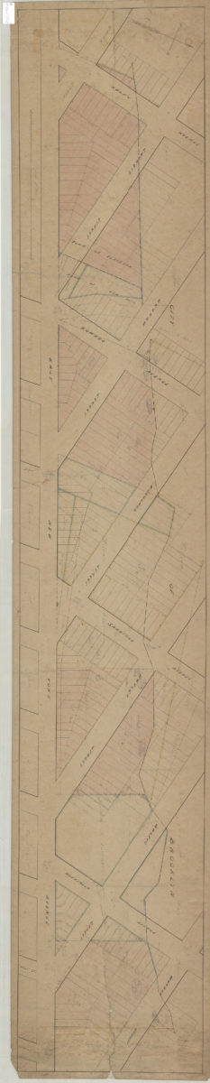
Land of G. Van Brunt, Sieger, Delaplaine, A. Cropsey & c
Land of G. Van Brunt, Sieger, Delaplaine, A. Cropsey & c
[18??]
Grades on street in Richards tract, Bay Ridge
Grades on street in Richards tract, Bay Ridge
[18??]
Opening map and tracing of 22nd Ave
Opening map and tracing of 22nd Ave
[18??]
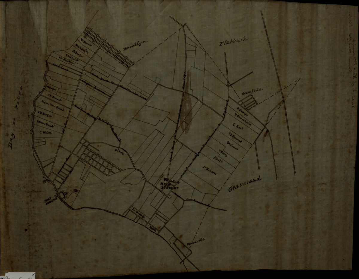
Map of territory near the Bay from the Village of New Utrecht to Gravesend & Coney Island
Map of territory near the Bay from the Village of New Utrecht to Gravesend & Coney Island
[18??]
Map of Bay Ridge
Map of Bay Ridge
[18??]
[Map of area around Gowanus Creek]: surveyed 6th April 1750 by Fran Maerschalck, copied by T. G. Bergen from the original in the possession of John Martense
[Map of area around Gowanus Creek]: surveyed 6th April 1750 by Fran Maerschalck, copied by T. G. Bergen from the original in the possession of John Martense
[18??]
Draft of extension of Ovington Ave
Draft of extension of Ovington Ave
[18??]
92nd St
92nd St
[18??]
[Map of land near Avenue E, East 52nd Street, Avenue D and East 54th Street in the Town of Flatlands]
[Map of land near Avenue E, East 52nd Street, Avenue D and East 54th Street in the Town of Flatlands]
[18??]
Schermerhorn & Pope adjoining Greenwood Cemetery
Schermerhorn & Pope adjoining Greenwood Cemetery
[18??]
[Grade maps for Richard R. Bennet]
[Grade maps for Richard R. Bennet]
[18??]
[Survey map of Coney Island and Gravesend]
[Survey map of Coney Island and Gravesend]
[18??]
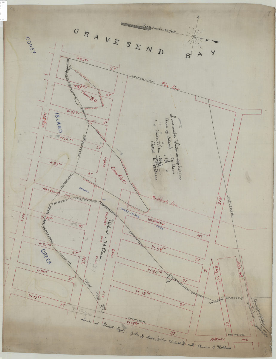
[Map of area bounded by Bay 49th St., W. 28th St., Neptune Ave. and W. 18th St.].
[Map of area bounded by Bay 49th St., W. 28th St., Neptune Ave. and W. 18th St.].
[18??]
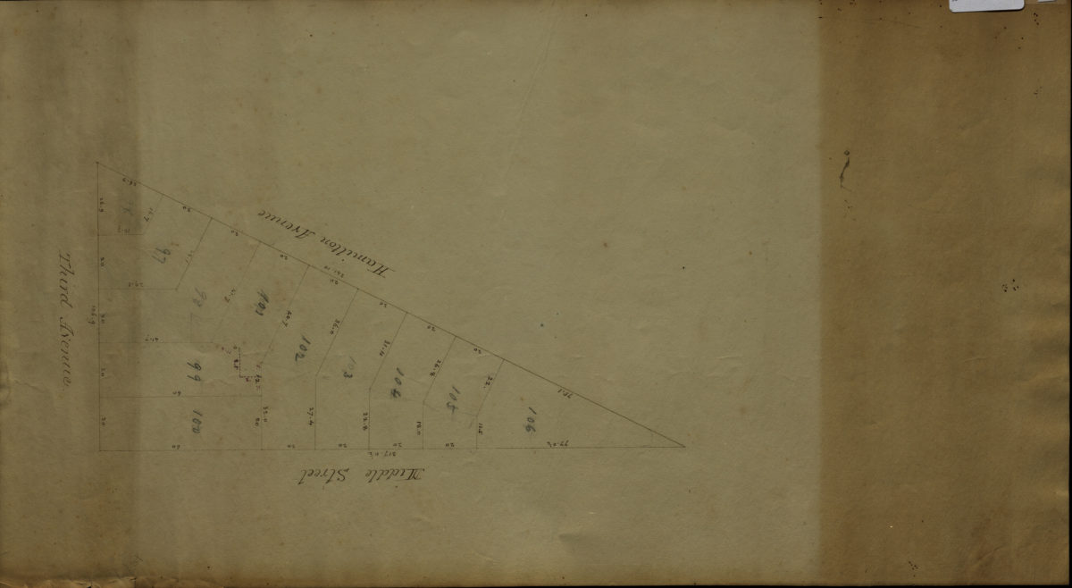
[Map of area bounded by Middle St., Hamilton Ave., and 3rd Ave.].
[Map of area bounded by Middle St., Hamilton Ave., and 3rd Ave.].
[18??]
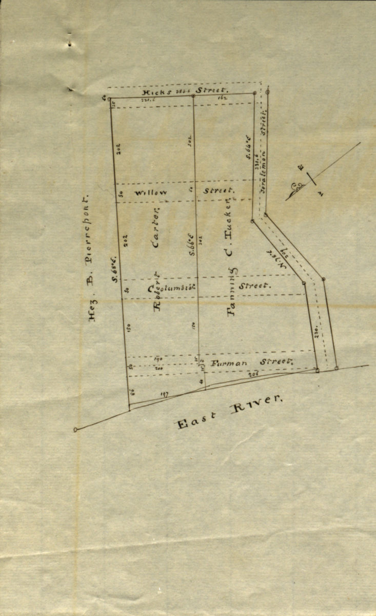
[Map showing land of Robert Carter, Fanning C. Tucker, and Hez. B. Pierrepont]
[Map showing land of Robert Carter, Fanning C. Tucker, and Hez. B. Pierrepont]
[18??]
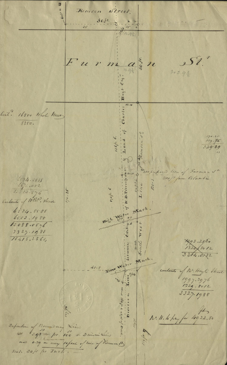
[Map of Remsen St. and Furman St.].
[Map of Remsen St. and Furman St.].
[18??]
[Map of area bounded by Franklin Ave., Sullivan Pl., Albany Ave., and Eastern Pkwy]
[Map of area bounded by Franklin Ave., Sullivan Pl., Albany Ave., and Eastern Pkwy]
[18??]
[Map covering area north from E. 93rd St. to Douglass St. and east from East New York Ave. to Flatlands Ave.].
[Map covering area north from E. 93rd St. to Douglass St. and east from East New York Ave. to Flatlands Ave.].
[18??]
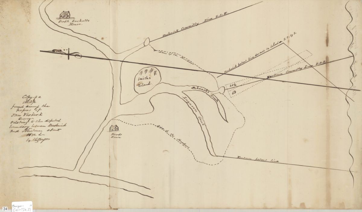
Copy of a map found among the papers of Jan Verkerk, surveyor, relating to the disputed boundary between Bushwick and Newtown about 1672: by T.G. Bergen
Copy of a map found among the papers of Jan Verkerk, surveyor, relating to the disputed boundary between Bushwick and Newtown about 1672: by T.G. Bergen
[18??]
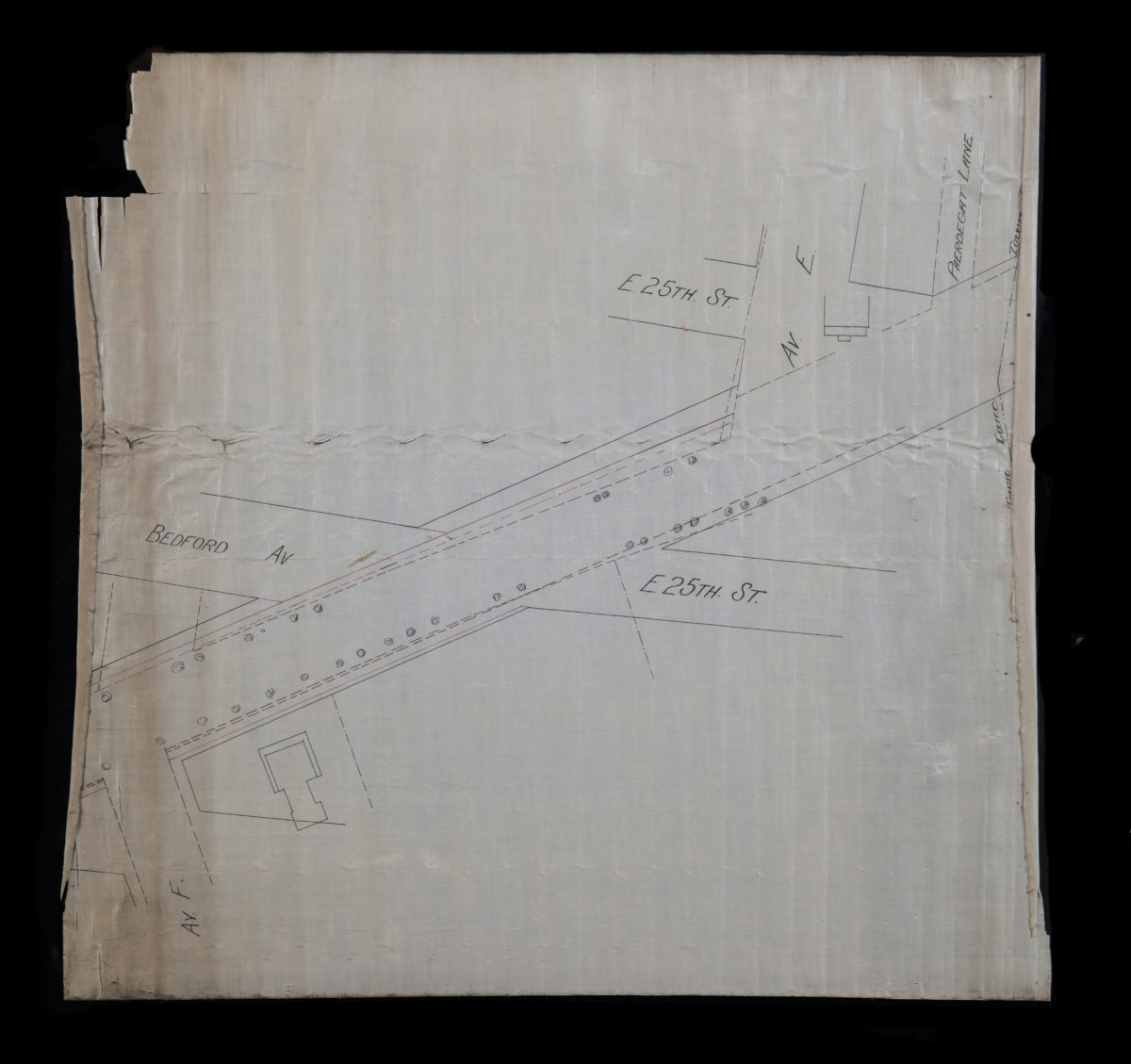
[Map of E. 25th St. and Bedford Ave. between Ave. F and Paerdegat Ln]
[Map of E. 25th St. and Bedford Ave. between Ave. F and Paerdegat Ln]
[18??]
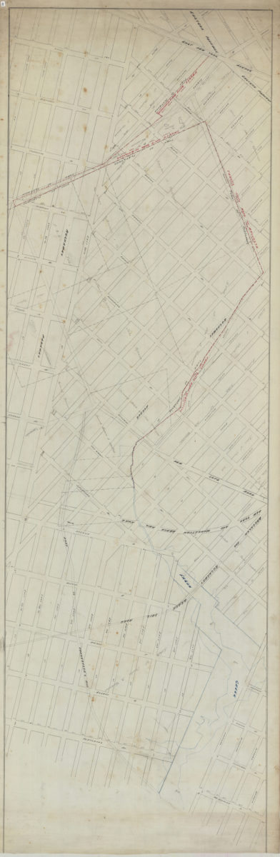
[Map of East New York Ave.].
[Map of East New York Ave.].
[18??]
[Map of Church Ave. between E. 18th St. and Nostrand Ave.].
[Map of Church Ave. between E. 18th St. and Nostrand Ave.].
[18??]
Plan of the Battle of Long Island and of the Brooklyn defences, August 27th, 1776: compiled by Henry P. Johnston ; F. von Egloffstein, del
Plan of the Battle of Long Island and of the Brooklyn defences, August 27th, 1776: compiled by Henry P. Johnston ; F. von Egloffstein, del
[18??]
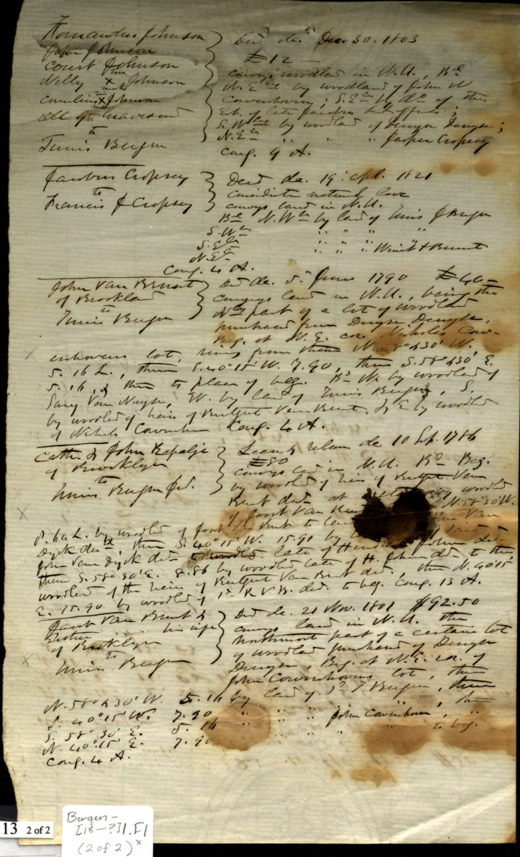
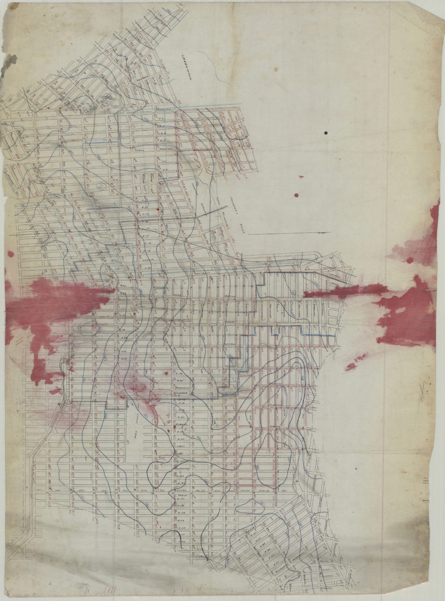
[Map of land ownership in 18th century Brooklyn]
[Map of land ownership in 18th century Brooklyn]
[18??]
[Map covering area east from Greenwood Cemetery to Howard Ave. and north from Ave G. to Eastern Pkwy]
[Map covering area east from Greenwood Cemetery to Howard Ave. and north from Ave G. to Eastern Pkwy]
[18??]
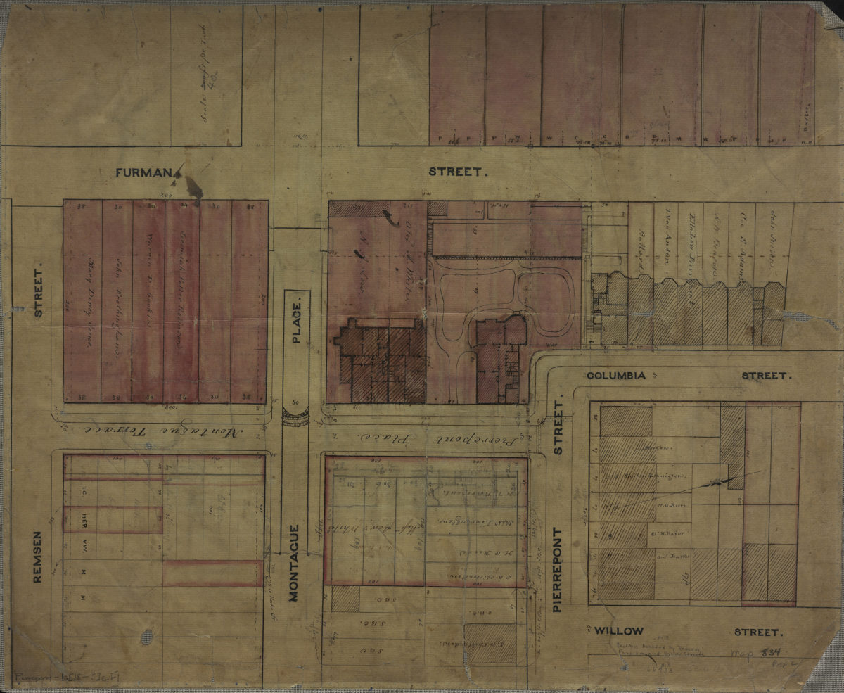
[Map of area bounded by Furman St., Remsen St., and Willow St.].
[Map of area bounded by Furman St., Remsen St., and Willow St.].
[18??]
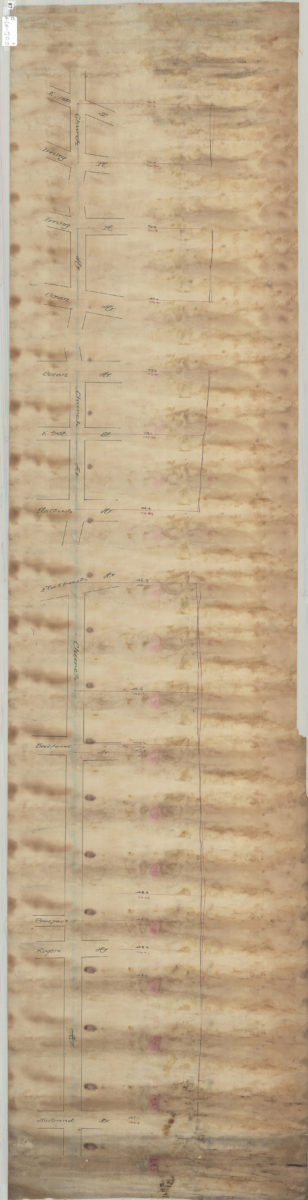
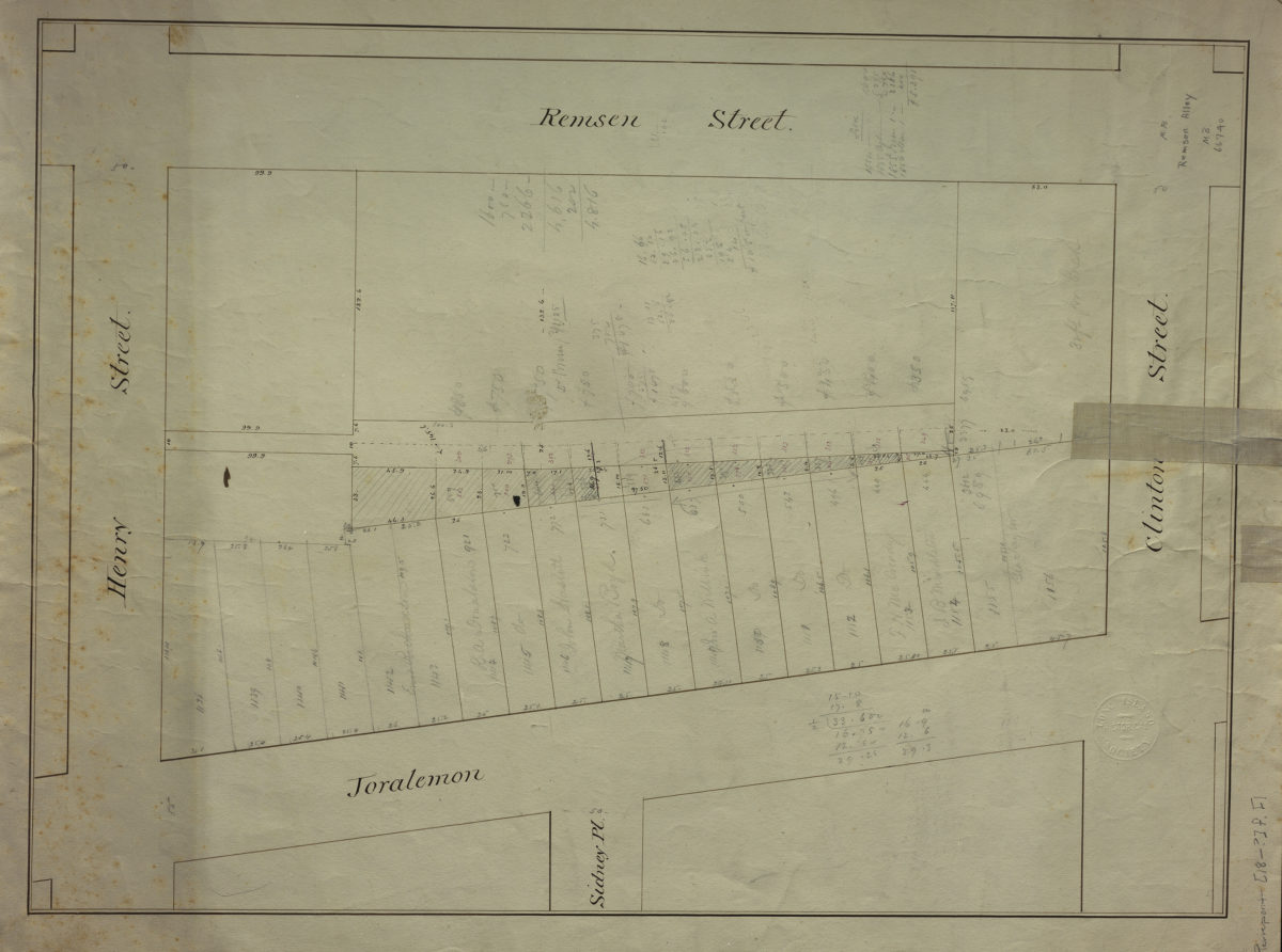
Remsen Alley
Remsen Alley
[18??]
1
2
3
4
5
6
7
8
9
10
11
12
13
14
Next