Center for Brooklyn History
Map Collections
Search
About
Othmer Library & Archives
Submit search query
Refine 945 records
Clear filter
1
Location
Abingdon Square (New York, N.Y.)
1
Adirondack Mountains (N.Y.)
2
Adirondack Park (N.Y.)
1
Albany (N.Y.)
3
Albany County (N.Y.)
1
Albion (Oswego County : Town)
1
Annastown (N.Y.)
1
Astoria (New York, N.Y.)
4
Atlantic Basin (New York, N.Y.)
3
Atlantic Coast (North America)
6
Atlantic Ocean.
1
Atlantic States
2
Auburn (N.Y.)
1
Babylon (N.Y. : Town)
2
Bath Beach (New York, N.Y.)
8
Battery Park (New York, N.Y.)
3
Bay Ridge (New York, N.Y.)
108
Bay Ridge Park (New York, N.Y.)
1
Bedford-Stuyvesant (New York, N.Y.)
67
Bellerose (New York, N.Y.)
1
Bensonhurst (New York, N.Y.)
17
Bergen County (N.J.)
6
Block Island (R.I. : Island)
2
Blythebourne (New York, N.Y.)
1
Boerum Hill (New York, N.Y.)
6
Borough Park (New York, N.Y.)
23
Boylston (N.Y.)
1
Brandon (N.Y.)
1
Bridgehampton (N.Y.)
1
Brighton Beach (New York, N.Y.)
4
Brookhaven (N.Y. : Town)
3
Brookhaven (N.Y.)
2
Brooklyn (New York, N.Y.)
891
Brooklyn Heights (New York, N.Y.)
76
Brownsville (New York, N.Y.)
10
Buffalo (N.Y.)
3
Bushwick (New York, N.Y.)
20
Bushwick Park (New York, N.Y.)
1
Buttermilk Channel (New York, N.Y.)
1
Canarsie (New York, N.Y.)
18
Caribbean Area
2
Carroll Gardens (New York, N.Y.)
21
Carroll Park (New York, N.Y.)
1
Cemetery of the Evergreens (New York, N.Y.)
1
Central Park (New York, N.Y.)
3
Champlain Canal (N.Y.)
1
City Hall Park (New York, N.Y.)
1
Clermont (N.Y. : Town)
1
Clinton County (N.Y.)
1
Clinton Hill (New York, N.Y.)
10
Cobble Hill (New York, N.Y.)
7
College Point (New York, N.Y.)
2
Columbus Park (New York, N.Y.)
1
Commodore Barry Park (New York, N.Y.)
1
Coney Island (New York, N.Y.)
22
Connecticut
7
Connecticut River
1
Constable (N.Y.)
1
Corona (New York, N.Y.)
2
Cortelyou Farm (New York, N.Y.)
1
Cowenhoven Homestead (Brooklyn, New York, N.Y.)
1
Croton Aqueduct (N.Y.)
3
Croton River Watershed (N.Y.)
2
Crown Heights (New York, N.Y.)
25
Cypress Hills (New York, N.Y.)
8
David Johnson Farm (New York, N.Y.)
1
Delaware River Valley (N.Y.-Del. and N.J.)
1
Denmark (N.Y.)
1
Dickinson (N.Y.)
2
Ditmas Park (New York, N.Y.)
1
Douglaston (New York, N.Y.)
1
Downtown Brooklyn (New York, N.Y.)
29
Duane Street Park (New York, N.Y.)
1
DUMBO Historic District (New York, N.Y.)
7
Dunkirk (N.Y.)
1
Dutchess County (N.Y.)
2
Dyker Heights (New York, N.Y.)
23
East Elmhurst (New York, N.Y.)
2
East Flatbush (New York, N.Y.)
23
East Harlem (New York, N.Y.)
1
East Midwood (New York, N.Y.)
1
East New York (New York, N.Y.)
16
East Patchogue (N.Y.)
1
East River (N.Y.)
3
Erasmus (New York, N.Y.)
1
Erie Basin (New York, N.Y.)
2
Erie Canal (N.Y.)
3
Erie County (N.Y.)
1
Essex County (N.J.)
4
Fairfield County (Conn.)
5
Far Rockaway (New York, N.Y.)
2
Farragut (New York, N.Y.)
1
Flatbush (New York, N.Y.)
35
Flatlands (New York, N.Y.)
19
Flushing (New York, N.Y.)
13
Fort Brooklyn (New York, N.Y.)
1
Fort Covington (N.Y.)
1
Fort Greene (New York, N.Y.)
22
Fort Hamilton (New York, N.Y.)
31
Fort Stanwix (Rome, N.Y.)
1
Fort Washington (New York, N.Y.)
2
Franklin County (N.Y.)
2
Freeport (N.Y.)
1
Fulton Ferry Historic District (New York, N.Y.)
5
Futurama (New York, N.Y.)
2
Genesee County (N.Y.)
2
Genesee River (Pa. and N.Y.)
1
Germantown (N.Y. : Town)
1
Glen Cove (N.Y.)
1
Gowanus (New York, N.Y.)
12
Gowanus Bay (New York, N.Y.)
1
Gowanus Canal (New York, N.Y.)
5
Gramercy Park (New York, N.Y.)
1
Gravesend (New York, N.Y.)
25
Great Neck (N.Y.)
3
Green-Wood Cemetery (New York, N.Y.)
2
Greenboro (N.Y.)
1
Greenpoint (New York, N.Y.)
38
Greenport (N.Y.)
1
Greenwood (New York, N.Y.)
1
Harrisburgh (N.Y.)
1
Hempstead (N.Y.)
13
Herbert Von King Park (New York, N.Y.)
1
Hicksville (N.Y.)
1
Hinsdale (New York, N.Y.)
1
Hoboken (N.J.)
1
Hudson County (N.J.)
3
Hudson River (N.Y. and N.J.)
7
Hunters Point (New York, N.Y.)
2
Huntington (N.Y.)
7
Islip (N.Y.)
5
Jamaica (New York, N.Y.)
8
Jamaica Bay (N.Y.)
5
Jefferson County (N.Y.)
1
Jersey City (N.J.)
4
Kensington (New York, N.Y.)
11
Kings County (New York, N.Y.)
8
Kingslandville (New York, N.Y.)
1
Lakeland (N.Y.)
1
Lawrence Beach (N.Y.)
1
Lefferts Park (New York, N.Y.)
1
Lewis County (N.Y.)
2
Livingston (N.Y. : Town)
1
Livingston County (N.Y.)
1
Long Island (N.Y.)
197
Long Island City (New York, N.Y.)
8
Long Island Sound (N.Y. and Conn.)
12
Long Island, Battle of, New York, N.Y., 1776
4
Lorraine (N.Y.)
1
Madison Square Park (New York, N.Y.)
1
Manhattan (New York, N.Y.)
120
Marine Park (New York, N.Y.)
5
Maritime Provinces
1
Martense Farm (New York, N.Y.)
1
Martinsburg (N.Y.)
1
Marway Farm (New York, N.Y.)
1
Maspeth (New York, N.Y.)
2
Mattituck (N.Y.)
1
Middle Atlantic States
2
Middlesex County (N.J.)
4
Midwood (New York, N.Y.)
9
Miller Place (N.Y.)
1
Mineola (N.Y.)
1
Mohawk River Valley (N.Y.)
3
Monmouth County (N.J.)
3
Monsignor Mcgolrick Park (New York, N.Y.)
1
Montauk (N.Y.)
4
Morningside Heights (New York, N.Y.)
1
Morris County (N.J.)
3
Napeague Bay (N.Y.)
1
Nassau County (N.Y.)
24
New England
8
New France
1
New Jersey
27
New Lots (New York, N.Y.)
1
New Netherland
2
New Utrecht (New York, N.Y.)
9
New York (N.Y.)
164
New York (State)
95
New York Harbor (N.Y. and N.J.)
16
New York Metropolitan Area
40
New York Region
5
Newport County (R.I.)
1
Newtown (New York, N.Y.)
1
Newtown (Queens County, N.Y.)
4
North America
7
North Hempstead (N.Y. : Town)
4
Northport Bay (N.Y. : Bay)
1
Nottingham (New York, N.Y.)
2
Old Bethpage (N.Y.)
1
Oneida County (N.Y.)
2
Orwell (N.Y.)
2
Osceola (N.Y.)
2
Oswego (N.Y.)
1
Oswego County (N.Y.)
4
Oyster Bay (N.Y.)
9
Park Slope (New York, N.Y.)
16
Parkville (New York, N.Y.)
2
Passaic County (N.J.)
5
Patchogue (N.Y.)
2
Pearsalls (N.Y.)
1
Pennsylvania
4
Pierrepont (N.Y.)
1
Pierrepont Homestead (New York, N.Y.)
6
Port Jefferson (N.Y.)
1
Prospect Heights (New York, N.Y.)
16
Prospect Lefferts Gardens (Brooklyn, New York, N.Y.)
16
Prospect Park (New York, N.Y.)
25
Prospect Park South (New York, N.Y.)
8
Putnam County (N.Y.)
1
Queens (New York, N.Y.)
83
Quiogue (N.Y.)
1
Raritan Bay (N.J. and N.Y.)
1
Ravenswood (New York, N.Y.)
4
Red Hook (New York, N.Y.)
19
Rensselaer County (N.Y.)
2
Rhode Island
2
Richmond (N.Y.)
1
Richmond Hill (New York, N.Y.)
2
Ridgewood (New York, N.Y.)
2
Riverhead (N.Y.)
3
Rockaway (New York, N.Y.)
1
Rockaway Beach (New York, N.Y.)
1
Rockland County (N.Y.)
5
Rockville Centre (N.Y.)
2
Rodman (N.Y.)
1
Rosevale (N.Y.)
2
Roslyn (N.Y.)
3
Roslyn Harbor (N.Y.)
1
Roslyn Highlands (N.Y.)
1
Rye (N.Y.)
1
Sag Harbor (N.Y.)
2
Saint Lawrence River
2
Sand Creek (N.Y.)
1
Saratoga Springs (N.Y.)
1
Sayville (N.Y.)
1
Schoharie County (N.Y.)
1
Schoharie Creek Valley (N.Y.)
1
Sea Cliff (N.Y.)
1
Sea Gate (New York, N.Y.)
7
Sewerage
1
Sheepshead Bay (New York, N.Y.)
13
Shelter Island (N.Y.)
2
Smithtown (N.Y. : Town)
4
Somerset County (N.J.)
3
South Brooklyn Temperance Village (Brooklyn, New York, N.Y.)
1
South Greenfield (New York, N.Y.)
1
Southampton (N.Y.)
5
Southold (N.Y.)
4
Stony Brook (N.Y.)
1
Stuyvesant Heights (New York, N.Y.)
1
Stuyvesant Square (New York, N.Y.)
1
Suffolk (N.Y.)
1
Suffolk County (N.Y.)
43
Sunnyside (New York, N.Y.)
1
Sunset Park (New York, N.Y.)
53
Susquehanna River Valley
1
Syracuse (N.Y.)
1
Tompkins Square (New York, N.Y.)
1
Union County (N.J.)
1
Union Square (New York, N.Y.)
1
United States
10
Upper Bay (N.Y. and N.J.)
4
Upper West Side (New York, N.Y.)
2
Van Pelt Manor House (Brooklyn, New York, N.Y.)
1
Vinegar Hill Historic District (New York, N.Y.)
4
Wallabout Bay (New York, N.Y.)
6
Washington Heights (New York, N.Y.)
2
Washington Square (New York, N.Y.)
1
Weeksville (New York, N.Y.)
7
West Turin (N.Y.)
1
Westchester County (N.Y.)
11
Western Hemisphere
1
Westhampton Beach (N.Y.)
1
Westville (Franklin County, N.Y.)
1
Whitestone (New York, N.Y.)
3
Williamsburg (New York, N.Y.)
36
Windsor Terrace (New York, N.Y.)
10
Woodhaven (New York, N.Y.)
1
Woodside (New York, N.Y.)
3
Wyoming County (N.Y.)
1
Yaphank (N.Y.)
1
Show 262 more
Subject
Apartment houses
1
Aqueducts
3
Auctions
32
Bays
5
Bicycle trails
17
Botanical gardens
2
Brooklyn (New York, N.Y.)
1
Buildings
12
Cables, Submarine
1
Canals
15
Cemeteries
17
Church property
1
Coasts
4
Decedents' estates
1
docks
2
Drainage
1
Election districts
36
Farms
2
ferries
32
Fills (Earthwork)
4
Fire alarms
4
Fire protection districts
2
Fires
1
Fortification
7
Gardens
1
Geology
2
Grading (Earthwork)
1
Harbors
11
Harlem Heights, Battle of, N.Y.
1
Ice sheets
1
Indians of North America
6
Iron mines and mining
1
Land grants
12
Land tenure
1
Land titles
1
Landforms
15
Landowners
434
Lighthouses
1
Local transit
63
Long Island, Battle of, New York, N.Y. , 1776
7
Manuscript Maps
2
Marshes
1
Mines and mineral resources
1
Monorail railroads
1
Nautical charts
14
Parishes
1
Parks
35
Pavements
3
Piers
25
Plank roads
1
Planned communities
2
Ponds
6
Post roads
1
Prisons
1
Public lands
1
Railroads
72
Railroads, Elevated
24
Real estate development
1
Real property
619
Reservoirs
2
Resorts
3
Riparian rights
13
Rivers
16
Roads
117
Salt marshes
2
Salt mines and mining
1
School districts
4
Schools
1
Sewerage
7
Shorelines
3
Steam-navigation
1
Steamboats
1
Storm sewers
2
Street railroads
8
Streets
46
Submerged lands
17
Swamps
2
Telecommunication
1
Telegraph
1
Tenement houses
1
Tide-waters
2
Transatlantic cables
1
Trials
1
Water-supply
3
Waterfronts
5
Watersheds
5
Waterways
2
Waterworks
5
Wetlands
6
Wharves
1
Show 70 more
Date
19th Century
945
or enter range:
from
to
Genres
Advertisements
30
Aerial views
15
Bathymetric maps
94
Blueprints (reprographic copies)
1
Broadsides
33
Cadastral maps
597
Early maps
35
Early works
3
Facsimiles
1
Historical maps
53
History
2
Intaglio prints
2
Lithographs
1
Manuscript maps
365
Map
191
Maps
6
Military maps
23
Nautical charts
30
Nautical maps
1
Physical maps
4
Pictorial maps
38
Pictorial works
1
Public utility maps
15
Publishers' cloth bindings (Binding)
1
Road maps
83
Statistical maps
8
Thematic maps
60
Topographic maps
70
Tourist maps
55
Transportation maps
120
Zoning maps
55
Show 11 more
Sort by:
Date (earliest)
Date (most recent)
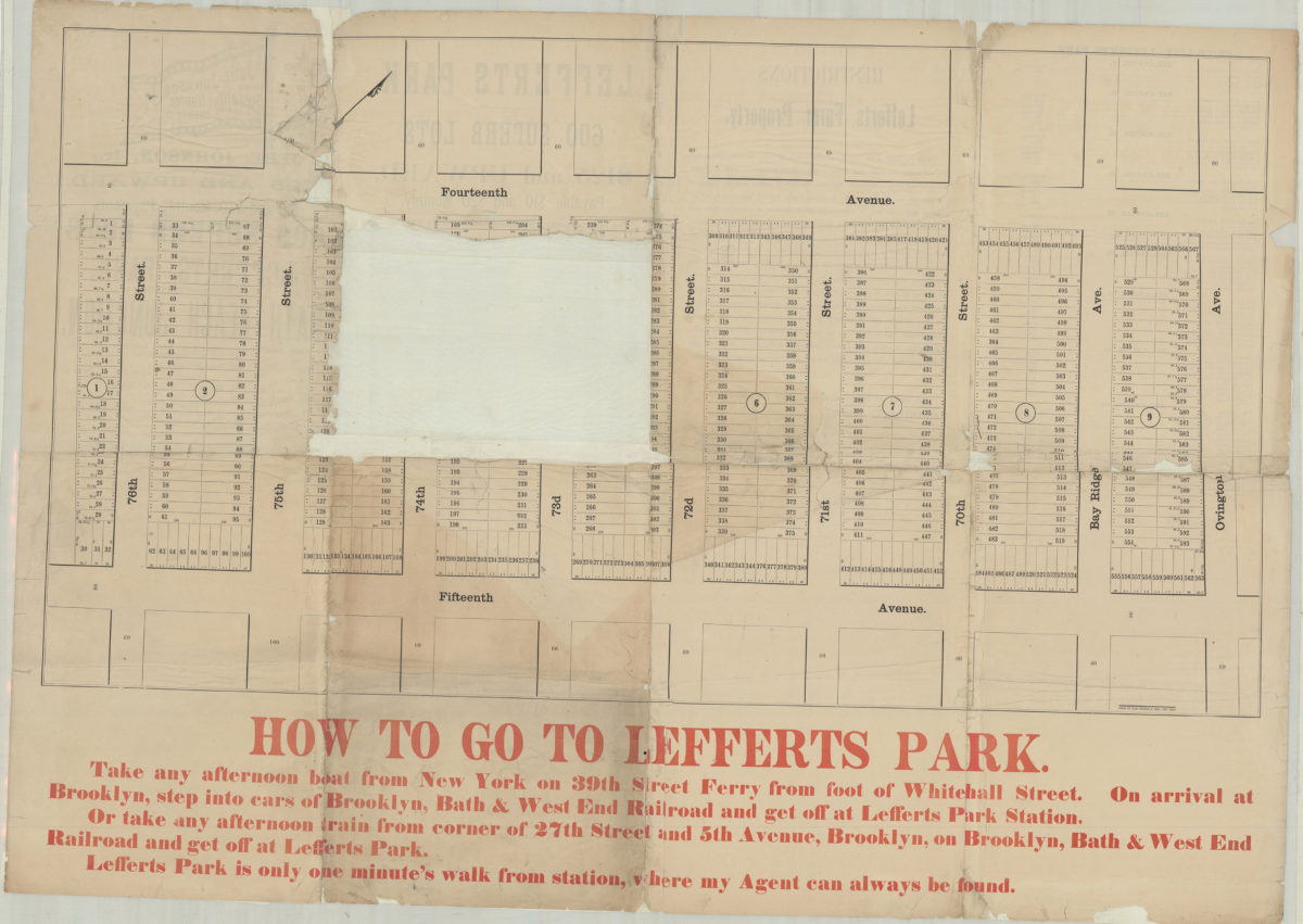
Jere. Johnson, Jr., offers at private sale … 600 superb lots in Lefferts Park, the fourth grand subdivision of Bath Beach Junction, where during the past three years 3,500 lots have been sold and 300 buildings erected
Jere. Johnson, Jr., offers at private sale … 600 superb lots in Lefferts Park, the fourth grand subdivision of Bath Beach Junction, where during the past three years 3,500 lots have been sold and 300 buildings erected
[188?]
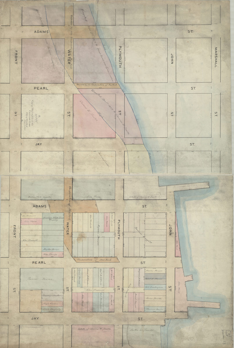
Copy of map on file in the Collector’s Office, City of New York: N. Aug. Northup
Copy of map on file in the Collector’s Office, City of New York: N. Aug. Northup
[188?]
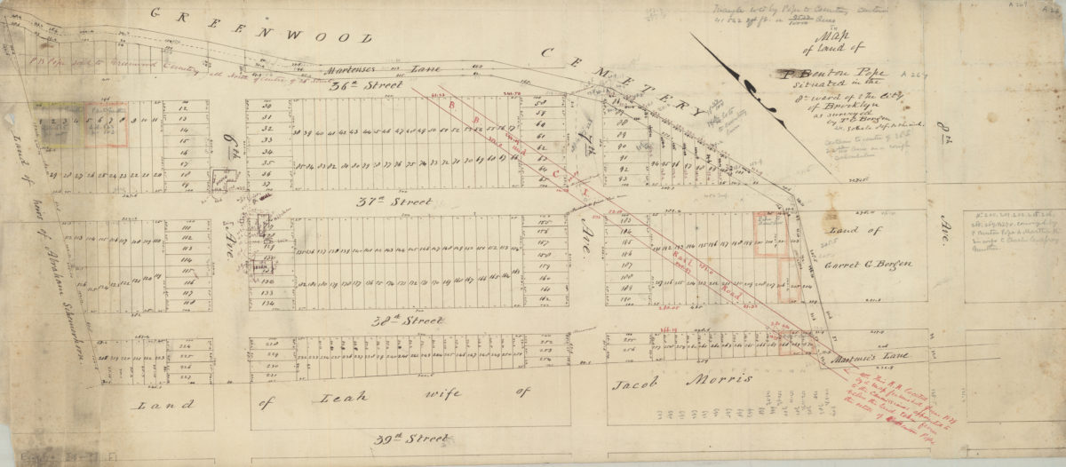
Map of land of P. Benton Pope, situated in the 8th Ward of the city of Brooklyn: as surveyed by T.G. Bergen
Map of land of P. Benton Pope, situated in the 8th Ward of the city of Brooklyn: as surveyed by T.G. Bergen
[188?]
Brooklyn, Flatbush and Coney Island guide map to Brighton Beach, 1881
[ca. 1880]
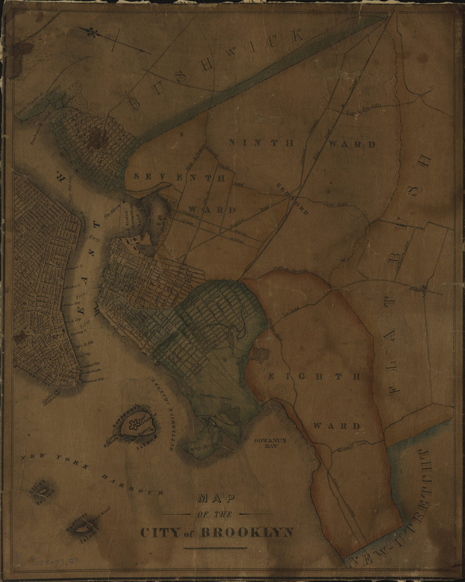
Map of the city of Brooklyn
Map of the city of Brooklyn
[188?]
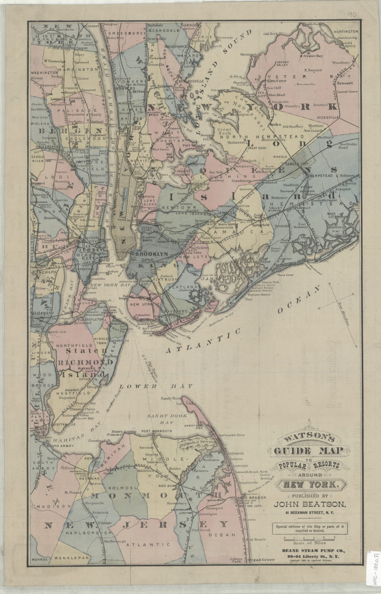
Watson’s guide map to popular resorts around New York
Watson’s guide map to popular resorts around New York
[ca. 1880]
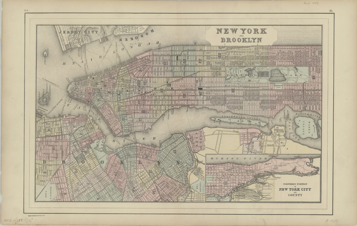
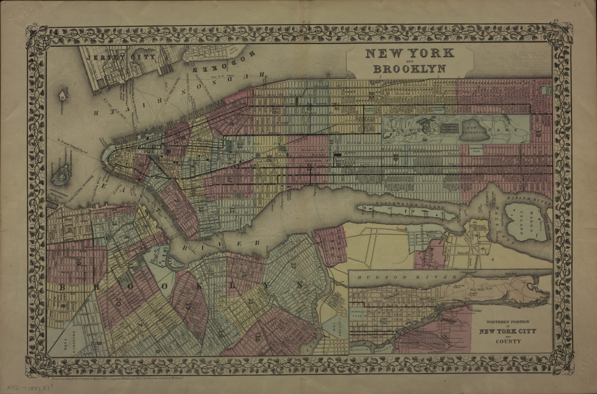
New York and Brooklyn
New York and Brooklyn
[188?]
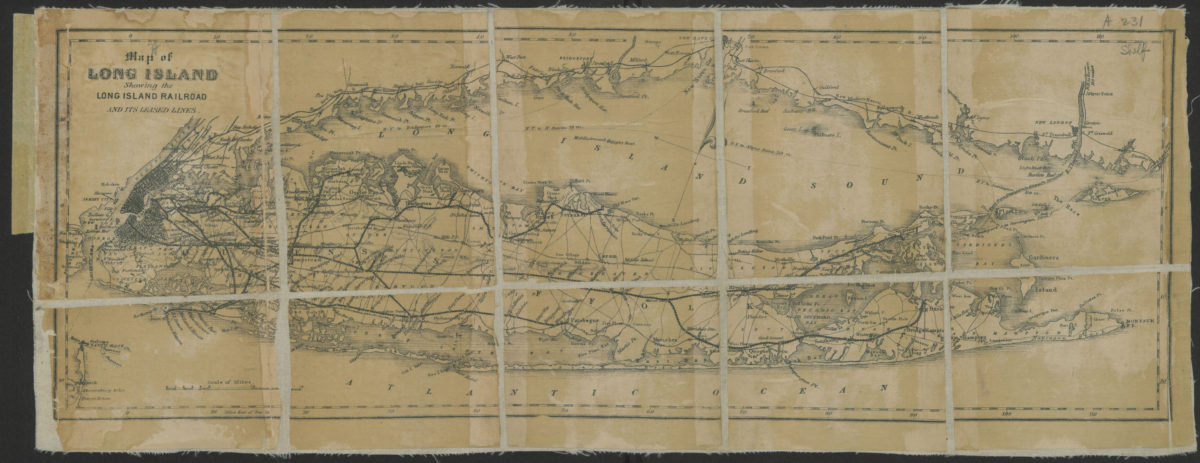
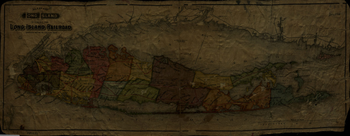
Map of Long Island showing the Long Island Railroad and its leased lines
Map of Long Island showing the Long Island Railroad and its leased lines
[188?]
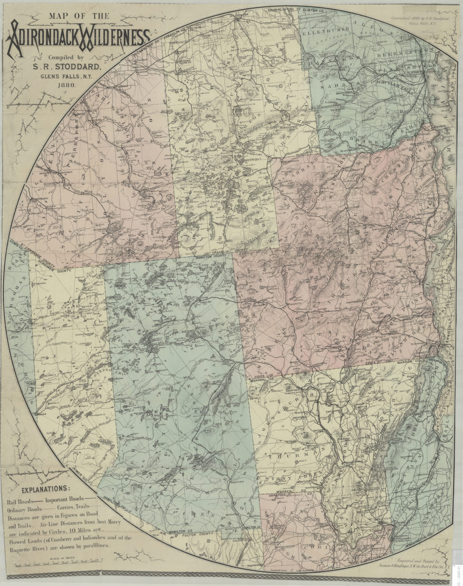
Map of the Adirondack wilderness: compiled by S.R. Stoddard
Map of the Adirondack wilderness: compiled by S.R. Stoddard
1880
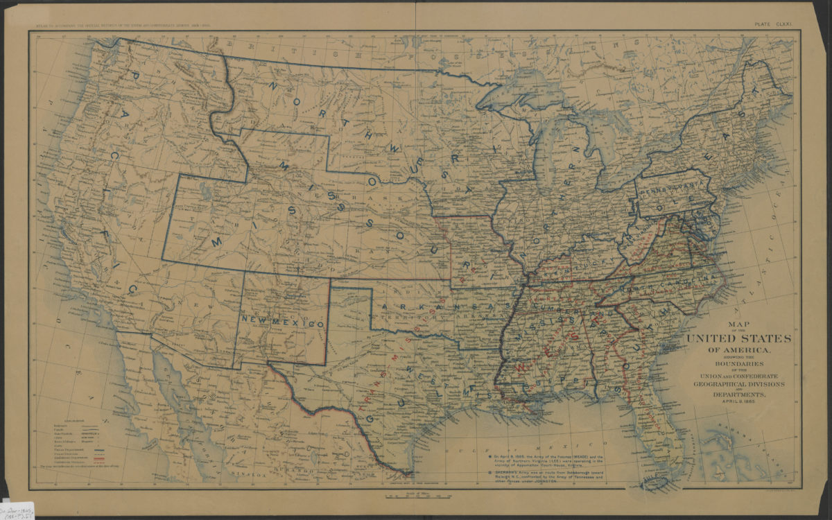
Map of the United States of America, showing the boundaries of the Union and Confederate geographical divisions and departments, April 9, 1865
Map of the United States of America, showing the boundaries of the Union and Confederate geographical divisions and departments, April 9, 1865
[188?]
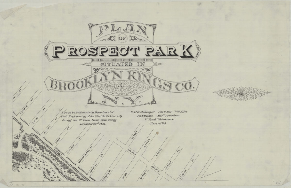
Plan of Prospect Park, situated in Brooklyn, Kings Co., N.Y.: drawn by students in the Department of Civil Engineering of the New York University during the 1st term junior year, ending December 23rd 1881
Plan of Prospect Park, situated in Brooklyn, Kings Co., N.Y.: drawn by students in the Department of Civil Engineering of the New York University during the 1st term junior year, ending December 23rd 1881
[1881]
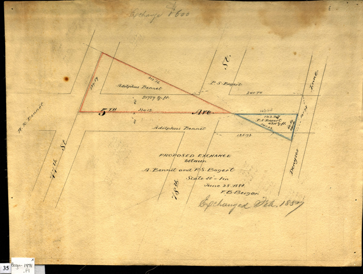
Proposed exchange between A. Bennet and P.S. Bogert, June 28, 1881: V. B. Bergen
Proposed exchange between A. Bennet and P.S. Bogert, June 28, 1881: V. B. Bergen
June 28, 1881
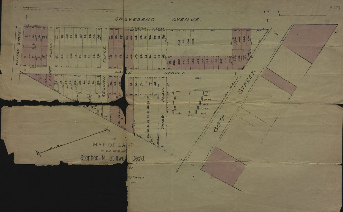
Map of land of the heirs of Stephen N. Stillwell, dec’d
Map of land of the heirs of Stephen N. Stillwell, dec’d
1881
New York and Brooklyn
New York and Brooklyn
[ca. 1881]
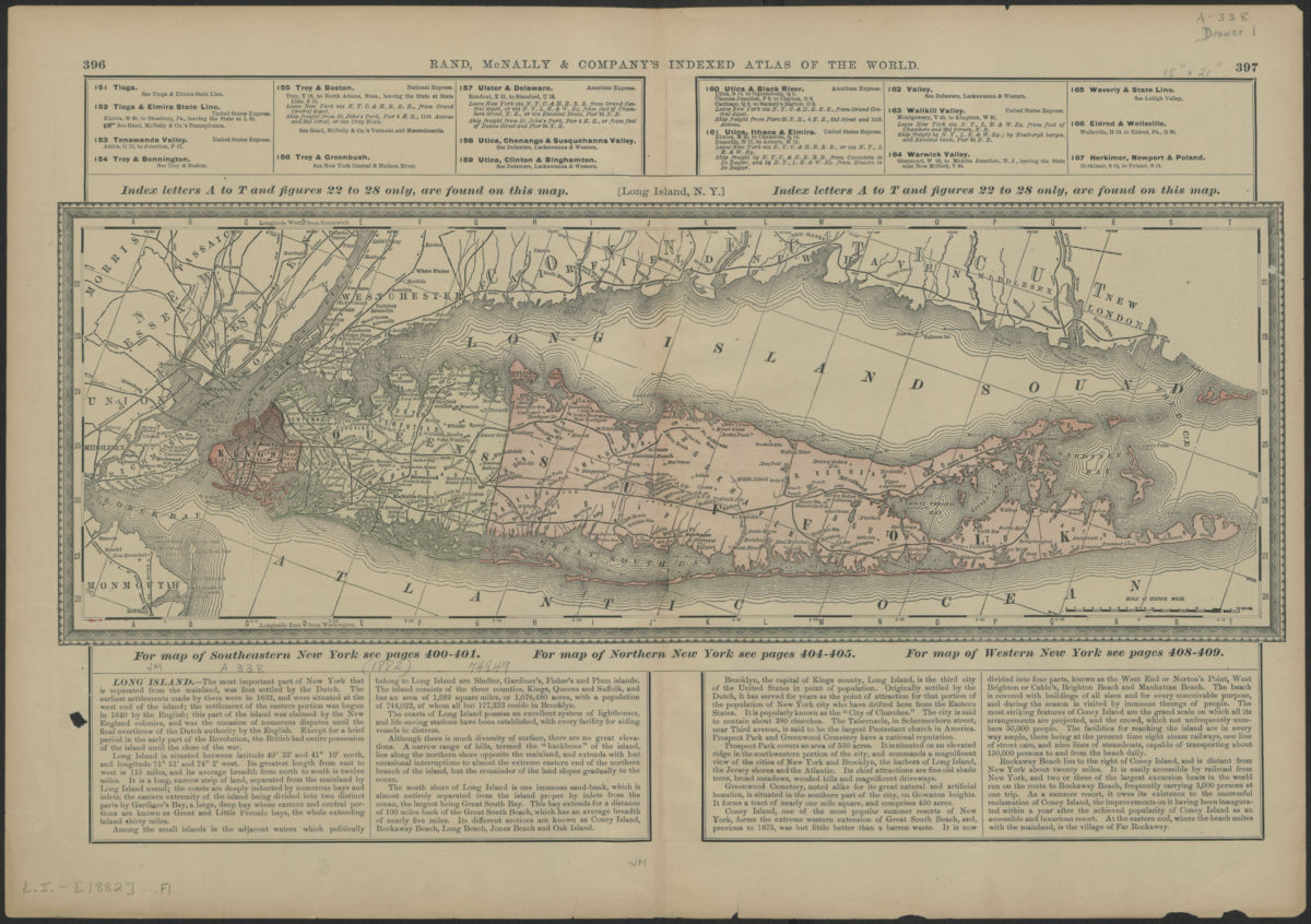
Long Island, N.Y.
Long Island, N.Y.
[1882]
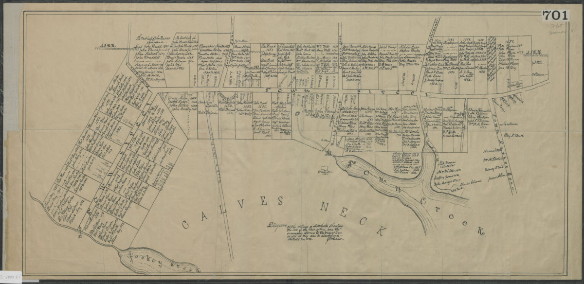
Diagram of the village of Southold showing the lots of the first settlers, and the succeeding owners, to the present times, as far as they can be ascertained: J.M. Case
Diagram of the village of Southold showing the lots of the first settlers, and the succeeding owners, to the present times, as far as they can be ascertained: J.M. Case
March 1882
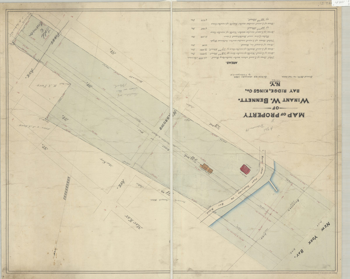
Map of property of Winant W. Bennett, Bay Ridge, Kings Co., N.Y.: surveyed by V.B. Bergen, C.E.
Map of property of Winant W. Bennett, Bay Ridge, Kings Co., N.Y.: surveyed by V.B. Bergen, C.E.
January 1882
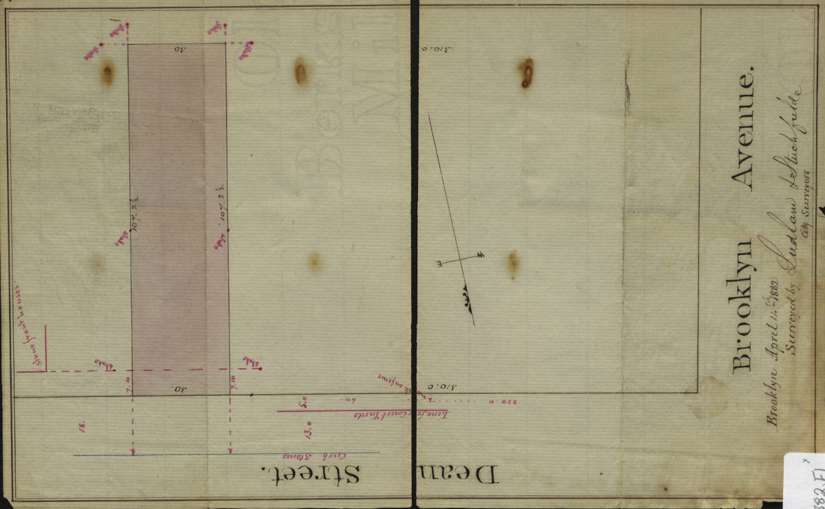
[Map of Dean St. and Brookyln Ave.]: surveyed by Ludlam & Stuchfielde [sic], city surveyors
[Map of Dean St. and Brookyln Ave.]: surveyed by Ludlam & Stuchfielde [sic], city surveyors
April 14, 1882
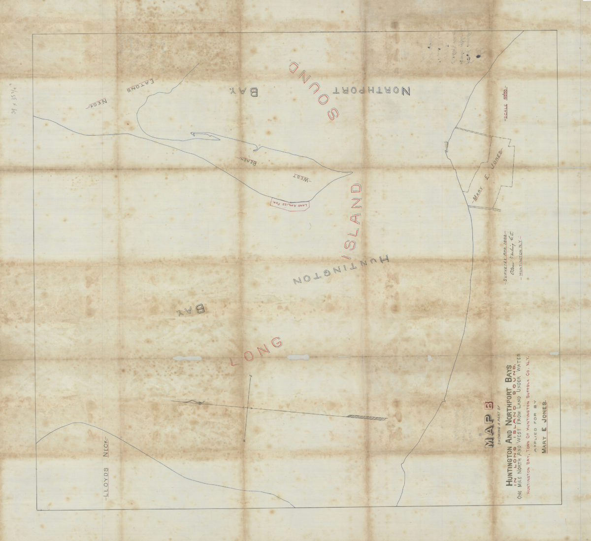
Map B showing a part of Huntington and Northport Bays in Long Island Sound, one mile north and west from land under water, Huntington Bay, town of Huntington, Suffolk Co., N.Y., applied for by Mary E. Jones: Oscar Darling, C.E.
Map B showing a part of Huntington and Northport Bays in Long Island Sound, one mile north and west from land under water, Huntington Bay, town of Huntington, Suffolk Co., N.Y., applied for by Mary E. Jones: Oscar Darling, C.E.
April 1882
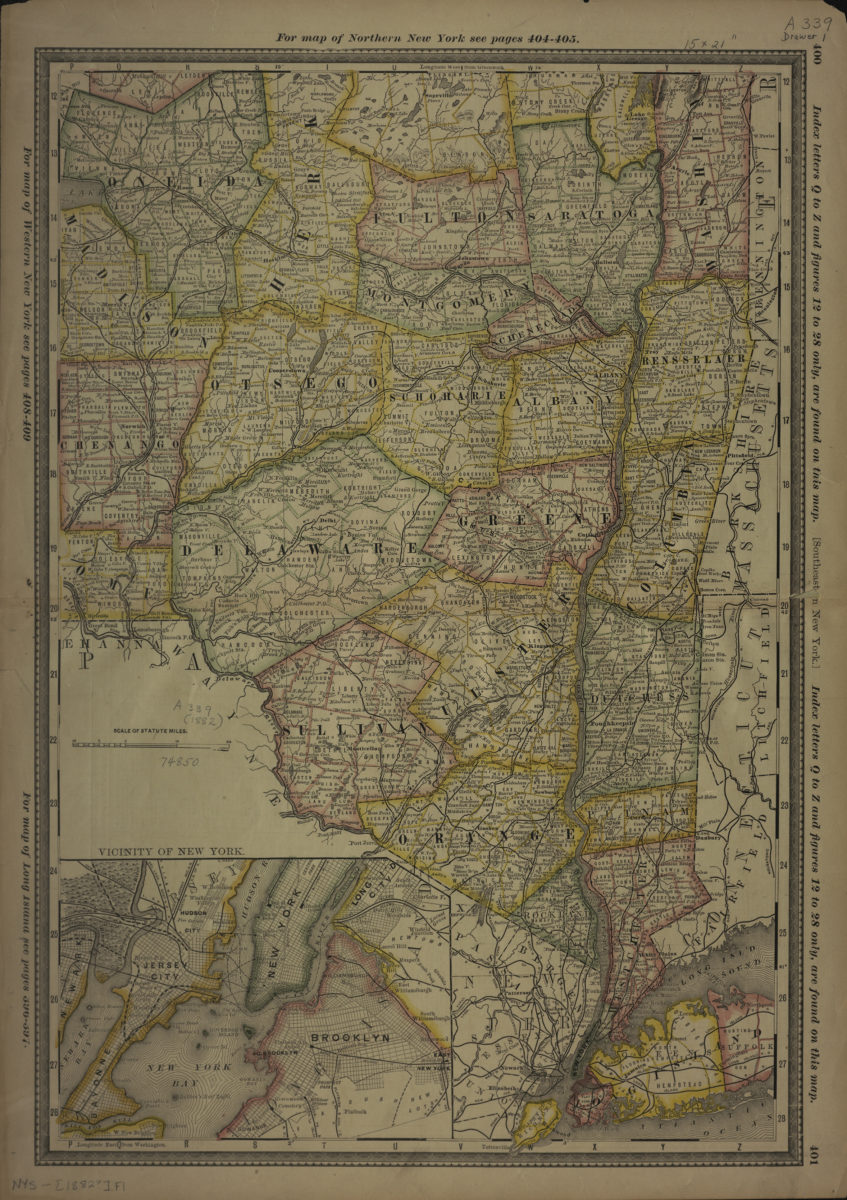
Southeastern New York
Southeastern New York
[1882]
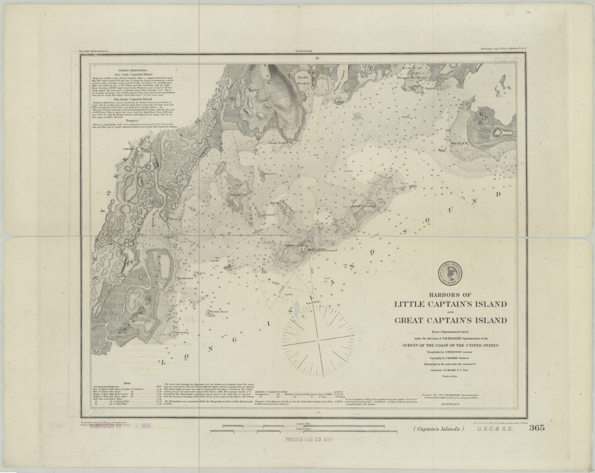
Harbors of Little Captain’s Island and Great Captain’s Island: from a trigonometrical survey under the direction of F.R. Hassler superintendent of the Survey of the Coast of the United States
Harbors of Little Captain’s Island and Great Captain’s Island: from a trigonometrical survey under the direction of F.R. Hassler superintendent of the Survey of the Coast of the United States
[1882]
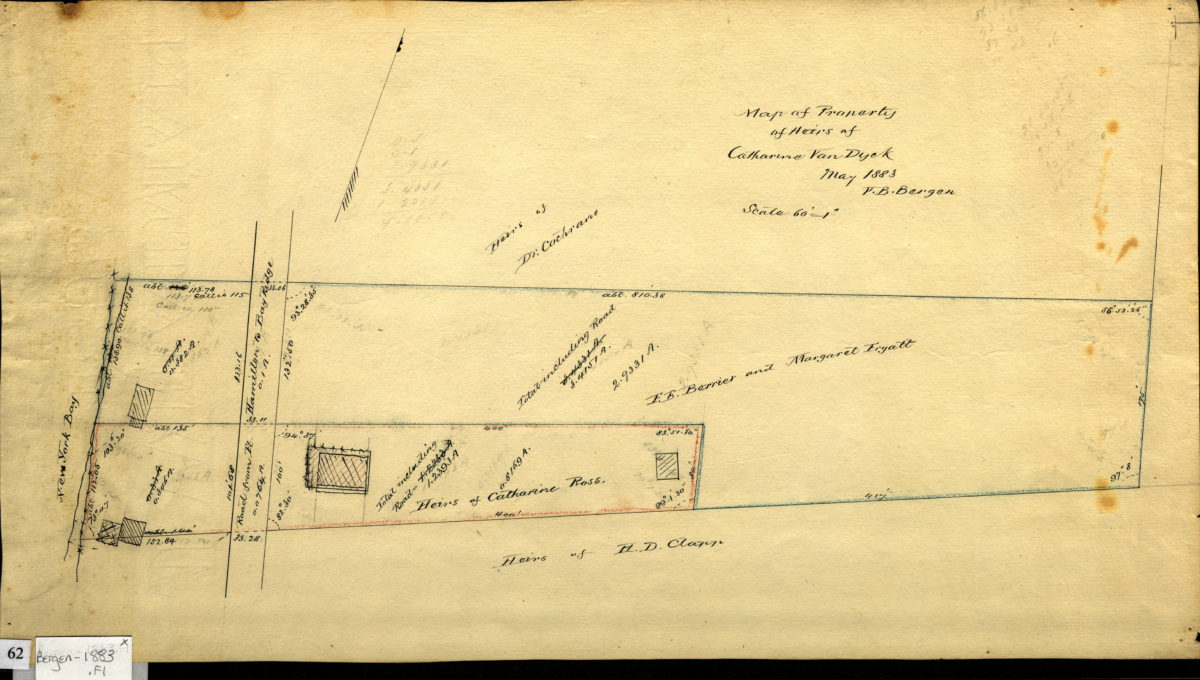
Map of property of heirs of Catherine Van Dyck, May 1883: V. B. Bergen
Map of property of heirs of Catherine Van Dyck, May 1883: V. B. Bergen
1883
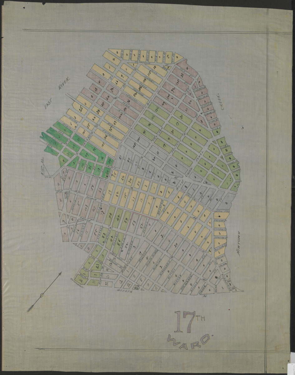
17th Ward
17th Ward
[1883]
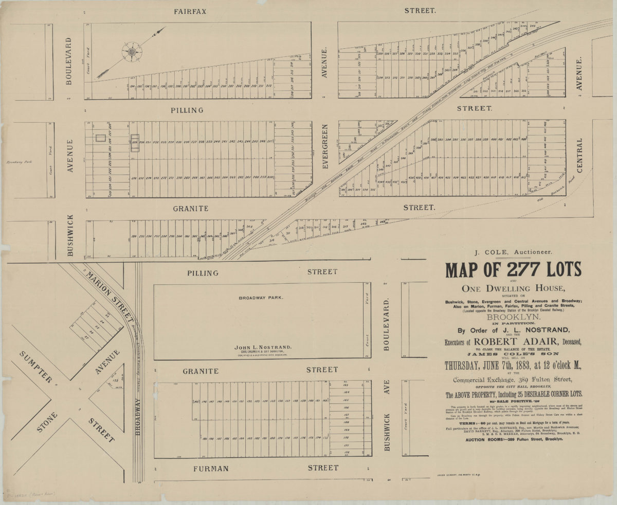
Map of 277 lots and one dwelling house, situated on Bushwick, Stone, Evergreen and Central Avenues and Broadway, also on Marion, Furman, Fairfax, Pilling and Granite Streets (located opposite the Broadway Station of the Brooklyn Elevated Railway)
Map of 277 lots and one dwelling house, situated on Bushwick, Stone, Evergreen and Central Avenues and Broadway, also on Marion, Furman, Fairfax, Pilling and Granite Streets (located opposite the Broadway Station of the Brooklyn Elevated Railway)
[1883]
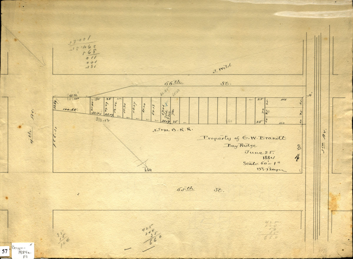
Property of G. W. Brandt, Bay Ridge, June 1884: V. B. Bergen
Property of G. W. Brandt, Bay Ridge, June 1884: V. B. Bergen
1884
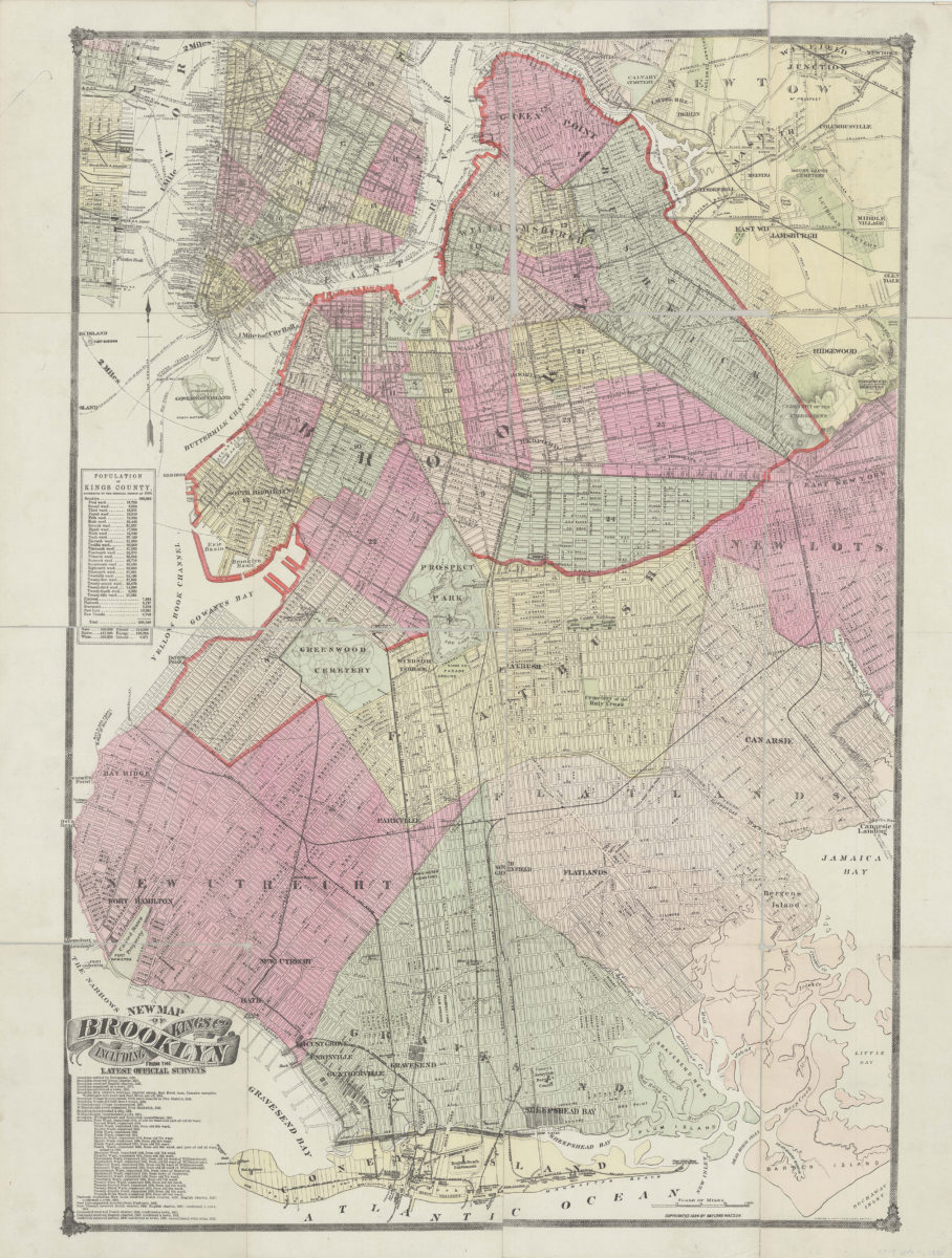
New map of Brooklyn including Kings Co., from the latest official surveys
New map of Brooklyn including Kings Co., from the latest official surveys
[ca. 1884]
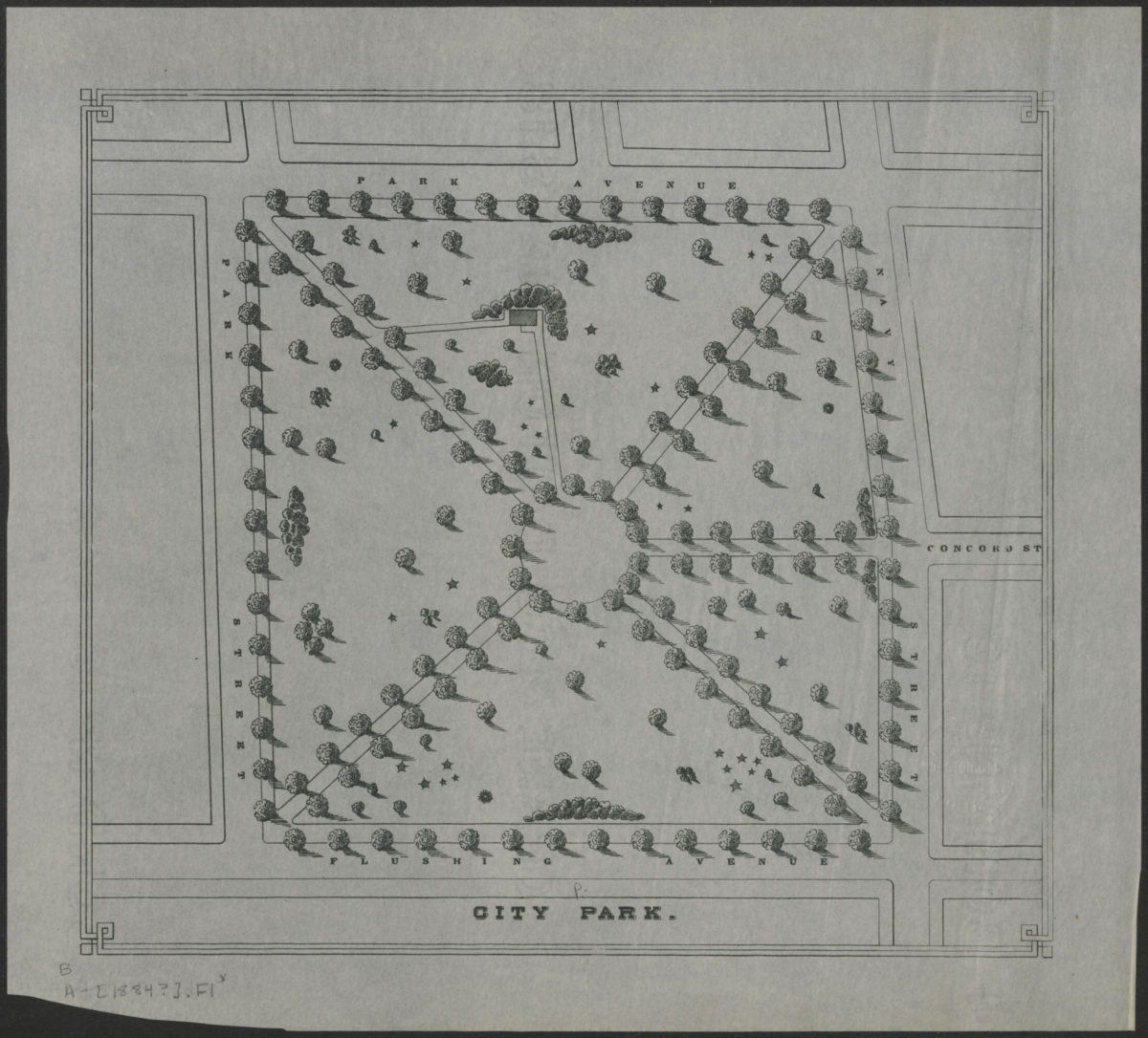
City Park
City Park
[1884]
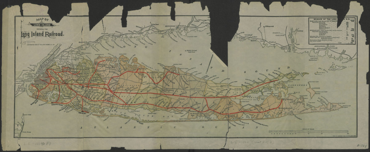
Map of Long Island showing the Long Island Railroad
Map of Long Island showing the Long Island Railroad
[ca. 1884]
Map of Long Island showing the Long Island Railroad
Map of Long Island showing the Long Island Railroad
[ca. 1884]
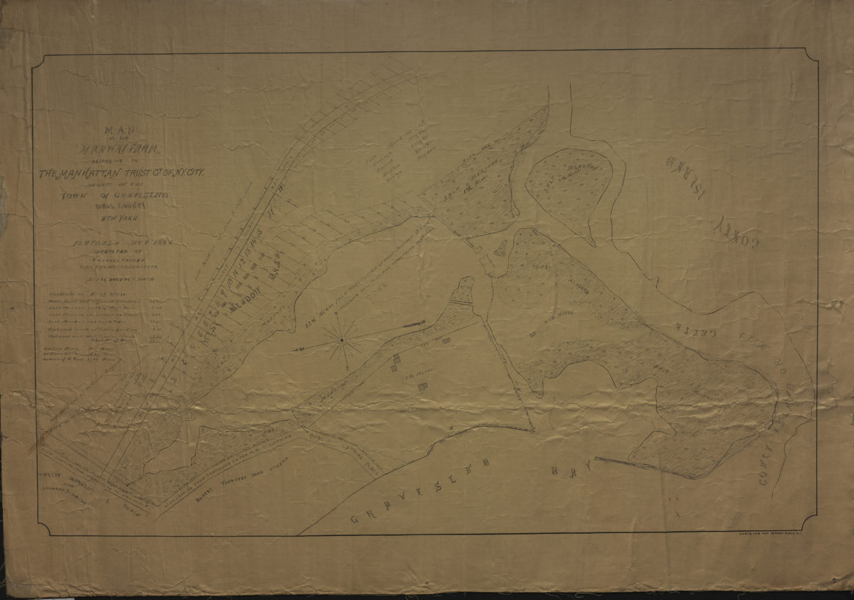
Map of the Marway Farm belonging to the Manhattan Trust Co. of N.Y. City, situate[d] in the town of Gravesend, Kings County, New York: surveyed by Charles Crooke, civil engineer & surveyor
Map of the Marway Farm belonging to the Manhattan Trust Co. of N.Y. City, situate[d] in the town of Gravesend, Kings County, New York: surveyed by Charles Crooke, civil engineer & surveyor
1884
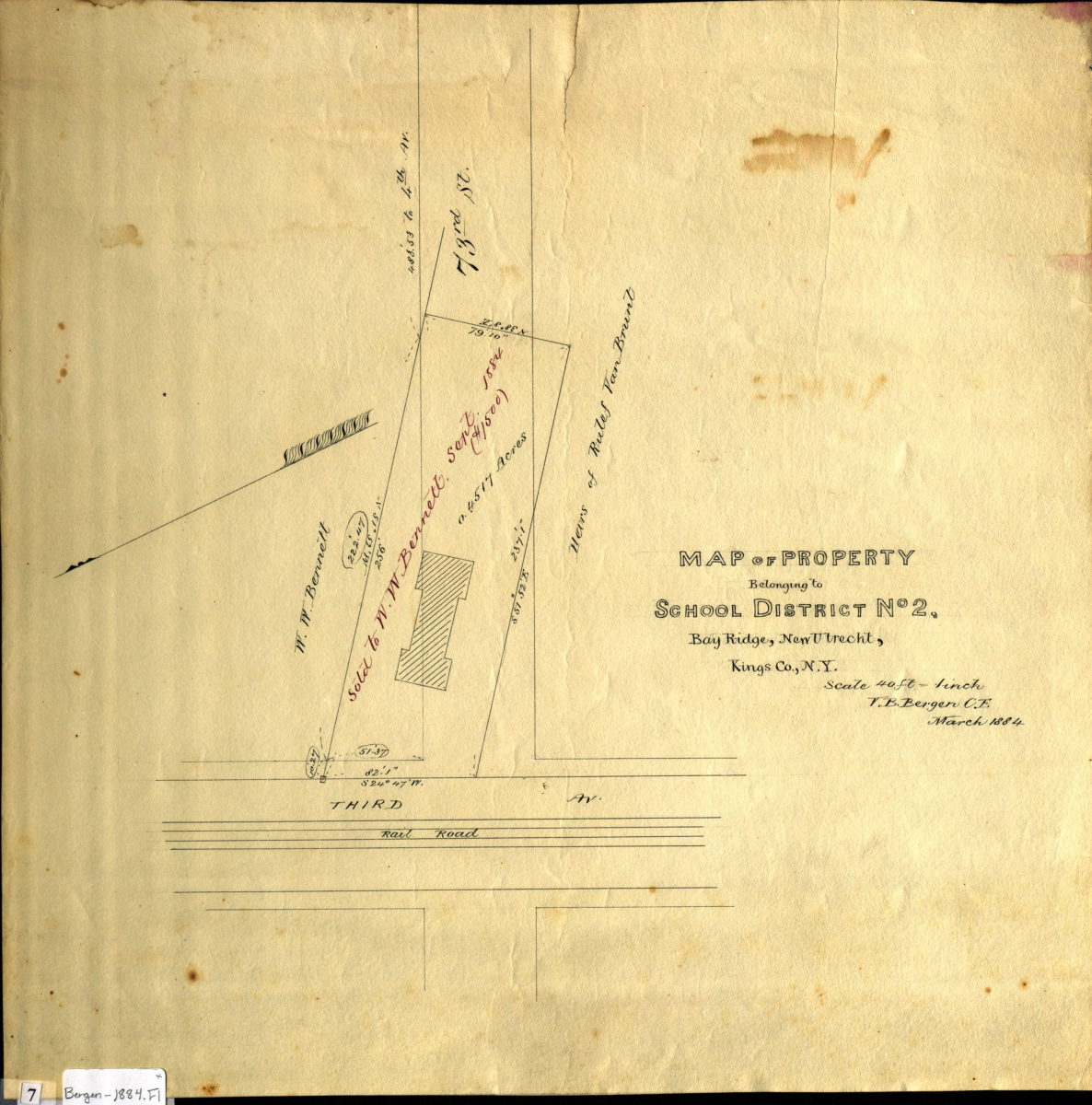
Map of property belonging to School District No. 2, Bay Ridge, New Utrecht, Kings Co., N.Y: V.B. Bergen, C.E.
Map of property belonging to School District No. 2, Bay Ridge, New Utrecht, Kings Co., N.Y: V.B. Bergen, C.E.
March 1884
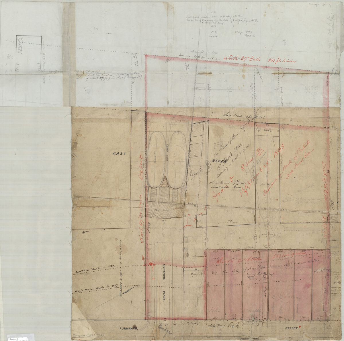
[Map showing grants of land under water near Montague Pl. and Furman St.].
[Map showing grants of land under water near Montague Pl. and Furman St.].
[1885]
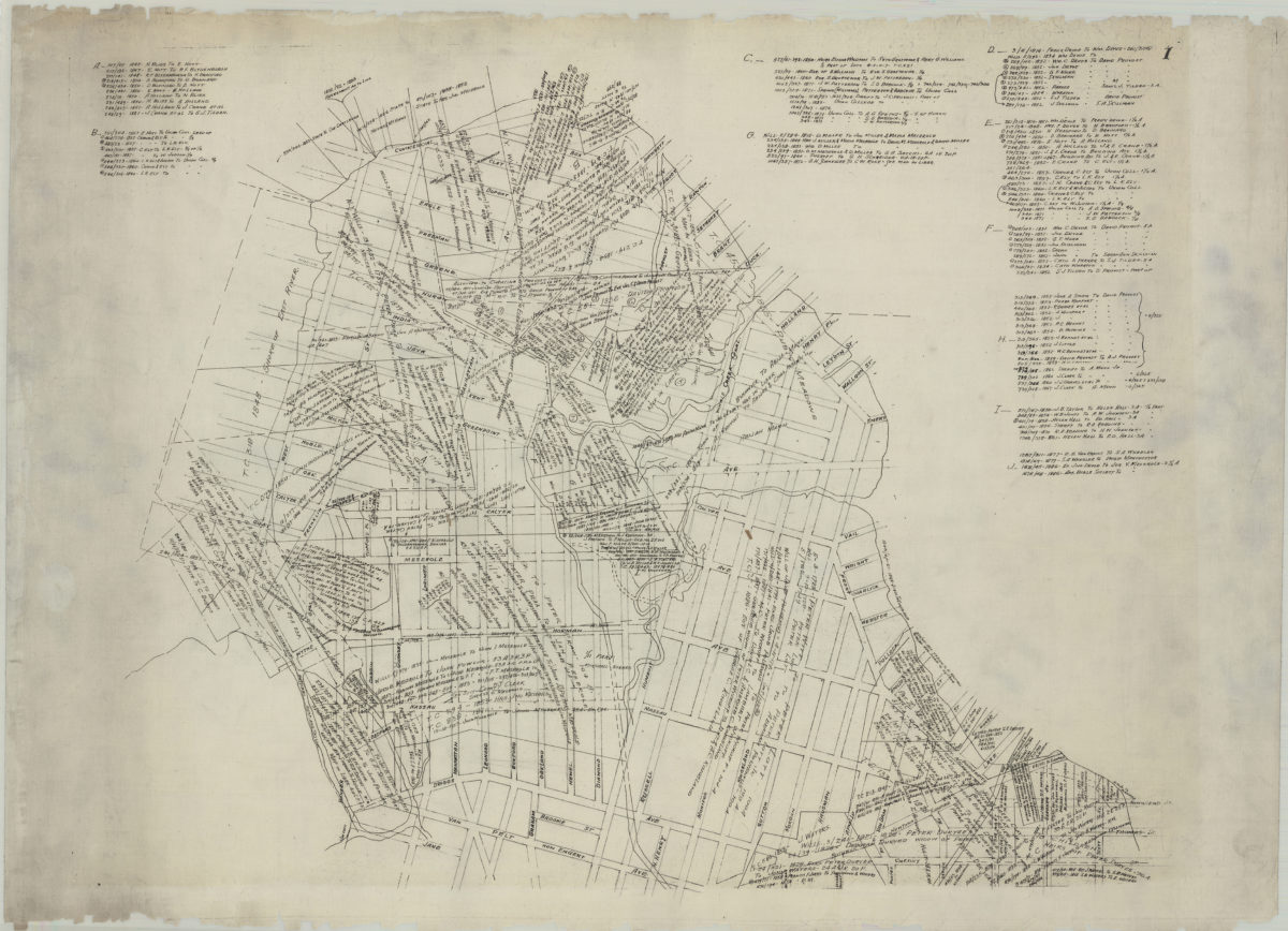
[Map of Greenpoint showing land transfers]
[Map of Greenpoint showing land transfers]
circa 1885
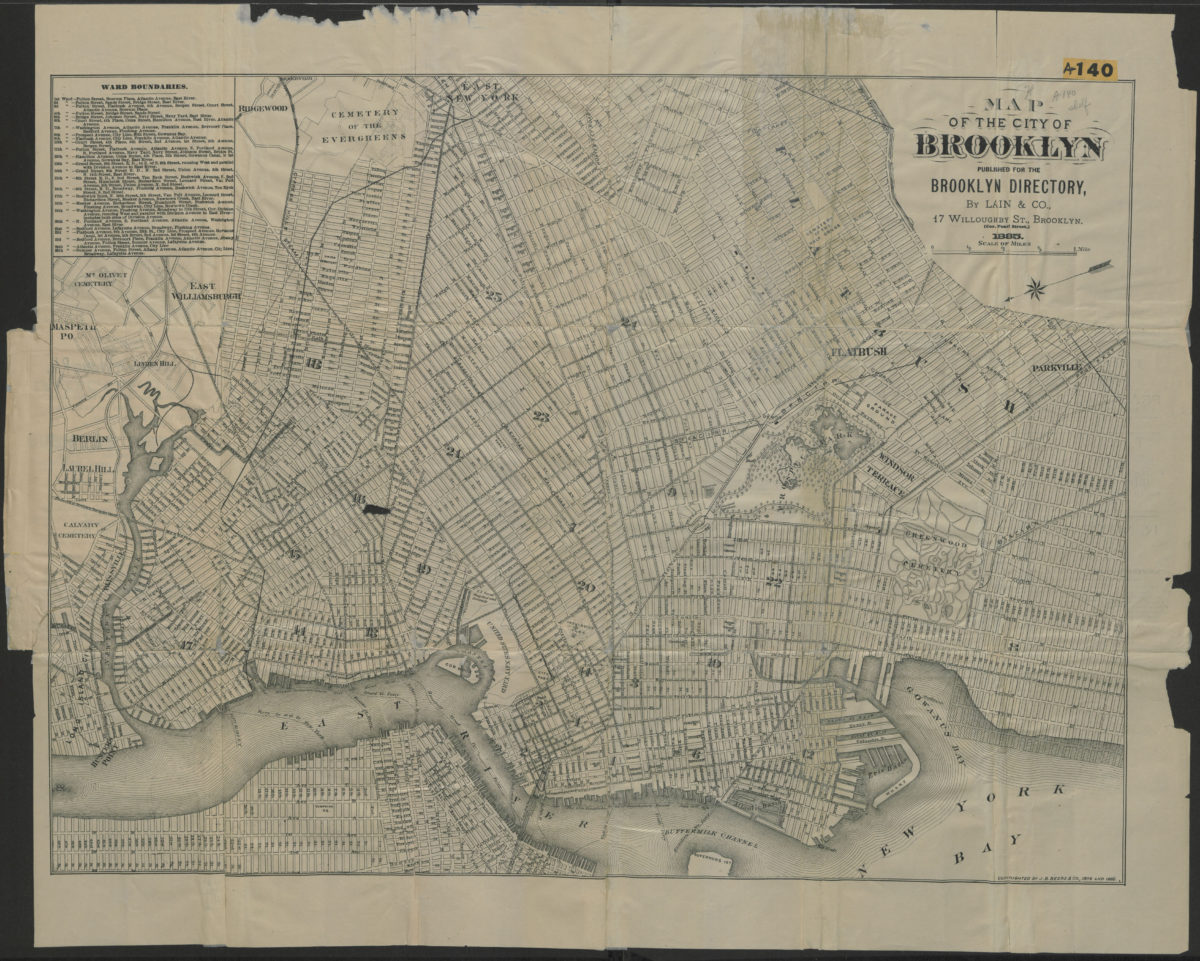
Map of the city of Brooklyn
Map of the city of Brooklyn
1885
[Survey map of 5th Avenue from 92nd Street to 86th Street in Bay Ridge]
[Survey map of 5th Avenue from 92nd Street to 86th Street in Bay Ridge]
[1885]
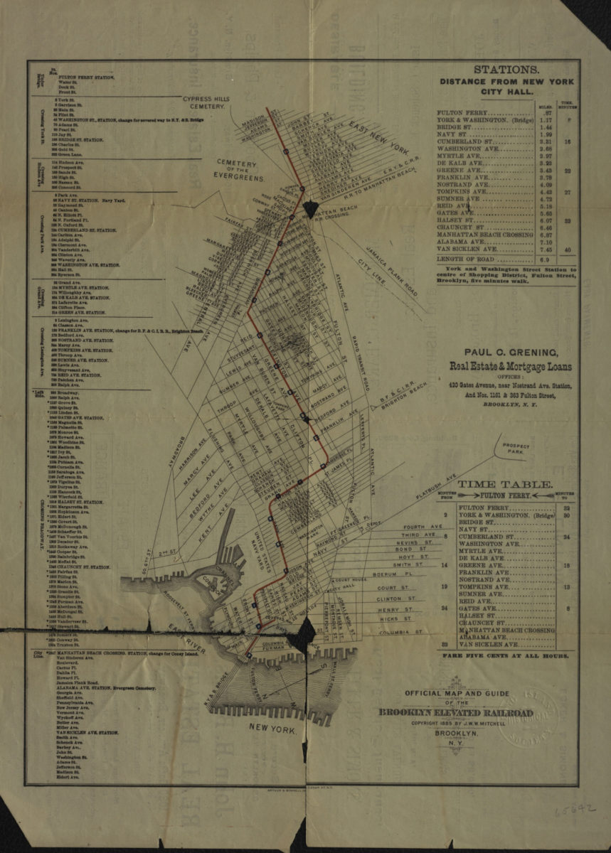
Official map and guide of the Brooklyn Elevated Railroad
Official map and guide of the Brooklyn Elevated Railroad
[ca. 1885]
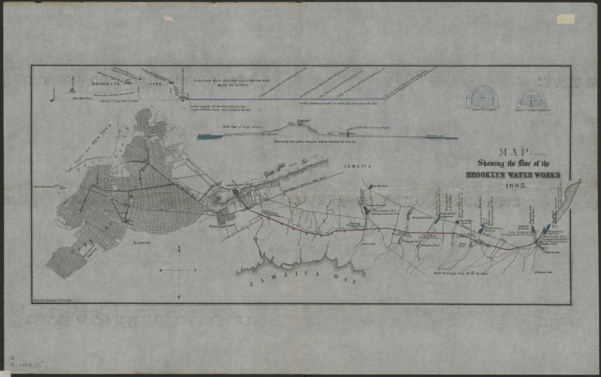
Map showing the line of the Brooklyn Water Works: drawn by Bernhard Essroger
Map showing the line of the Brooklyn Water Works: drawn by Bernhard Essroger
1885
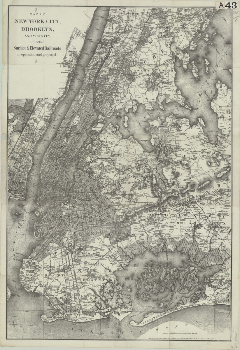
Map of New York City, Brooklyn, and vicinity: showing surface & elevated railroads in operation and proposed
Map of New York City, Brooklyn, and vicinity: showing surface & elevated railroads in operation and proposed
[ca. 1885]
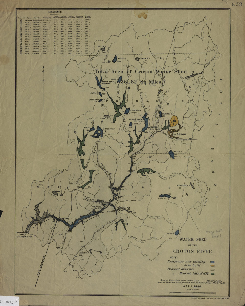
Water shed of the Croton River
Water shed of the Croton River
April 1886
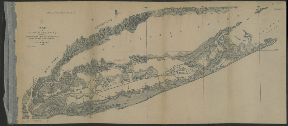
Map of Long Island, showing the southern limit of the ice sheet: adapted from the U.S. Coast Survey Chart: by F.J.H. Merrill
Map of Long Island, showing the southern limit of the ice sheet: adapted from the U.S. Coast Survey Chart: by F.J.H. Merrill
[1886]
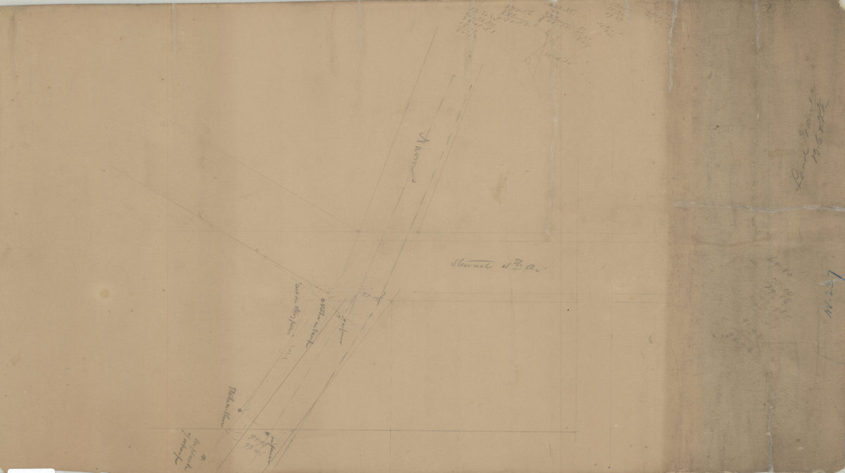
[Survey of Brooklyn City Rail Road Company land grant at the intersection of Narrows Shore Road and Stewart Avenue where it coincides with 4th Avenue]
[Survey of Brooklyn City Rail Road Company land grant at the intersection of Narrows Shore Road and Stewart Avenue where it coincides with 4th Avenue]
[1886]
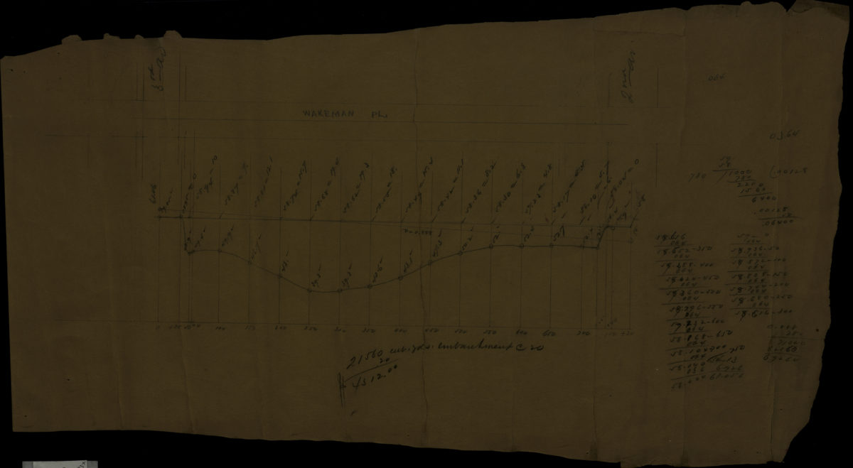
[Profile map of the grade of Wakeman Place between 2nd Avenue and 3rd Avenue]
[Profile map of the grade of Wakeman Place between 2nd Avenue and 3rd Avenue]
[1886]
Map of Brooklyn
Map of Brooklyn
[1886]
Map of New York and vicinity
Map of New York and vicinity
[1886-1894]
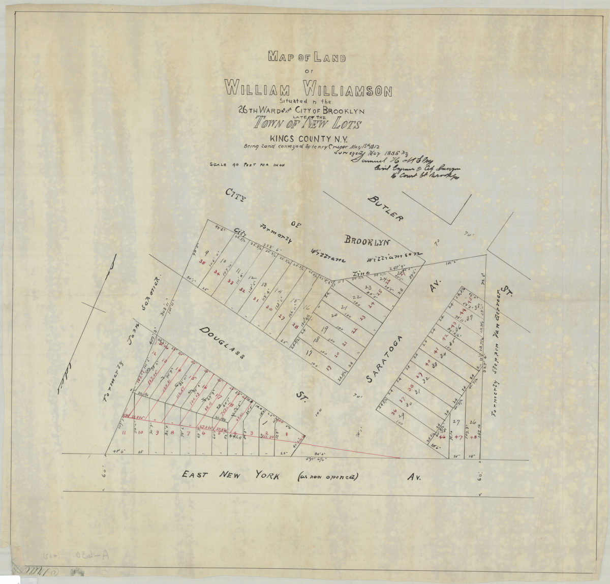
Map of land of William Williamson, situated in the 26th Ward of the city of Brooklyn, late of the town of New Lots, Kings County, N.Y., being land conveyed by Henry Cruger, May 15th, 1812: surveyed … by Samuel H. McElroy, civil engineer
Map of land of William Williamson, situated in the 26th Ward of the city of Brooklyn, late of the town of New Lots, Kings County, N.Y., being land conveyed by Henry Cruger, May 15th, 1812: surveyed … by Samuel H. McElroy, civil engineer
May 1886
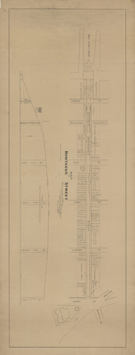
Map of Montague Street: [by] Samuel H. McElroy, civil engineer & city surveyor
Map of Montague Street: [by] Samuel H. McElroy, civil engineer & city surveyor
February 27, 1886
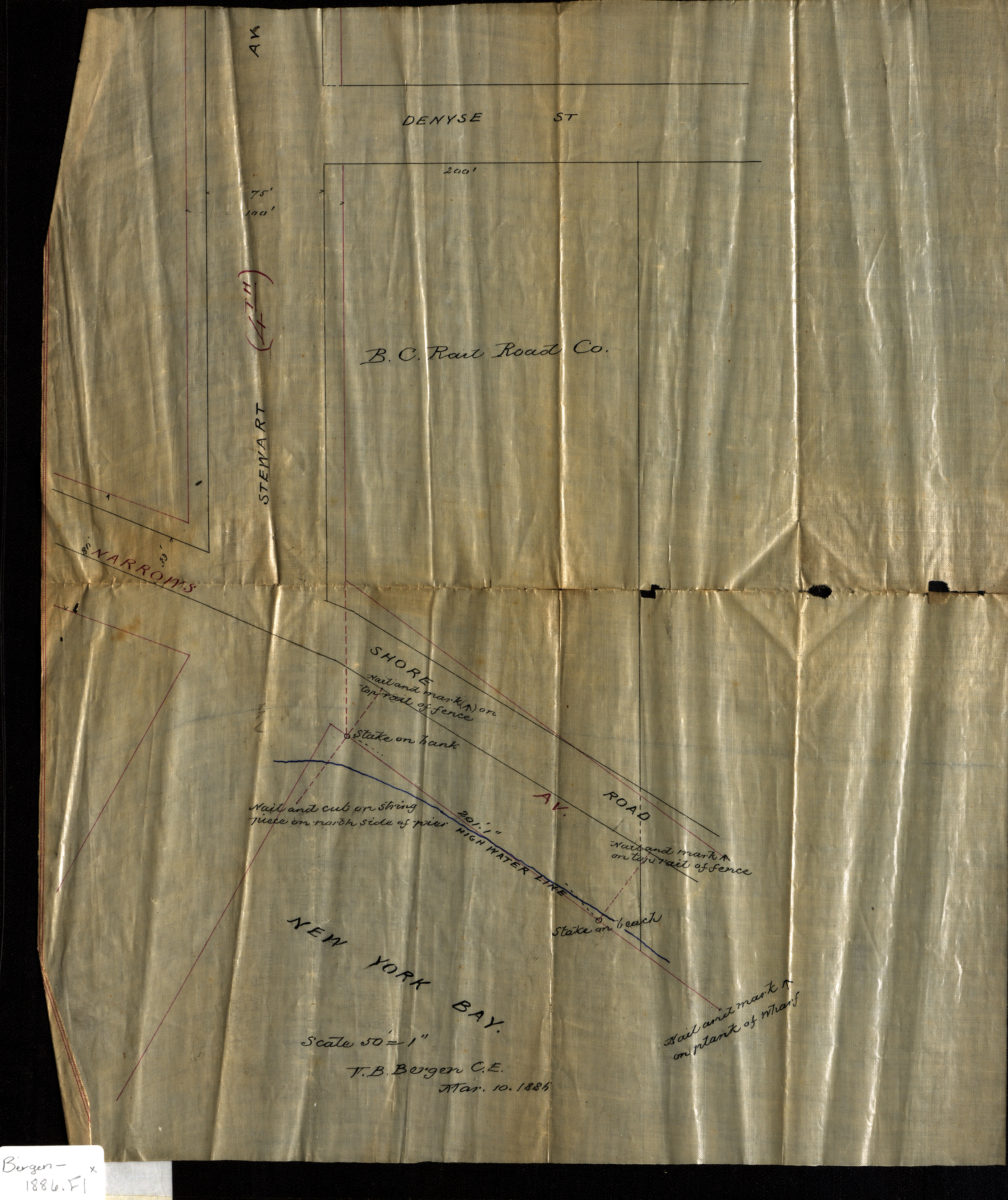
[Map of Stewart Ave. at Narrows Ave. and Shore Rd.]: V.B. Bergen, C.E.
[Map of Stewart Ave. at Narrows Ave. and Shore Rd.]: V.B. Bergen, C.E.
March 10, 1886
Map of the city of Brooklyn, New York: showing house numbers, churches & public schools, horse-car routes, steam & elevated railroads, police & fire stations, & exit from sewers, and a complete street directory, showing width & location of streets &c
Map of the city of Brooklyn, New York: showing house numbers, churches & public schools, horse-car routes, steam & elevated railroads, police & fire stations, & exit from sewers, and a complete street directory, showing width & location of streets &c
[1886]
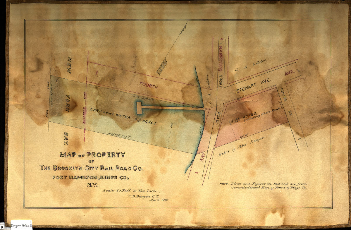
Map of property of the Brooklyn City Rail Road Co., Fort Hamilton, Kings Co., N.Y.: V.B. Bergen, C.E.
Map of property of the Brooklyn City Rail Road Co., Fort Hamilton, Kings Co., N.Y.: V.B. Bergen, C.E.
April 1886
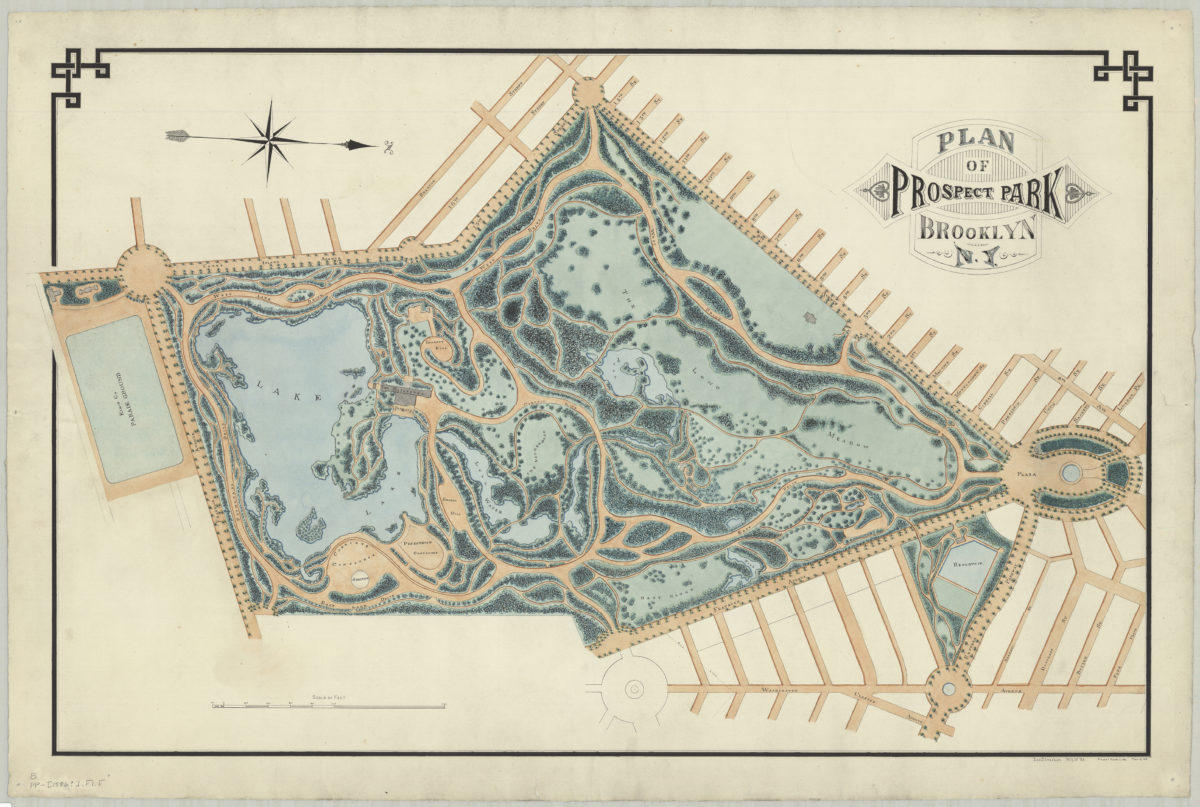
Plan of Prospect Park, Brooklyn, N.Y.: Jos. Strachan, N.Y.U. ’83
Plan of Prospect Park, Brooklyn, N.Y.: Jos. Strachan, N.Y.U. ’83
[1886]
Previous
1
2
3
4
5
6
7
8
9
10
11
12
13
14
15
16
17
18
19
Next