Center for Brooklyn History
Map Collections
Search
About
Othmer Library & Archives
Submit search query
Browse 1493 records
Location
Abingdon Square (New York, N.Y.)
1
Adirondack Mountains (N.Y.)
2
Adirondack Park (N.Y.)
1
Albany (N.Y.)
3
Albany County (N.Y.)
1
Albion (Oswego County : Town)
1
Amagansett (N.Y.)
1
Amityville (N.Y.)
1
Annastown (N.Y.)
1
Astoria (New York, N.Y.)
4
Atlantic Basin (New York, N.Y.)
3
Atlantic Coast (North America)
6
Atlantic Ocean.
1
Atlantic States
2
Auburn (N.Y.)
1
Babylon (N.Y. : Town)
2
Babylon (N.Y.)
1
Bath Beach (New York, N.Y.)
8
Battery Park (New York, N.Y.)
3
Bay Ridge (New York, N.Y.)
108
Bay Ridge Park (New York, N.Y.)
1
Bedford (N.Y. : Town)
1
Bedford-Stuyvesant (New York, N.Y.)
67
Bellerose (New York, N.Y.)
1
Belt Parkway (New York, N.Y.)
1
Bensonhurst (New York, N.Y.)
17
Bergen Beach (New York, N.Y.)
3
Bergen County (N.J.)
6
Block Island (R.I. : Island)
2
Blythebourne (New York, N.Y.)
1
Boerum Hill (New York, N.Y.)
6
Borough Park (New York, N.Y.)
23
Boylston (N.Y.)
1
Brandon (N.Y.)
1
Bridgehampton (N.Y.)
1
Brighton Beach (New York, N.Y.)
4
Brightwaters (N.Y.)
1
Bronx (New York, N.Y.)
10
Brookhaven (N.Y. : Town)
3
Brookhaven (N.Y.)
2
Brooklyn (New York, N.Y.)
891
Brooklyn Botanic Garden
2
Brooklyn Heights (New York, N.Y.)
76
Brooklyn-Battery Bridge (New York, N.Y.)
1
Brooklyn-Queens Expressway (New York, N.Y.)
3
Brownsville (New York, N.Y.)
10
Buffalo (N.Y.)
3
Bushwick (New York, N.Y.)
20
Bushwick Park (New York, N.Y.)
1
Buttermilk Channel (New York, N.Y.)
1
Canarsie (New York, N.Y.)
18
Caribbean Area
2
Carroll Gardens (New York, N.Y.)
21
Carroll Park (New York, N.Y.)
1
Cemetery of the Evergreens (New York, N.Y.)
1
Central Park (New York, N.Y.)
3
Champlain Canal (N.Y.)
1
Champlain, Lake
1
City Hall Park (New York, N.Y.)
1
Clermont (N.Y. : Town)
1
Clinton County (N.Y.)
1
Clinton Hill (New York, N.Y.)
10
Cobble Hill (New York, N.Y.)
7
Cold Spring Harbor (N.Y.)
1
College Point (New York, N.Y.)
2
Columbia County (N.Y.)
1
Columbia Street Waterfront District (New York, N.Y.)
3
Columbus Park (New York, N.Y.)
1
Commodore Barry Park (New York, N.Y.)
1
Coney Island (New York, N.Y.)
22
Connecticut
7
Connecticut River
1
Constable (N.Y.)
1
Corona (New York, N.Y.)
2
Cortelyou Farm (New York, N.Y.)
1
Cowenhoven Homestead (Brooklyn, New York, N.Y.)
1
Croton Aqueduct (N.Y.)
3
Croton River Watershed (N.Y.)
2
Crown Heights (New York, N.Y.)
25
Cypress Hills (New York, N.Y.)
8
David Johnson Farm (New York, N.Y.)
1
Delaware County (N.Y.)
1
Delaware River Valley (N.Y.-Del. and N.J.)
1
Denmark (N.Y.)
1
Dickinson (N.Y.)
2
Ditmas Park (New York, N.Y.)
1
Douglaston (New York, N.Y.)
1
Downtown Brooklyn (New York, N.Y.)
29
Duane Street Park (New York, N.Y.)
1
DUMBO Historic District (New York, N.Y.)
7
Dunkirk (N.Y.)
1
Dutchess County (N.Y.)
2
Dyker Heights (New York, N.Y.)
23
East (U.S.)
1
East Elmhurst (New York, N.Y.)
2
East Flatbush (New York, N.Y.)
23
East Hampton (N.Y.)
1
East Harlem (New York, N.Y.)
1
East Midwood (New York, N.Y.)
1
East New York (New York, N.Y.)
16
East Patchogue (N.Y.)
1
East River (N.Y.)
3
Elmhurst (New York, N.Y.)
1
Elmont (N.Y.)
1
Erasmus (New York, N.Y.)
1
Erie Basin (New York, N.Y.)
2
Erie Canal (N.Y.)
3
Erie County (N.Y.)
1
Essex County (N.J.)
4
Fairfield County (Conn.)
5
Far Rockaway (New York, N.Y.)
2
Farragut (New York, N.Y.)
1
ferries
1
Flatbush (New York, N.Y.)
35
Flatiron District (New York, N.Y.)
1
Flatlands (New York, N.Y.)
19
Flushing (New York, N.Y.)
13
Flushing Meadows-Corona Park (New York, N.Y.)
1
Forest Hills Gardens (New York, N.Y.)
1
Fort Brooklyn (New York, N.Y.)
1
Fort Covington (N.Y.)
1
Fort Greene (New York, N.Y.)
22
Fort Hamilton (New York, N.Y.)
31
Fort Montgomery State Historic Site (Highlands, N.Y.)
1
Fort Stanwix (Rome, N.Y.)
1
Fort Totten (N.Y.)
1
Fort Washington (New York, N.Y.)
2
Franklin County (N.Y.)
2
Freeport (N.Y.)
1
Fulton Ferry Historic District (New York, N.Y.)
5
Futurama (New York, N.Y.)
2
Gardiners Bay (N.Y.)
1
Genesee County (N.Y.)
2
Genesee River (Pa. and N.Y.)
1
George, Lake (N.Y. : Lake)
1
Germantown (N.Y. : Town)
1
Gerritsen Beach (New York, N.Y.)
2
Glen Cove (N.Y.)
1
Gowanus (New York, N.Y.)
12
Gowanus Bay (New York, N.Y.)
1
Gowanus Canal (New York, N.Y.)
5
Gramercy Park (New York, N.Y.)
1
Grand Army Plaza (Brooklyn, New York, N.Y.)
1
Gravesend (New York, N.Y.)
25
Great Neck (N.Y.)
3
Green-Wood Cemetery (New York, N.Y.)
2
Greenboro (N.Y.)
1
Greene County (N.Y.)
3
Greenpoint (New York, N.Y.)
38
Greenport (N.Y.)
1
Greenwich Village (New York, N.Y.)
1
Greenwood (New York, N.Y.)
1
Greenwood Lake Region (N.J. and N.Y.)
1
Hanover (N.H.)
1
Hanover Region (N.H.)
1
Harlem (New York, N.Y.)
1
Harrisburgh (N.Y.)
1
Hell Gate (New York, N.Y.)
2
Hempstead (N.Y.)
13
Herbert Von King Park (New York, N.Y.)
1
Hicksville (N.Y.)
1
Hinsdale (New York, N.Y.)
1
Hoboken (N.J.)
1
Holland Tunnel (Jersey City, N.J., and New York, N.Y.)
1
Hudson County (N.J.)
3
Hudson Highlands (N.Y.)
1
Hudson River (N.Y. and N.J.)
7
Hunters Point (New York, N.Y.)
2
Huntington (N.Y.)
7
Inwood (New York, N.Y.)
1
Islip (N.Y.)
5
Ithaca, N.Y.
1
Jamaica (New York, N.Y.)
8
Jamaica Bay (N.Y.)
5
Jefferson County (N.Y.)
1
Jersey City (N.J.)
4
Kensington (New York, N.Y.)
11
Kings County (New York, N.Y.)
8
Kings Highway (New York, N.Y.)
1
Kingslandville (New York, N.Y.)
1
Lakeland (N.Y.)
1
Lawrence (Mercer County, N.J. : Township)
1
Lawrence Beach (N.Y.)
1
Lebanon (N.H.)
1
Lebanon Region (N.H.)
1
Lefferts Park (New York, N.Y.)
1
Lewis County (N.Y.)
2
Lindenhurst (N.Y.)
1
Livingston (N.Y. : Town)
1
Livingston County (N.Y.)
1
Lloyd Harbor (N.Y.)
1
Long Island (N.Y.)
197
Long Island City (New York, N.Y.)
8
Long Island Sound (N.Y. and Conn.)
12
Long Island, Battle of, New York, N.Y., 1776
4
Lorraine (N.Y.)
1
Lower Bay (N.Y. and N.J.)
1
Madison Square Park (New York, N.Y.)
1
Maidenhead (N.J.)
1
Maine, Gulf of
1
Malba (New York, N.Y.)
1
Manhattan (New York, N.Y.)
120
Manhattan Beach (New York, N.Y.)
2
Marine Park (New York, N.Y.)
5
Maritime Provinces
1
Martense Farm (New York, N.Y.)
1
Martinsburg (N.Y.)
1
Marway Farm (New York, N.Y.)
1
Maspeth (New York, N.Y.)
2
Mattituck (N.Y.)
1
Middle Atlantic States
2
Middlesex County (N.J.)
4
Midwood (New York, N.Y.)
9
Mill Basin (New York, N.Y.)
3
Miller Place (N.Y.)
1
Mineola (N.Y.)
1
Mohawk River Valley (N.Y.)
3
Monmouth County (N.J.)
3
Monsignor Mcgolrick Park (New York, N.Y.)
1
Montauk (N.Y.)
4
Morningside Heights (New York, N.Y.)
1
Morris County (N.J.)
3
Napeague Bay (N.Y.)
1
Nassau County (N.Y.)
24
New England
8
New France
1
New Jersey
27
New Lots (New York, N.Y.)
1
New Netherland
2
New Utrecht (New York, N.Y.)
9
New York (N.Y.)
164
New York (State)
95
New York Bight (N.J. and N.Y.)
1
New York Harbor (N.Y. and N.J.)
16
New York Metropolitan Area
40
New York Region
5
Newport County (R.I.)
1
Newtown (New York, N.Y.)
1
Newtown (Queens County, N.Y.)
4
North America
7
North Hempstead (N.Y. : Town)
4
Northport Bay (N.Y. : Bay)
1
Nottingham (New York, N.Y.)
2
Noyack (N.Y.)
1
Ocean Beach (N.Y.)
1
Old Bethpage (N.Y.)
1
Oneida County (N.Y.)
2
Orange County (N.Y.)
7
Orient (N.Y.)
1
Orwell (N.Y.)
2
Osceola (N.Y.)
2
Oswego (N.Y.)
1
Oswego County (N.Y.)
4
Oyster Bay (N.Y.)
9
Park Slope (New York, N.Y.)
16
Parkville (New York, N.Y.)
2
Passaic County (N.J.)
5
Patchogue (N.Y.)
2
Pearsalls (N.Y.)
1
Pennsylvania
4
Pierrepont (N.Y.)
1
Pierrepont Homestead (New York, N.Y.)
6
Pike County (Pa.)
1
Port Jefferson (N.Y.)
1
Port Washington (N.Y.)
1
Prospect Heights (New York, N.Y.)
16
Prospect Lefferts Gardens (Brooklyn, New York, N.Y.)
16
Prospect Park (New York, N.Y.)
25
Prospect Park South (New York, N.Y.)
8
Putnam County (N.Y.)
1
Quechee (Vt.)
1
Quechee Region (Vt.)
1
Queens (New York, N.Y.)
83
Quiogue (N.Y.)
1
Raritan Bay (N.J. and N.Y.)
1
Ravenswood (New York, N.Y.)
4
Red Hook (New York, N.Y.)
19
Rensselaer County (N.Y.)
2
Rhode Island
2
Richmond (N.Y.)
1
Richmond Hill (New York, N.Y.)
2
Ridgewood (New York, N.Y.)
2
Riverhead (N.Y.)
3
Rockaway (New York, N.Y.)
1
Rockaway Beach (New York, N.Y.)
1
Rockland County (N.Y.)
5
Rockville Centre (N.Y.)
2
Rodman (N.Y.)
1
Rosevale (N.Y.)
2
Roslyn (N.Y.)
3
Roslyn Harbor (N.Y.)
1
Roslyn Highlands (N.Y.)
1
Rye (N.Y.)
1
Sag Harbor (N.Y.)
2
Saint Albans (New York, N.Y.)
1
Saint Lawrence River
2
Saltaire (N.Y.)
1
Sand Creek (N.Y.)
1
Saratoga County (N.Y.)
1
Saratoga Springs (N.Y.)
1
Sayville (N.Y.)
1
Schoharie County (N.Y.)
1
Schoharie Creek Valley (N.Y.)
1
Sea Cliff (N.Y.)
1
Sea Gate (New York, N.Y.)
7
Secaucus (N.J.)
1
Sewerage
1
Sheepshead Bay (New York, N.Y.)
13
Shelter Island (N.Y.)
2
Sleepy Hollow (N.Y.)
1
Smithtown (N.Y. : Town)
4
Somerset County (N.J.)
3
South Brooklyn Temperance Village (Brooklyn, New York, N.Y.)
1
South Greenfield (New York, N.Y.)
1
Southampton (N.Y.)
5
Southold (N.Y.)
4
Stapleton (New York, N.Y.)
1
Staten Island (N.Y.)
10
Stony Brook (N.Y.)
1
Stuyvesant Heights (New York, N.Y.)
1
Stuyvesant Square (New York, N.Y.)
1
Suffolk (N.Y.)
1
Suffolk County (N.Y.)
43
Sullivan County (N.Y.)
1
Sunnyside (New York, N.Y.)
1
Sunset Park (New York, N.Y.)
53
Susquehanna River Valley
1
Sussex County (N.J.)
3
Syracuse (N.Y.)
1
Tompkins Square (New York, N.Y.)
1
U.S.
1
Ulster County (N.Y.)
4
Union County (N.J.)
1
Union Square (New York, N.Y.)
1
United States
10
Upper Bay (N.Y. and N.J.)
4
Upper East Side (New York, N.Y.)
1
Upper West Side (New York, N.Y.)
2
Van Pelt Manor House (Brooklyn, New York, N.Y.)
1
Vermont
1
Vinegar Hill Historic District (New York, N.Y.)
4
Wallabout Bay (New York, N.Y.)
6
Washington County (N.Y.)
1
Washington Heights (New York, N.Y.)
2
Washington Square (New York, N.Y.)
1
Weeksville (New York, N.Y.)
7
West Turin (N.Y.)
1
Westchester County (N.Y.)
11
Western Hemisphere
1
Westhampton Beach (N.Y.)
1
Westville (Franklin County, N.Y.)
1
White Plains (N.Y.)
1
White River Junction (Vt.)
1
Whitestone (New York, N.Y.)
3
Williamsburg (New York, N.Y.)
36
Windsor Terrace (New York, N.Y.)
10
Woodhaven (New York, N.Y.)
1
Woodside (New York, N.Y.)
3
Woodstock (Vt.)
1
Woodstock Region (Vt.)
1
Wyoming County (N.Y.)
1
Yaphank (N.Y.)
1
Show 342 more
Subject
Academic libraries
1
Advertising
4
Aeronautical charts
1
African Americans
1
Airports
2
Airways
2
Amusement parks
1
Apartment houses
1
Aqueducts
3
Auctions
32
Automobile racing
1
Baseball teams
1
Bays
5
Bicycle stores
12
Bicycle trails
17
Bookstores
1
Botanical gardens
2
Bridges
13
Brooklyn (New York, N.Y.)
1
Buildings
12
Bulkheads
1
Bus lines
20
Bus travel
22
Cables, Submarine
1
Camp sites, facilities, etc
1
Canals
15
Cartography
1
Cemeteries
17
Central business districts
10
Church property
1
City planning
7
Coasts
4
Community development
2
Counties
1
Country clubs
1
Culture and tourism
1
Cycling
12
Decedents' estates
1
docks
2
Drainage
1
Election districts
36
Electric railroads
5
Elevated highways
1
Ethnic neighborhoods
2
Ethnology
3
Exhibitions
5
Express highways
3
Farms
2
Federal aid to transportation
1
ferries
32
Ferry routes
3
Fills (Earthwork)
4
Fire alarms
4
Fire protection districts
2
Fires
1
Forest reserves
1
Fortification
7
Gardens
1
Gas companies
2
Geology
2
Golf courses
2
Golf resorts
1
Grading (Earthwork)
1
Greenbelts
1
Groundwater
1
Harbors
11
Harlem Heights, Battle of, N.Y.
1
Highway planning
2
Historic buildings
3
Historic districts
4
Historic sites
3
Historical reenactments
1
Housing
4
Ice sheets
1
Indian land transfers
1
Indian trails
1
Indians of North America
6
Iron mines and mining
1
Land grants
12
Land tenure
1
Land titles
1
Land use
5
Landforms
15
Landowners
434
Libraries
1
Lighthouses
1
Literature
1
Local transit
63
Long Island, Battle of, New York, N.Y. , 1776
7
Manuscript Maps
2
Marine terminals
2
Market surveys
4
Marshes
1
Military bases, American
1
Mines and mineral resources
1
Minorities
2
Monorail railroads
1
Names, Geographical
1
Names, Personal
1
Natural areas
1
Nautical charts
14
Neighborhoods
3
New York (N.Y.)
1
New York (State)
1
New York Metropolitan Area
1
Nonsmoking areas
1
Outdoor recreation
1
Parishes
1
Parks
35
Parkways
1
Pavements
3
Pedestrian areas
1
Piers
25
Plank roads
1
Planned communities
2
Ponds
6
Post roads
1
Postal codes
4
Prisons
1
Promenades (Pedestrian areas)
1
Public art
1
Public housing
1
Public lands
1
Racetracks (Horse racing)
1
Railroad terminals
2
Railroads
72
Railroads, Elevated
24
Real estate development
1
Real property
619
Recreation
5
Remote sensing
1
Rent
4
Reservoirs
2
Resorts
3
Riparian rights
13
River channels
1
Rivers
16
Road maps
2
Roads
117
Salt marshes
2
Salt mines and mining
1
School districts
4
Schools
1
Service stations
1
Sewerage
7
Shorelines
3
Smoking cessation
1
Steam-navigation
1
Steamboat lines
4
Steamboats
1
Storm sewers
2
Street addresses
11
Street railroads
8
Streets
46
Submerged lands
17
Subways
55
Swamps
2
Telecommunication
1
Telegraph
1
Tenement houses
1
Tide-waters
2
Topographic maps
1
Tourism
1
Traffic engineering
1
Transatlantic cables
1
Transportation
3
Trees
1
Trials
1
Trolley buses
1
Tunnels
16
Universities and colleges
1
Urban renewal
3
Water-supply
3
Waterfronts
5
Watersheds
5
Waterways
2
Waterworks
5
Wells
2
Wetlands
6
Wharves
1
White Plains, Battle of, White Plains, N.Y., 1776
3
World maps
1
Yacht clubs
1
Zip codes
4
Zoning
2
Show 165 more
Date
18th Century
12
19th Century
945
20th Century
469
21th Century
66
or enter range:
from
to
Genres
Advertisements
30
Aerial views
15
Bathymetric maps
94
Blueprints (reprographic copies)
1
Broadsides
33
Cadastral maps
597
Early maps
35
Early works
3
Facsimiles
1
Historical maps
53
History
2
Index maps
1
Intaglio prints
2
Lithographs
1
Loran charts
3
Manuscript maps
365
Map
191
Maps
6
Military maps
23
Nautical charts
30
Nautical maps
1
Physical maps
4
Pictorial maps
38
Pictorial works
1
Population maps
6
Public utility maps
15
Publishers' cloth bindings (Binding)
1
Remote-sensing maps
1
Road
1
Road maps
83
Statistical maps
8
Thematic maps
60
Topographic maps
70
Tourist maps
55
Transportation maps
120
Zoning maps
55
Show 16 more
Sort by:
Date (earliest)
Date (most recent)
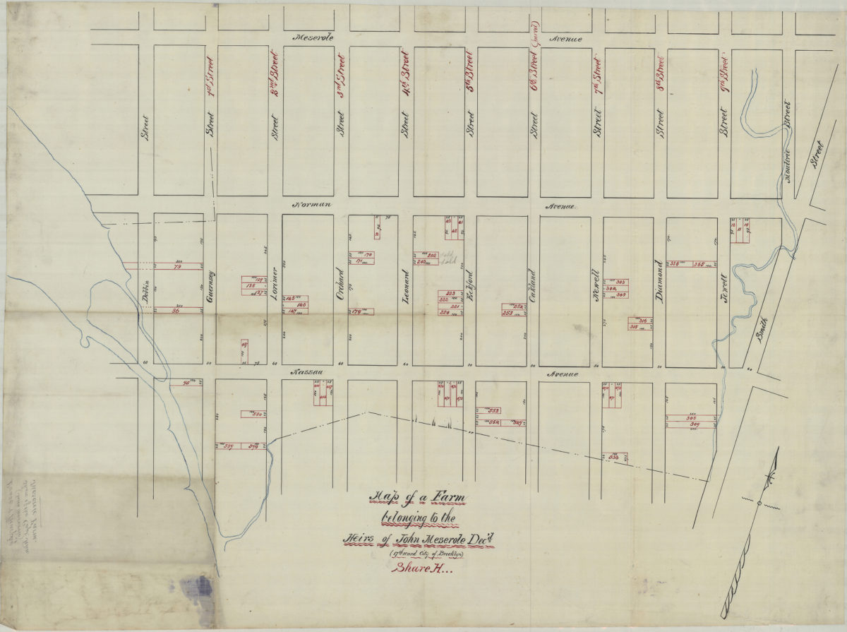
Map of a farm belonging to the heirs of John Meserole, dec’d. (17th Ward, city of Brooklyn), Share H
Map of a farm belonging to the heirs of John Meserole, dec’d. (17th Ward, city of Brooklyn), Share H
[18??]
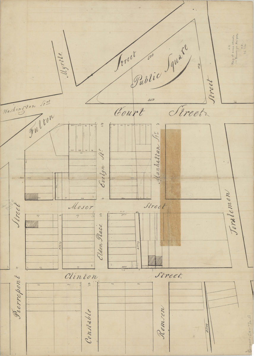
[Map of area roughly bounded by Fulton Street, Joralemon St., Clinton St. and Pierrepont St.].
[Map of area roughly bounded by Fulton Street, Joralemon St., Clinton St. and Pierrepont St.].
[18??]
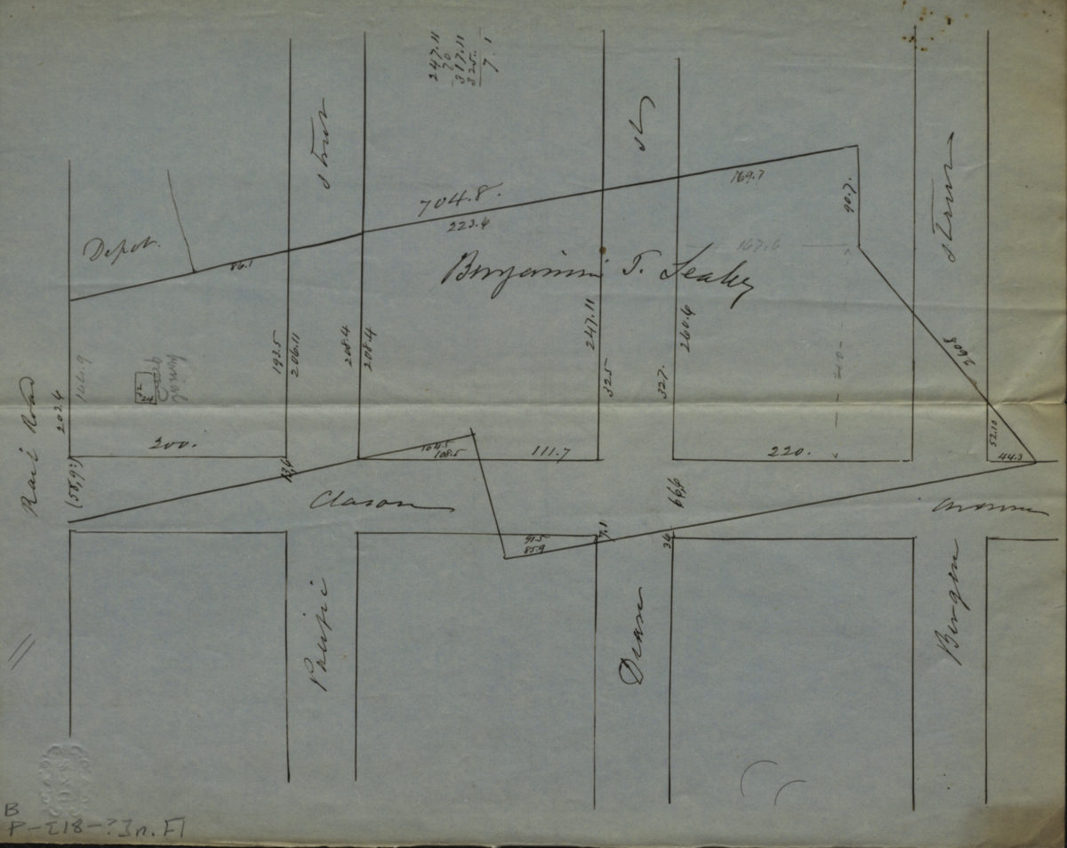
[Map of Atlantic Ave., Pacific St., Dean St., and Bergen St. at Classon Ave.].
[Map of Atlantic Ave., Pacific St., Dean St., and Bergen St. at Classon Ave.].
[18??]
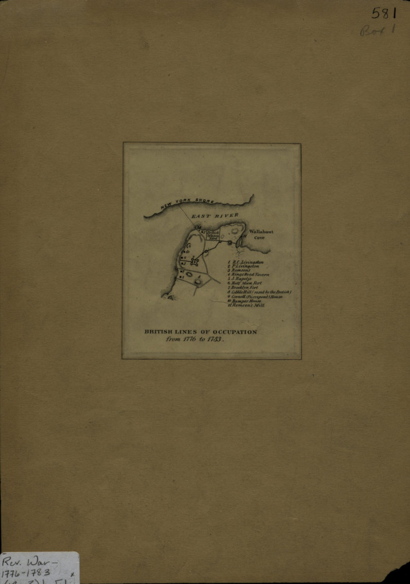
British lines of occupation from 1776 to 1783
British lines of occupation from 1776 to 1783
[18??]
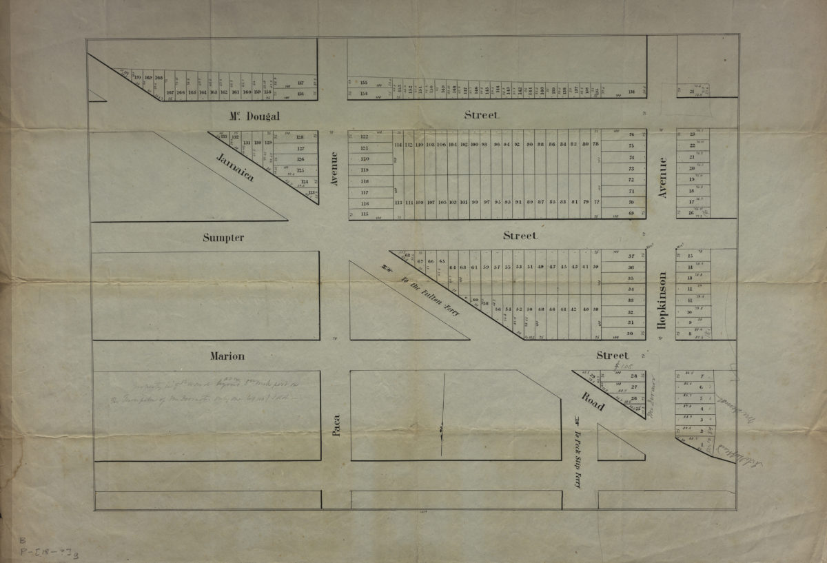
[Map of area bounded by McDougal Street, Hopkinson Avenue, and Jamaica Road]
[Map of area bounded by McDougal Street, Hopkinson Avenue, and Jamaica Road]
[18??]
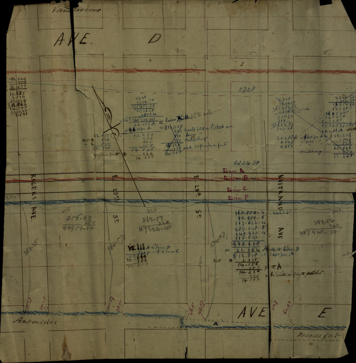
Map of Cortelyou Farm lots, Garret Vanderveer, Flatbush
Map of Cortelyou Farm lots, Garret Vanderveer, Flatbush
[18??]
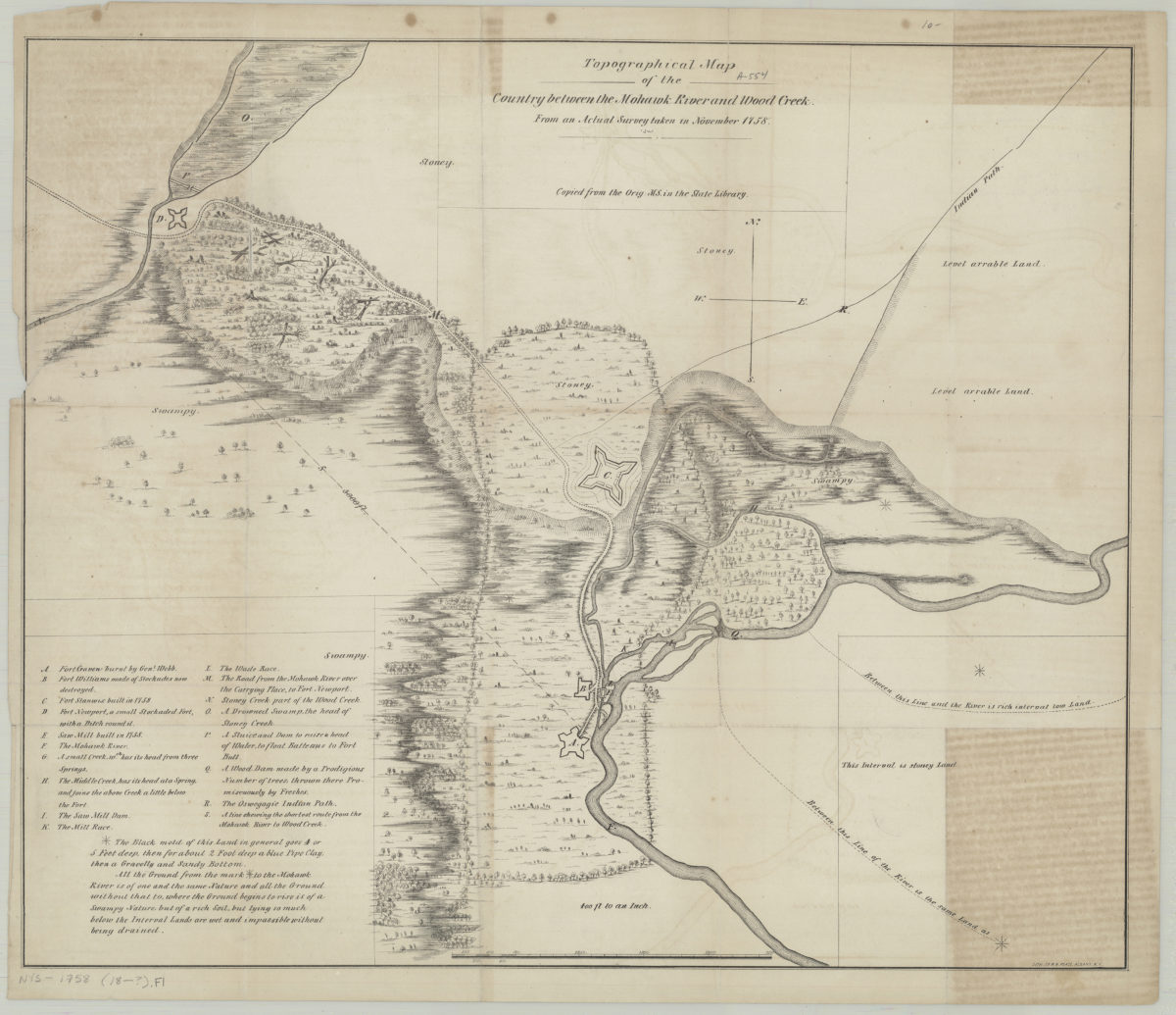
Topographical map of the country between the Mohawk River and Wood Creek: from an actual survey taken in November, 1758
Topographical map of the country between the Mohawk River and Wood Creek: from an actual survey taken in November, 1758
[18??]
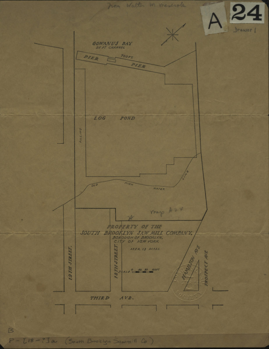
Property of the South Brooklyn Saw Mill Company, borough of Brooklyn, city of New York
Property of the South Brooklyn Saw Mill Company, borough of Brooklyn, city of New York
[18??]
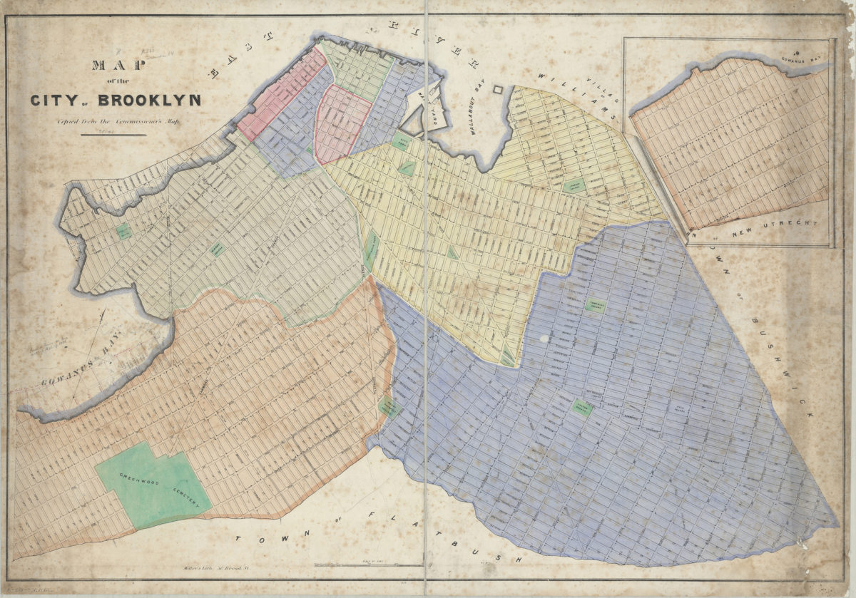
Map of the city of Brooklyn: copied from the Commissioner’s map
Map of the city of Brooklyn: copied from the Commissioner’s map
[18??]
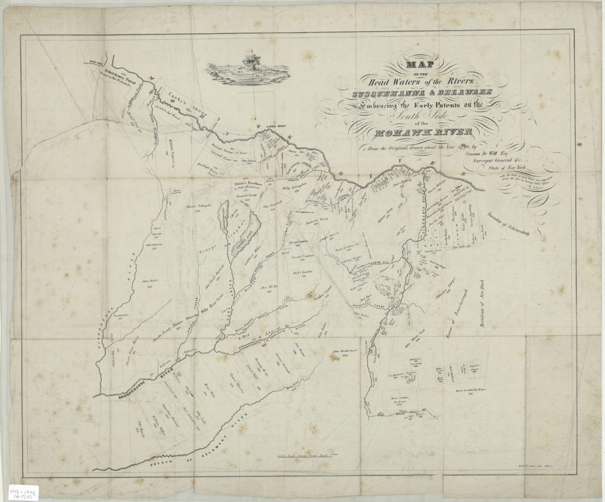
Map of the head waters of the rivers Susquehanna & Delaware: embracing the early patents on the south side of the Mohawk River : from the original, drawn about the year 1790: by Simeon DeWitt, Esq. … ;
Map of the head waters of the rivers Susquehanna & Delaware: embracing the early patents on the south side of the Mohawk River : from the original, drawn about the year 1790: by Simeon DeWitt, Esq. … ;
[18??]
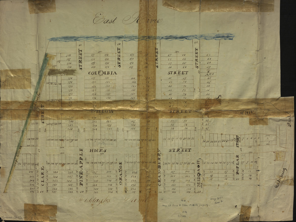
Map of Jacob & John M. Hicks property
Map of Jacob & John M. Hicks property
[18??]
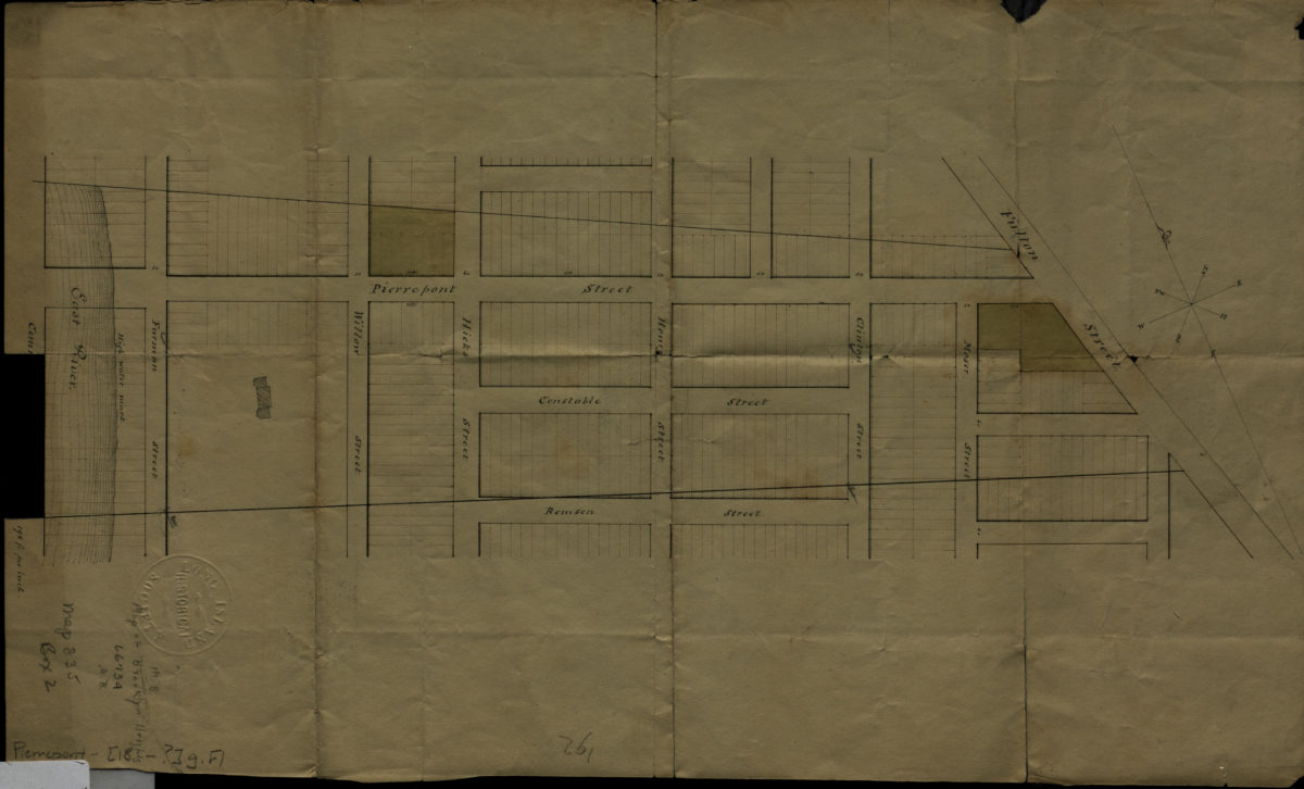
[Map of area bounded by Remsen St., Fulton St., Pierrepont St. and Commerce St.].
[Map of area bounded by Remsen St., Fulton St., Pierrepont St. and Commerce St.].
[18??]
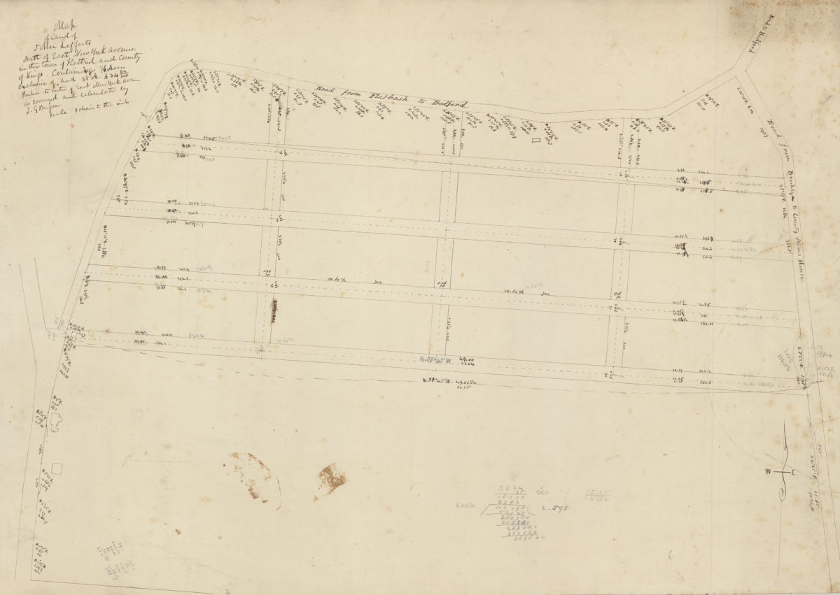
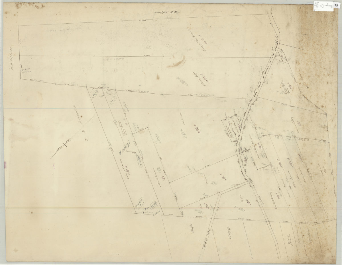
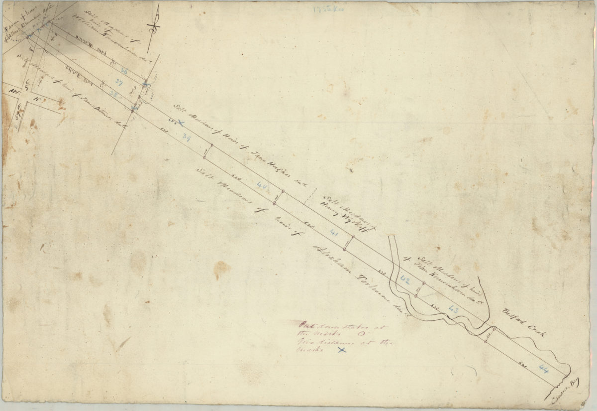
Map of land of John Lefferts, north of East New York Avenue in the town of Flatbush and county of Kings: containing 76 acres exclusive of, and 78 A. 234 64/100 perches to centre of East New York Avenue, as surveyed and calculated: by T.G. Bergen
Map of land of John Lefferts, north of East New York Avenue in the town of Flatbush and county of Kings: containing 76 acres exclusive of, and 78 A. 234 64/100 perches to centre of East New York Avenue, as surveyed and calculated: by T.G. Bergen
[18??]
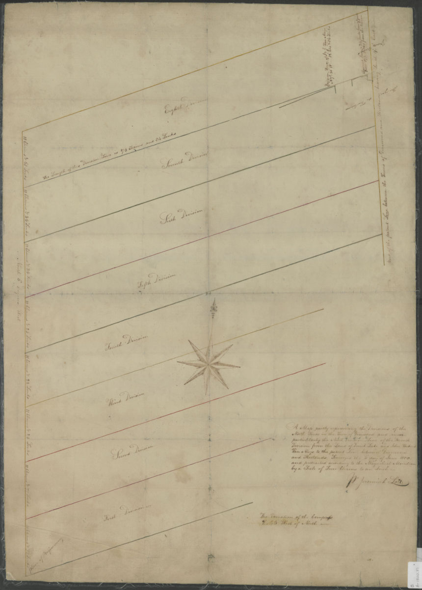
A map partly representing the divisions of the north woods in the town of Gravesend and more particularly the north division line of the seventh division from the land of Derick Lake and John Verkirk Van Nuys June, 1800
A map partly representing the divisions of the north woods in the town of Gravesend and more particularly the north division line of the seventh division from the land of Derick Lake and John Verkirk Van Nuys June, 1800
1800
[Map of Long Island, from Greenwood Cemetery to Brentwood]
[Map of Long Island, from Greenwood Cemetery to Brentwood]
[18??]
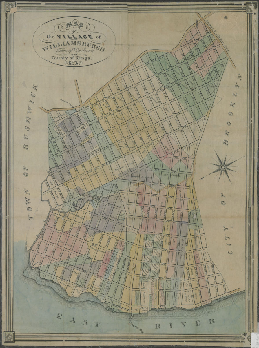
Map of the village of Williamsburgh, town of Bushwick, and county of Kings, L.I.
Map of the village of Williamsburgh, town of Bushwick, and county of Kings, L.I.
[18??]
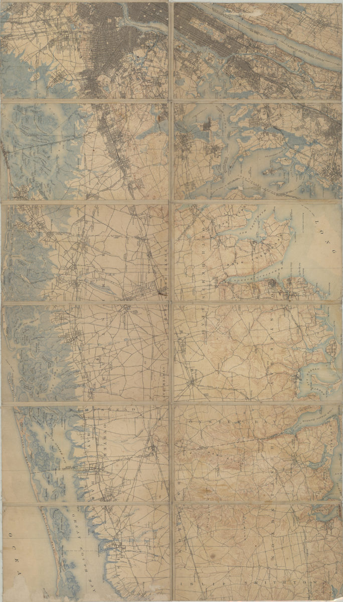
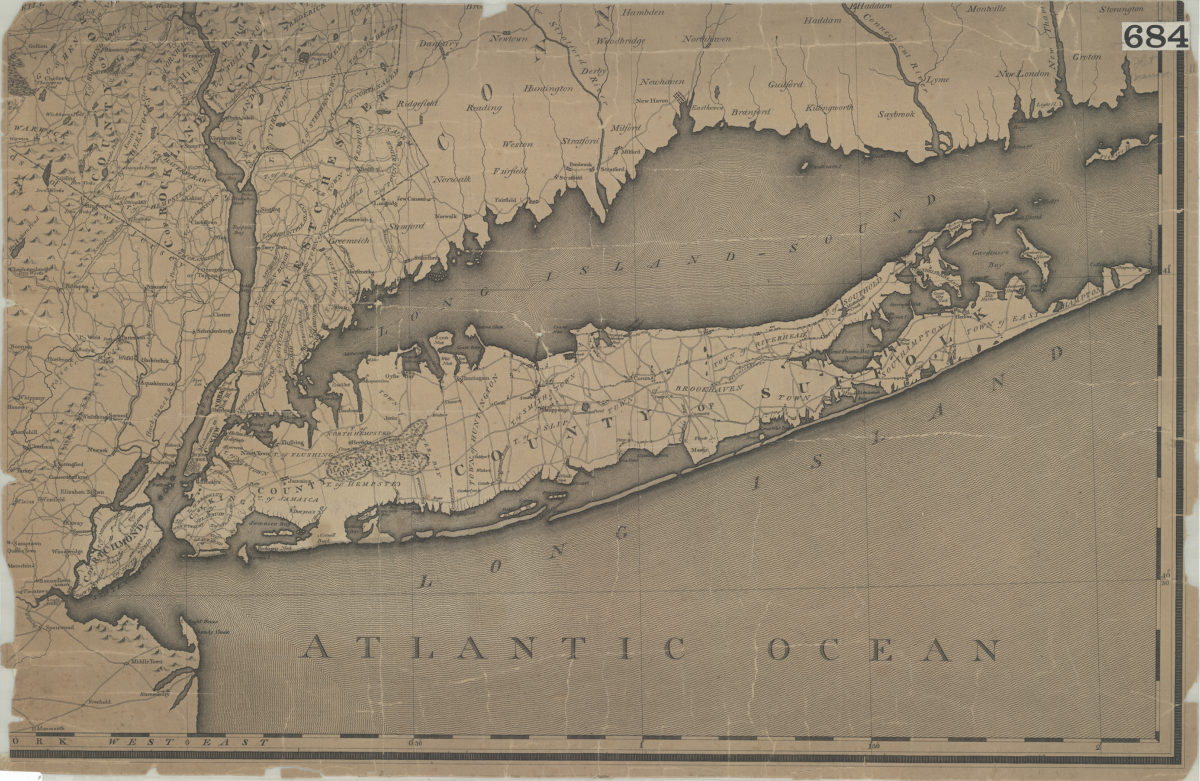
[Map of Long Island, the New York Metropolitan Area, and the southern coast of Connecticut]
[Map of Long Island, the New York Metropolitan Area, and the southern coast of Connecticut]
[18??]
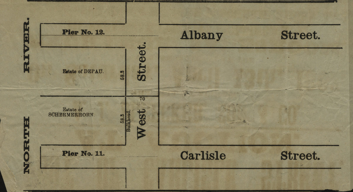
[Map showing area north from Carlisle St. to Albany St. and east from the North River to approximately West St.].
[Map showing area north from Carlisle St. to Albany St. and east from the North River to approximately West St.].
[18??]
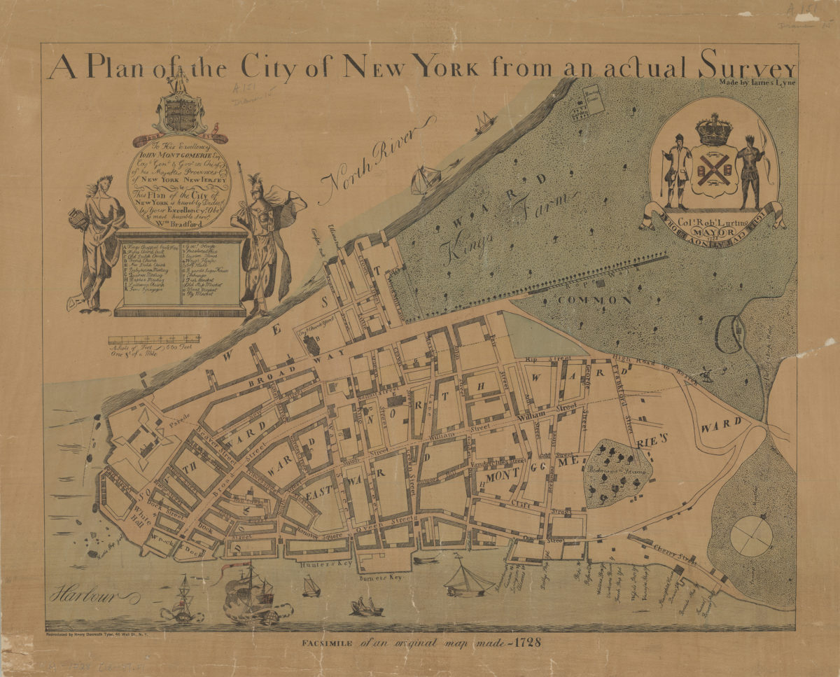
A plan of the city of New York from an actual survey: made by Iames [i.e. James] Lyne
A plan of the city of New York from an actual survey: made by Iames [i.e. James] Lyne
[18??]
[Map of Dyker Meadows in the town of New Utrecht]
[Map of Dyker Meadows in the town of New Utrecht]
[18??]
[Land of John Lott at Flatbush Avenue and Montgomery Street]
[Land of John Lott at Flatbush Avenue and Montgomery Street]
[18??]
[Map of area bounded by 71st Street, 2nd Avenue, 74th Street, and 1st Avenue]
[Map of area bounded by 71st Street, 2nd Avenue, 74th Street, and 1st Avenue]
[18??]
[Map of area bounded by 31st Street, 8th Avenue, 40th Street and 2nd Avenue]
[Map of area bounded by 31st Street, 8th Avenue, 40th Street and 2nd Avenue]
[18??]
[Map of area bounded by 46th Street, 8th Avenue, 48th Street and 7th Avenue]
[Map of area bounded by 46th Street, 8th Avenue, 48th Street and 7th Avenue]
[18??]
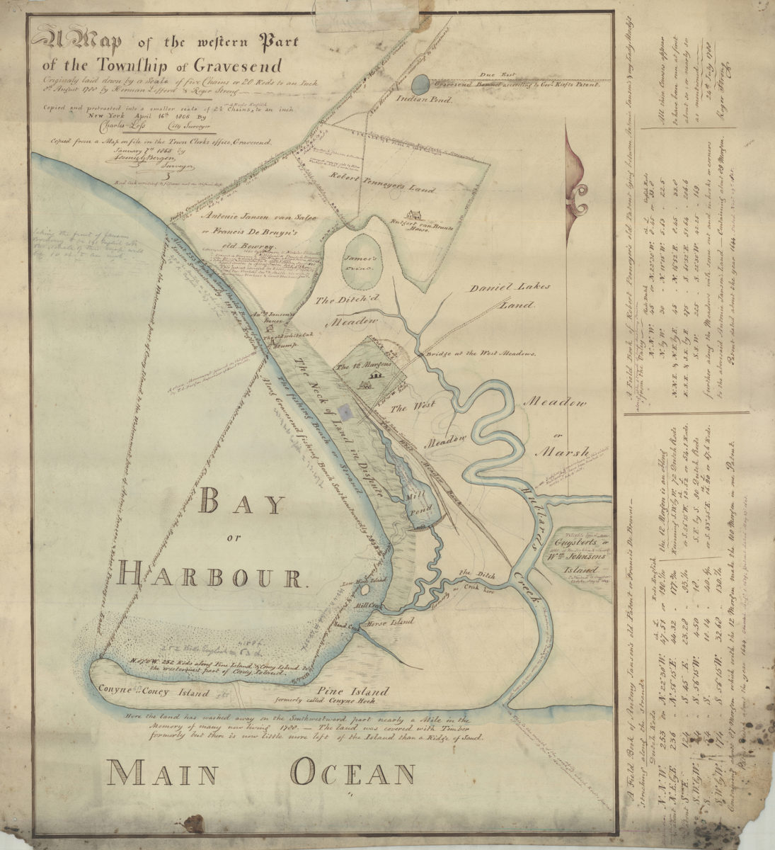
Map of the western part of the Township of Gravesend originally laid down by a scale of five chains or 20 rods to an inch, 8th August 1788 by Herman Lefford & Roger Strong:New York City, April 16th 1806
Map of the western part of the Township of Gravesend originally laid down by a scale of five chains or 20 rods to an inch, 8th August 1788 by Herman Lefford & Roger Strong:New York City, April 16th 1806
[18??]
Sketch of New Utrecht from Dripps map
Sketch of New Utrecht from Dripps map
[18??]
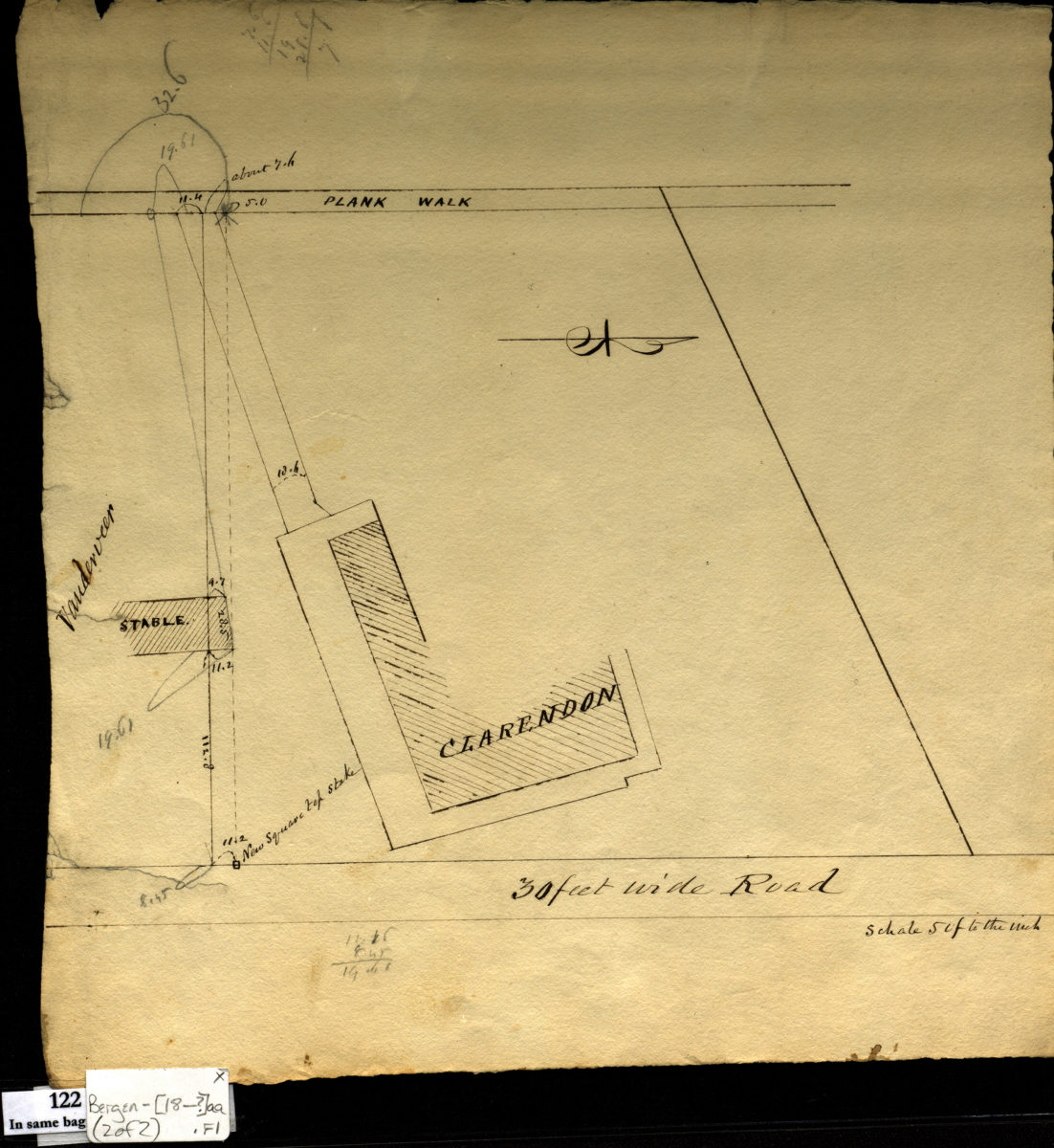
[Survey maps of Kings County Penitentiary Grounds and Vanderveer encroachment onto Clarendon property]
[Survey maps of Kings County Penitentiary Grounds and Vanderveer encroachment onto Clarendon property]
[18??]
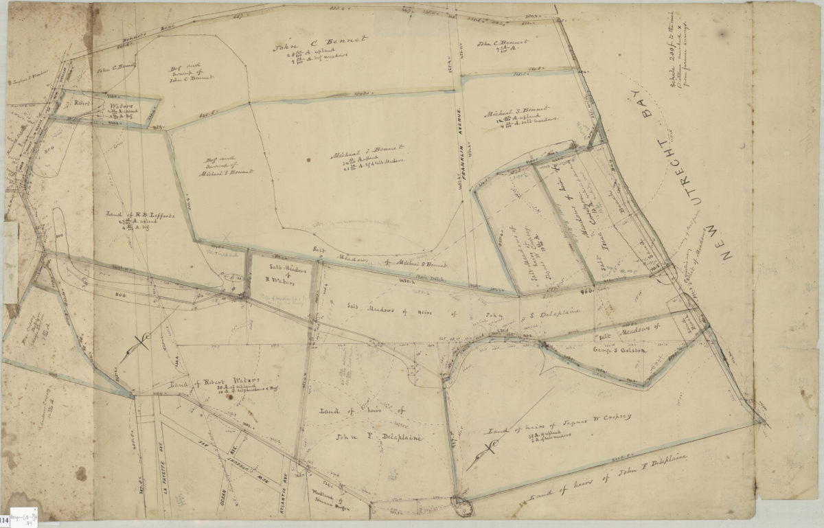
Land of G. Van Brunt, Sieger, Delaplaine, A. Cropsey & c
Land of G. Van Brunt, Sieger, Delaplaine, A. Cropsey & c
[18??]
Map of the western part of the Township of Gravesend originally laid down by a scale of five chains or 20 rods to an inch, 8th August 1788 by Herman Lefford & Roger Strong: April 16th 1806
Map of the western part of the Township of Gravesend originally laid down by a scale of five chains or 20 rods to an inch, 8th August 1788 by Herman Lefford & Roger Strong: April 16th 1806
[18??]
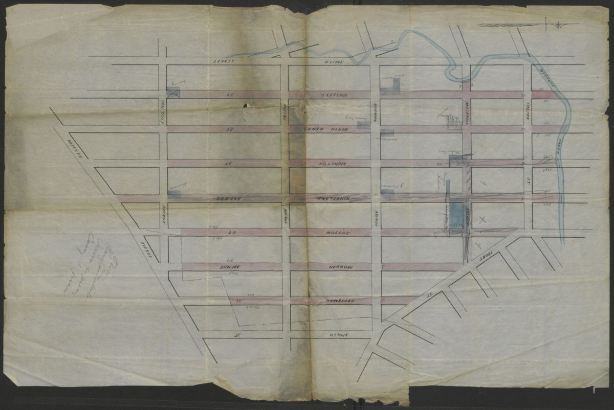
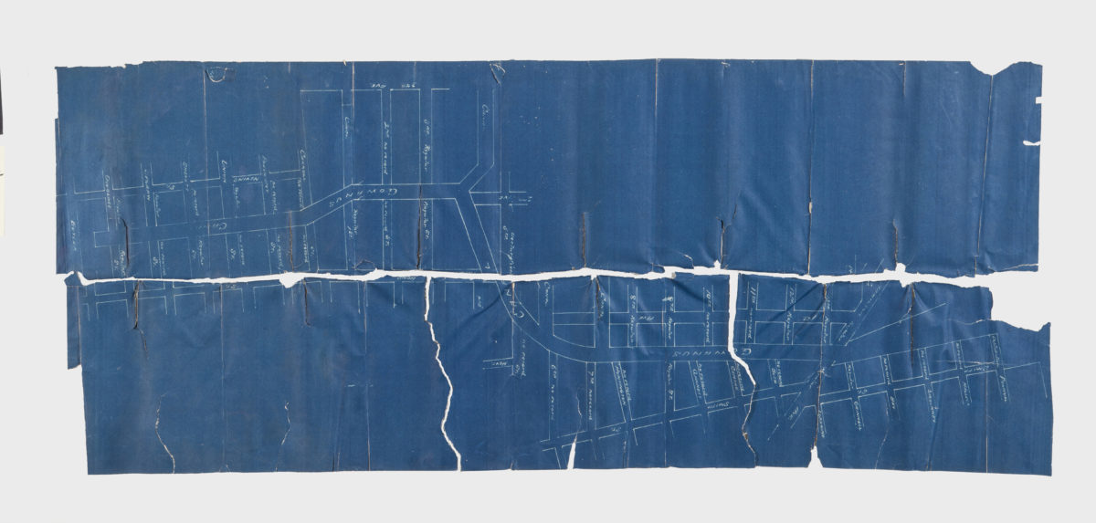
[Map showing street grid, existing buildings, and the course of Wykoff Creek in Greenpoint, Brooklyn]
[Map showing street grid, existing buildings, and the course of Wykoff Creek in Greenpoint, Brooklyn]
[18??]
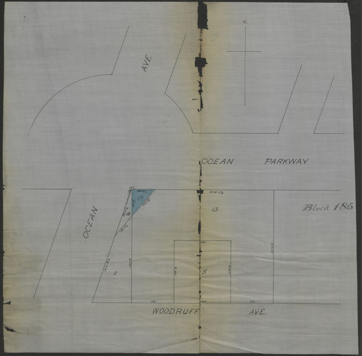
[Map showing property at intersection of Ocean Avenue and Ocean Parkway in Brooklyn, N.Y.]
[Map showing property at intersection of Ocean Avenue and Ocean Parkway in Brooklyn, N.Y.]
[18??]
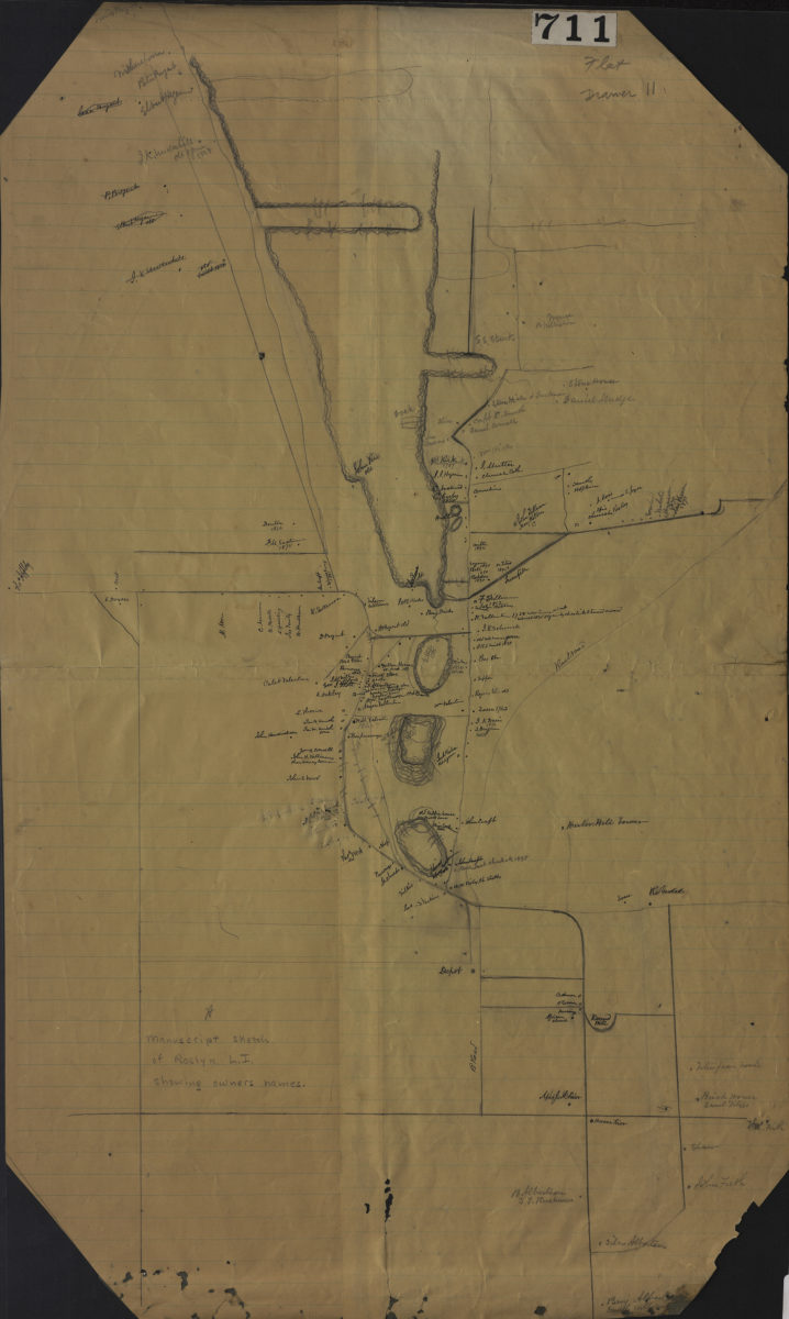
Manuscript sketch of Roslyn L.I. showing owners names
Manuscript sketch of Roslyn L.I. showing owners names
[18??]
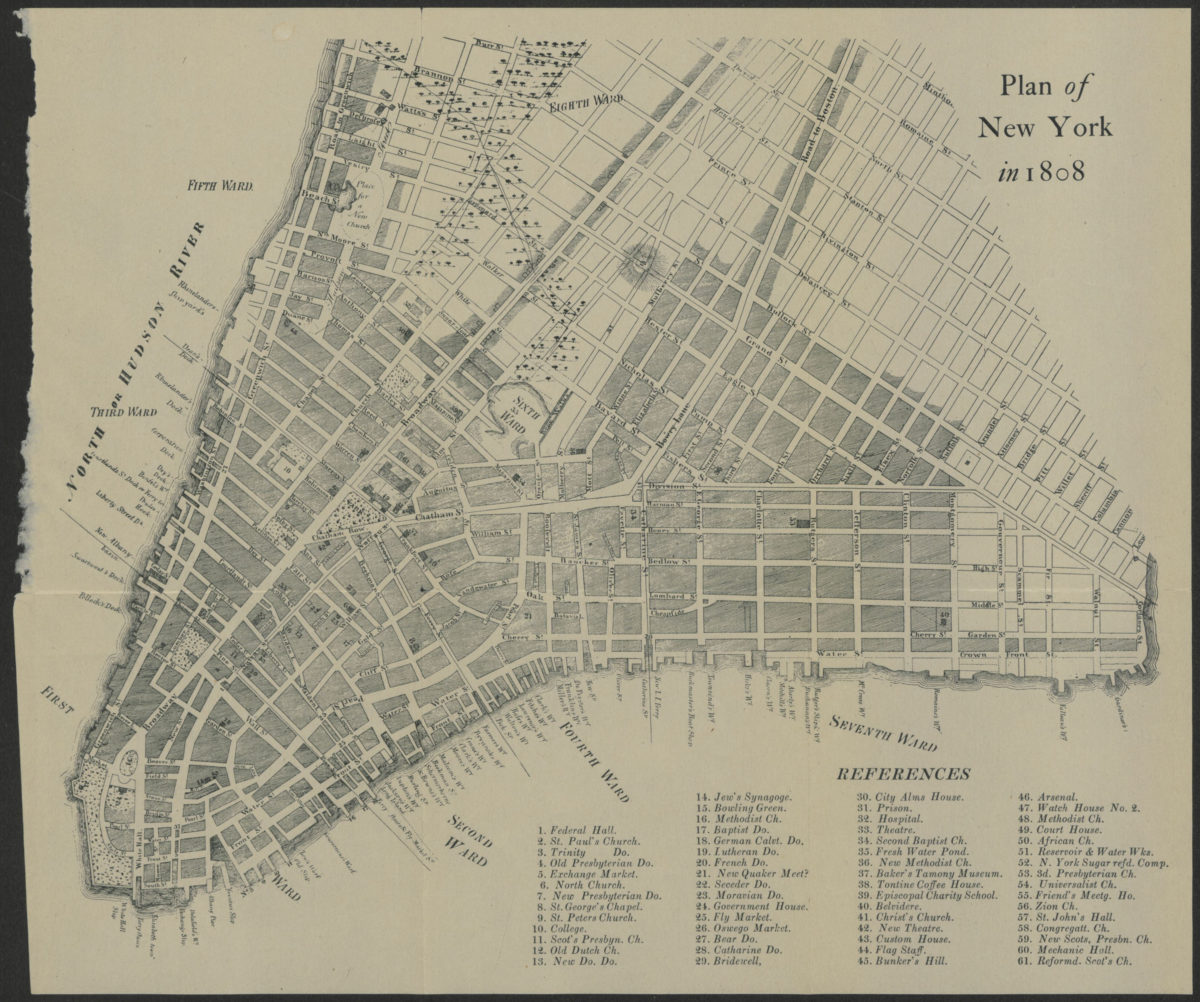
Plan of New York in 1808
Plan of New York in 1808
[18??]
[Map showing the intersection of Gowanus Creek with Gowanus Canal, Brooklyn, N.Y.]
[Map showing the intersection of Gowanus Creek with Gowanus Canal, Brooklyn, N.Y.]
[18??]
[Survey maps of Flatlands]
[Survey maps of Flatlands]
[18??]
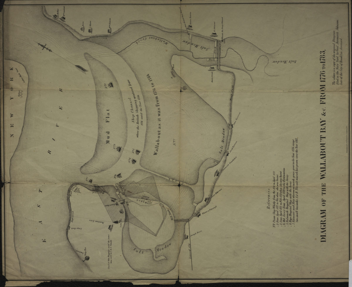
Diagram of the Wallabout Bay &c. from 1776 to 1783
Diagram of the Wallabout Bay &c. from 1776 to 1783
[18??]
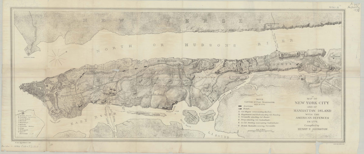
Map of New York City and of Manhattan Island with the American defences in 1776: compiled by Henry P. Johnston ; F. von Egloffstein del
Map of New York City and of Manhattan Island with the American defences in 1776: compiled by Henry P. Johnston ; F. von Egloffstein del
[18??]
[Map of Long Island covering area east from Brooklyn to Springfield and north from Flatlands to Flushing]
[Map of Long Island covering area east from Brooklyn to Springfield and north from Flatlands to Flushing]
[18??]
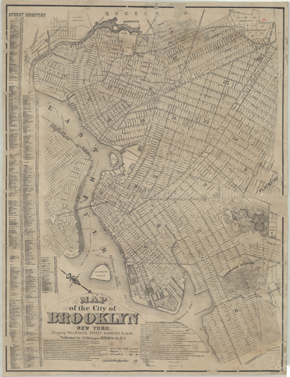
Map of the city of Brooklyn, New York: showing railroads, street numbers &c.&c.&c
Map of the city of Brooklyn, New York: showing railroads, street numbers &c.&c.&c
[18??]
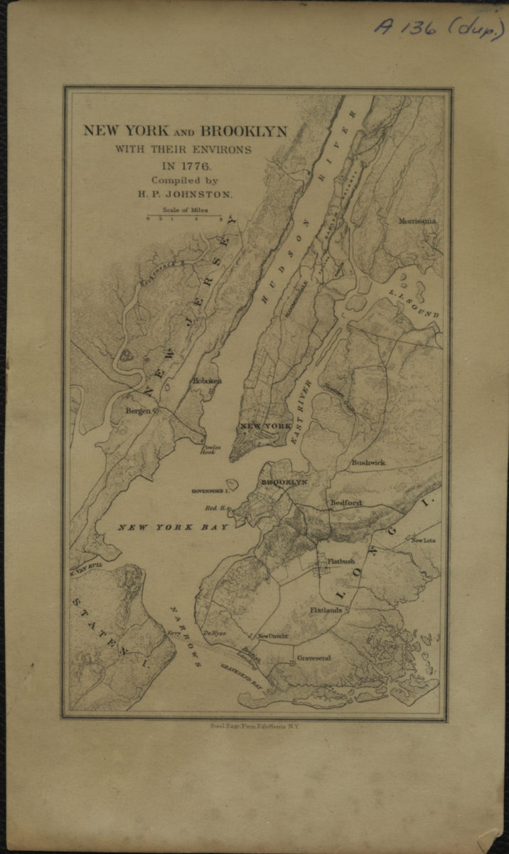
New York and Brooklyn with their environs in 1776: compiled by H.P. Johnston
New York and Brooklyn with their environs in 1776: compiled by H.P. Johnston
[18??]
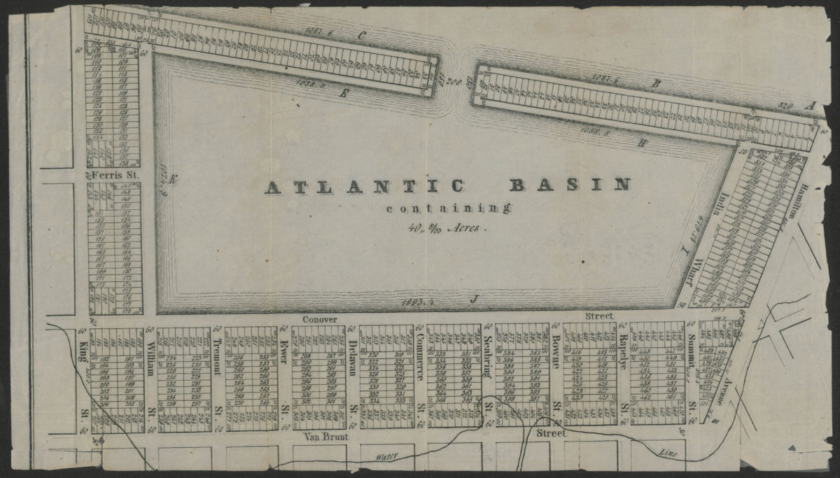
Atlantic Basin containing 40” 86/100 acres
Atlantic Basin containing 40” 86/100 acres
[18??]
Map of New Netherland with a view of New Amsterdam (now New York), A.D. 1656
Map of New Netherland with a view of New Amsterdam (now New York), A.D. 1656
[18??]
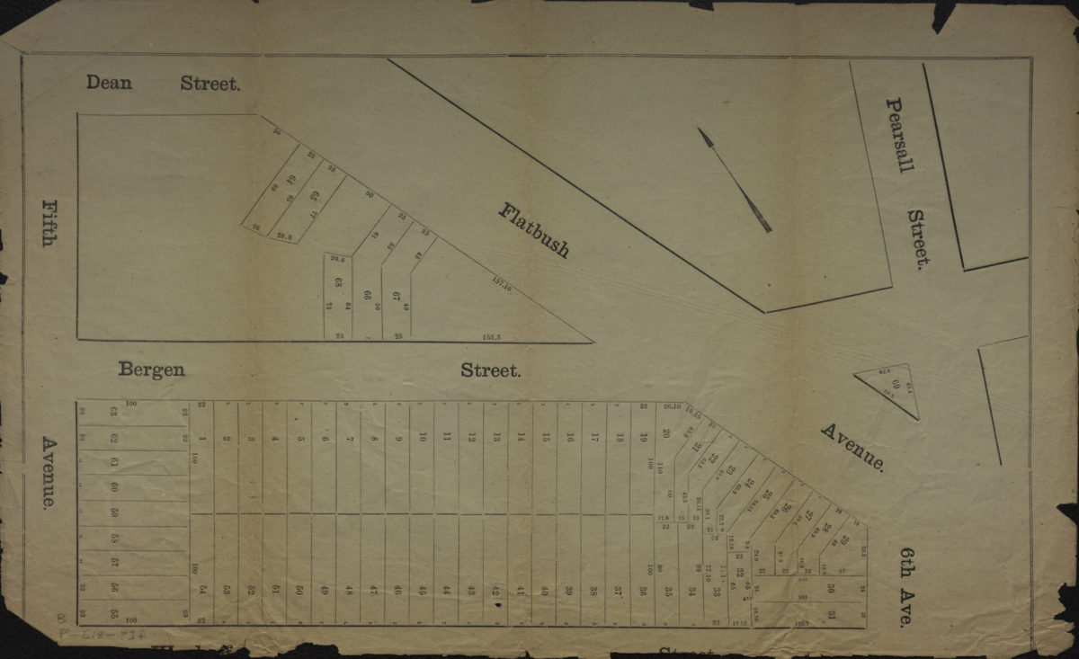
[Map of area bounded by 5th Ave., Dean St., Pearsall St., and Wyckoff St.].
[Map of area bounded by 5th Ave., Dean St., Pearsall St., and Wyckoff St.].
[18??]
Map of the city of Brooklyn: copied from the Commissioner’s map
Map of the city of Brooklyn: copied from the Commissioner’s map
[18??]
Map of the election districts of the Town of Gravesend, Kings County, N.Y., polling places, Town Hall
Map of the election districts of the Town of Gravesend, Kings County, N.Y., polling places, Town Hall
[18??]
Grades on street in Richards tract, Bay Ridge
Grades on street in Richards tract, Bay Ridge
[18??]
Opening map and tracing of 22nd Ave
Opening map and tracing of 22nd Ave
[18??]
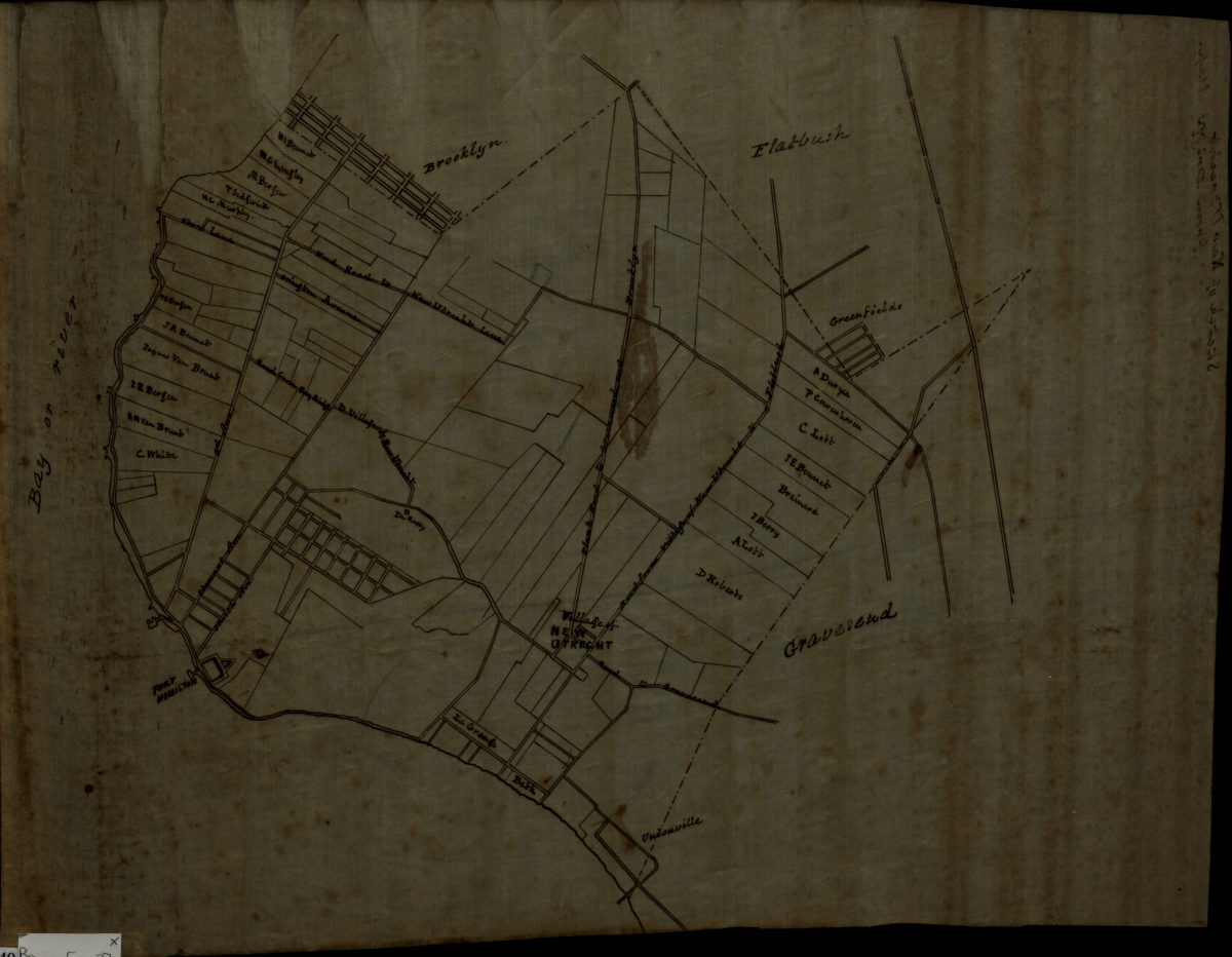
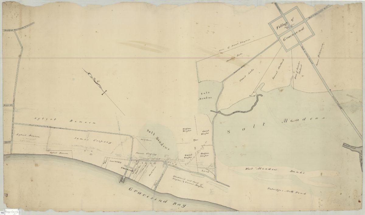
Map of territory near the Bay from the Village of New Utrecht to Gravesend & Coney Island
Map of territory near the Bay from the Village of New Utrecht to Gravesend & Coney Island
[18??]
Map of Bay Ridge
Map of Bay Ridge
[18??]
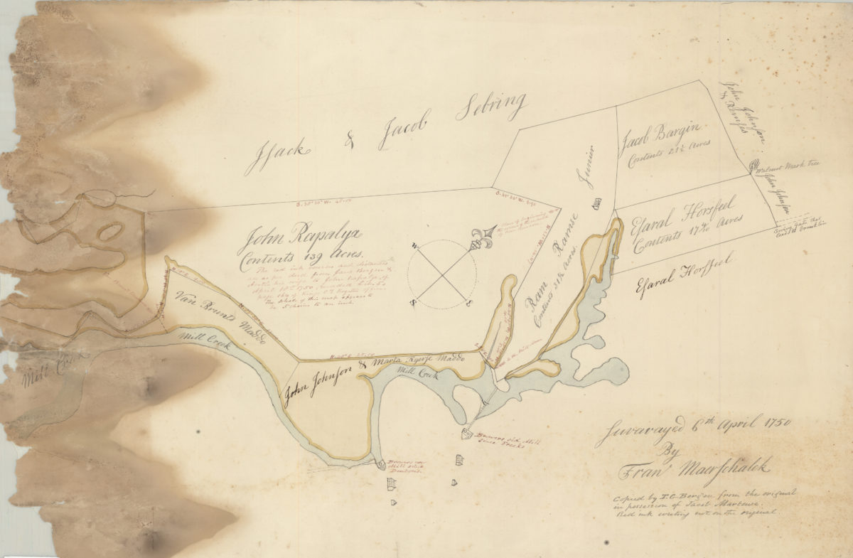
[Map of area around Gowanus Creek]: surveyed 6th April 1750 by Fran Maerschalck, copied by T. G. Bergen from the original in the possession of John Martense
[Map of area around Gowanus Creek]: surveyed 6th April 1750 by Fran Maerschalck, copied by T. G. Bergen from the original in the possession of John Martense
[18??]
Previous
1
2
3
4
5
6
7
8
9
10
11
12
13
14
15
16
17
18
19
20
21
22
23
24
25
26
27
28
29
30
Next