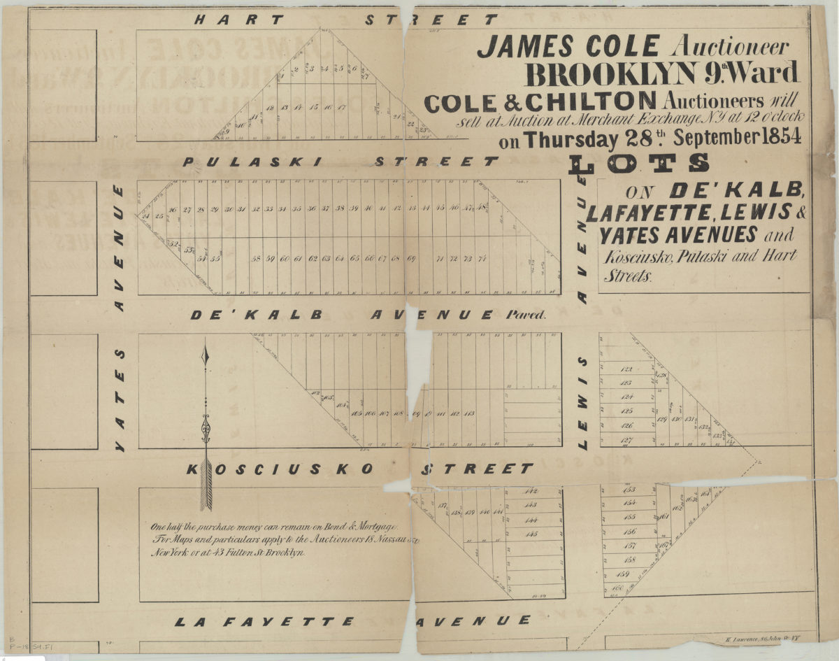
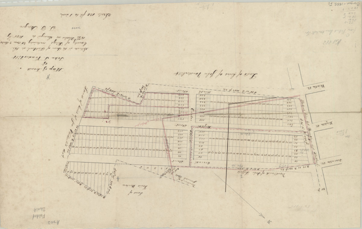
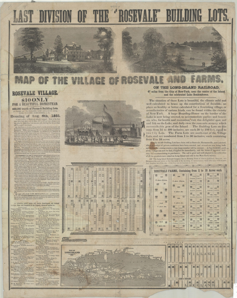
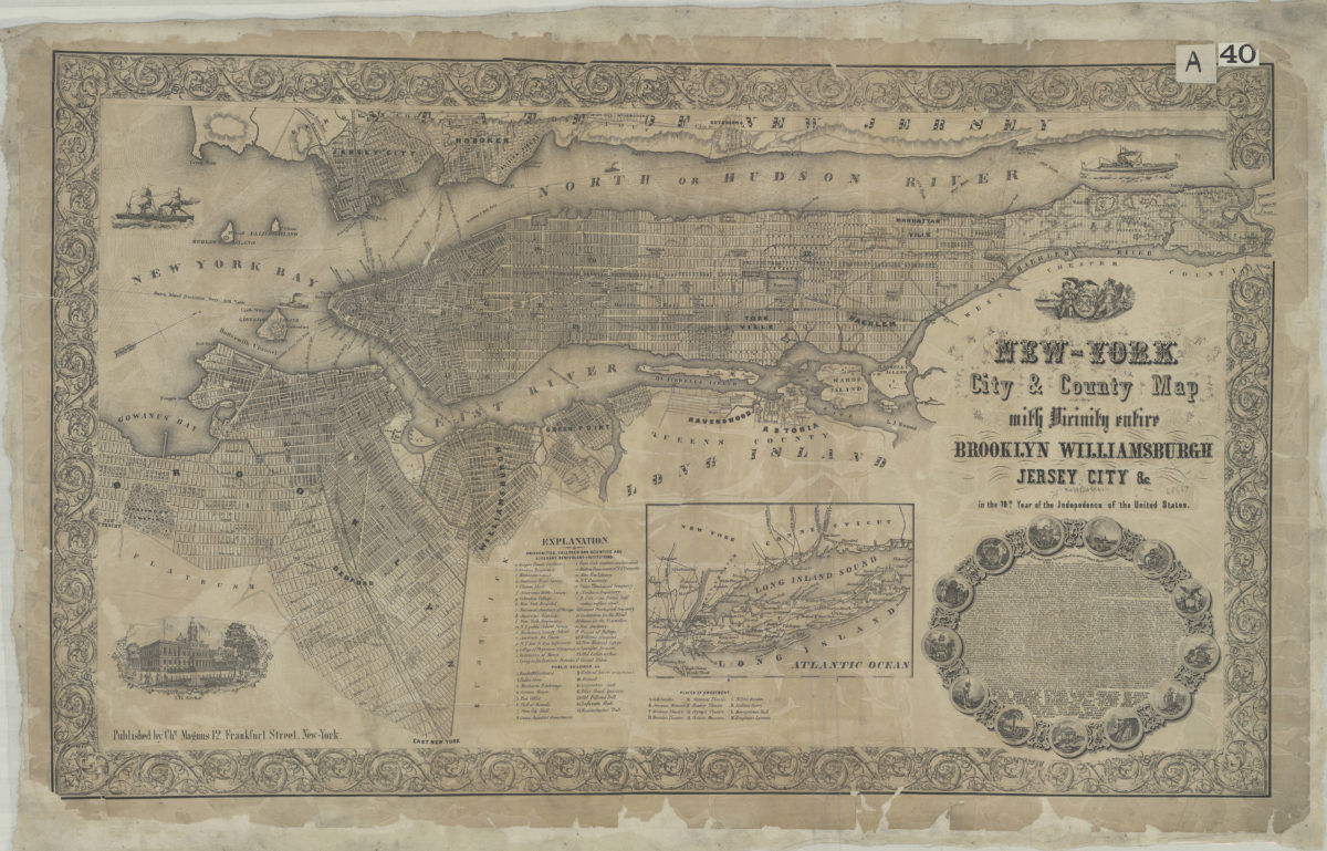
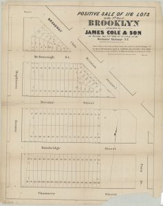
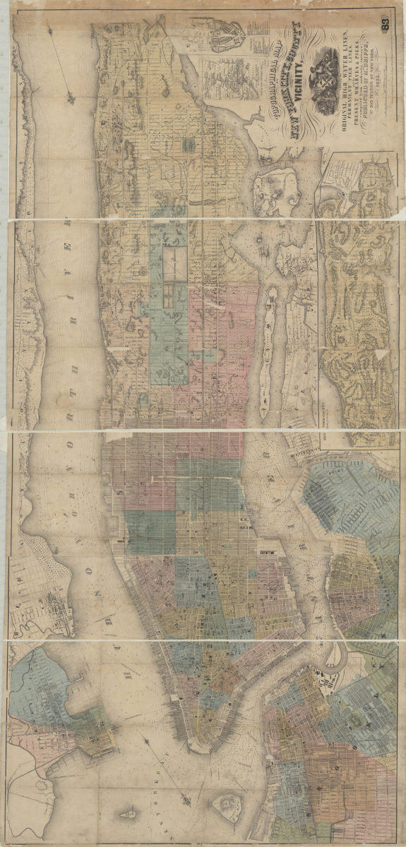
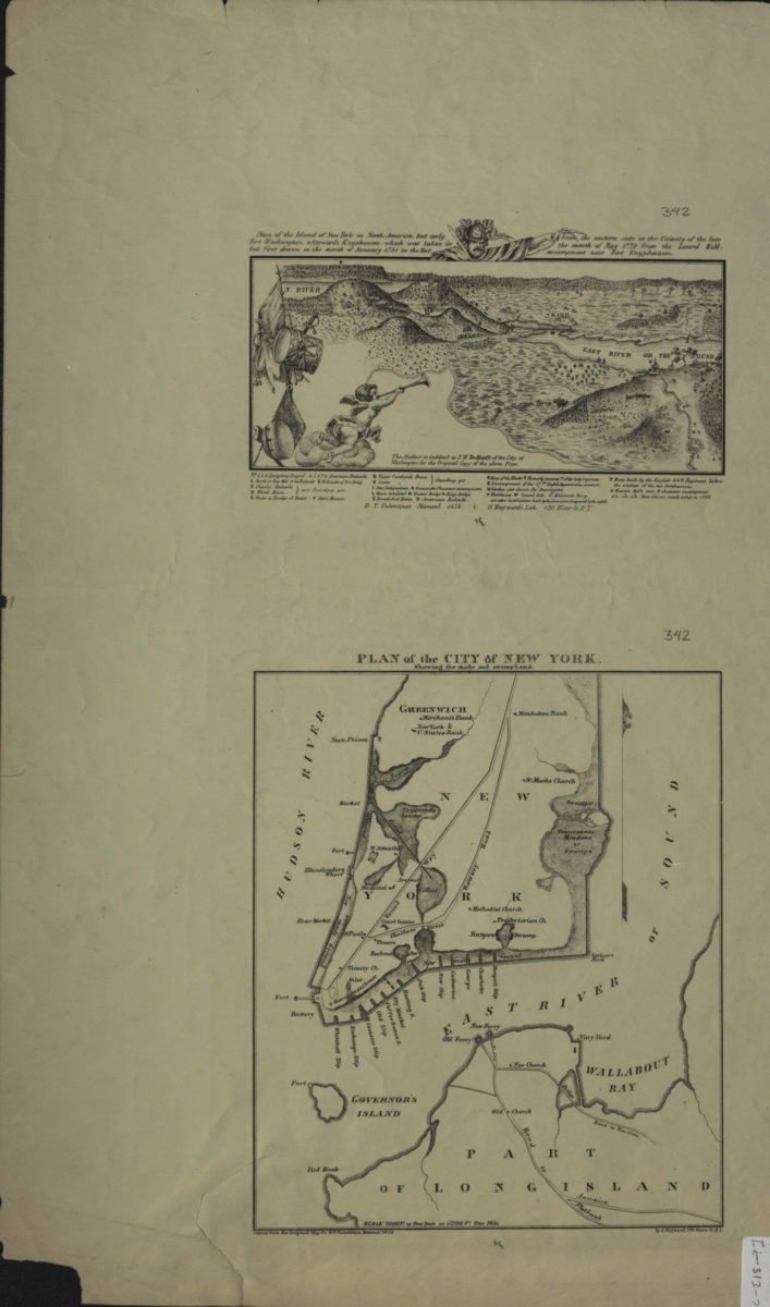
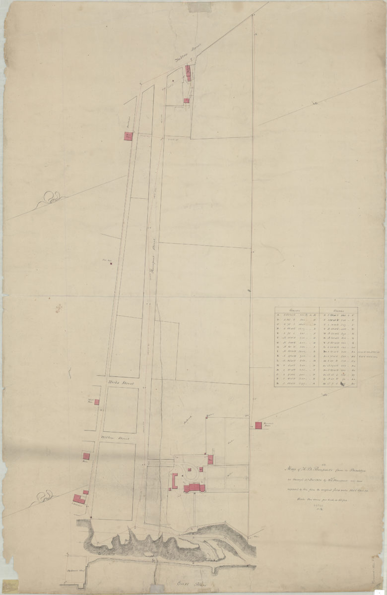
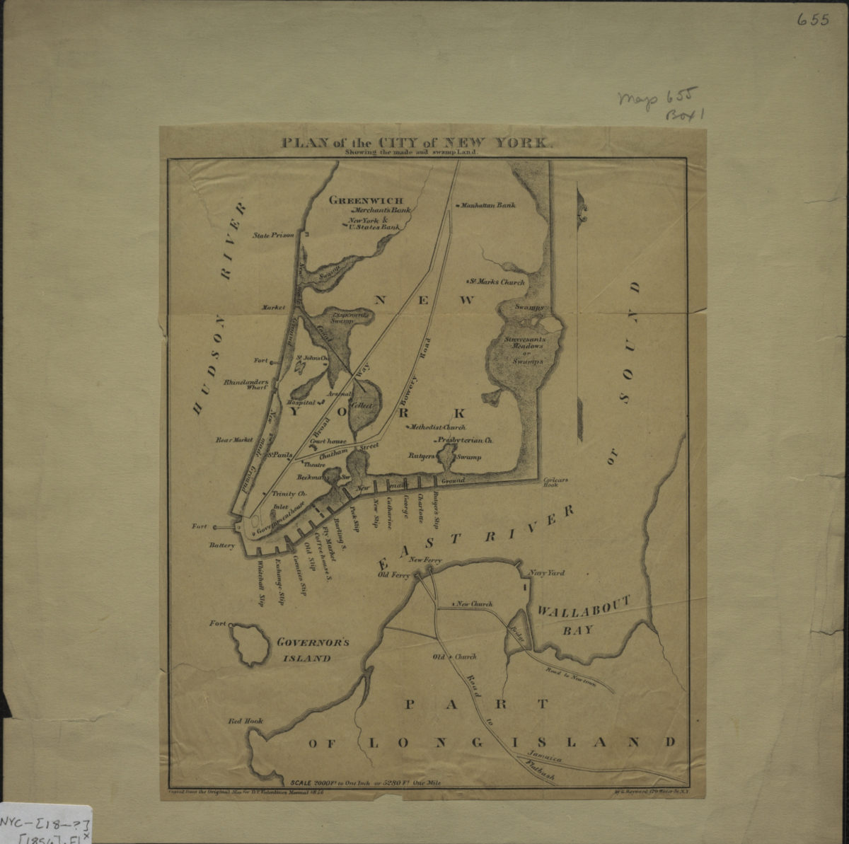
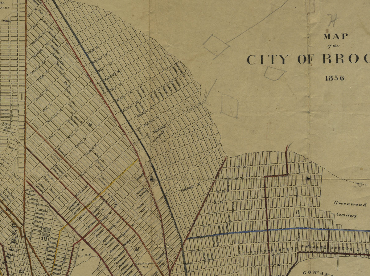
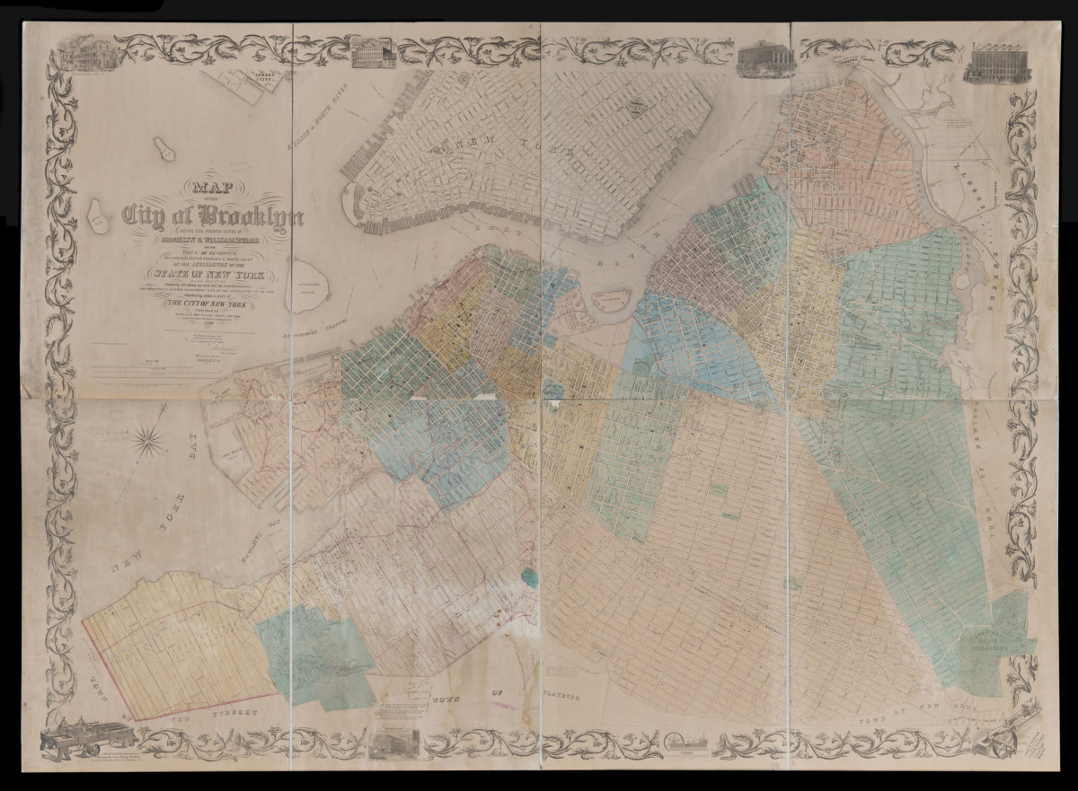
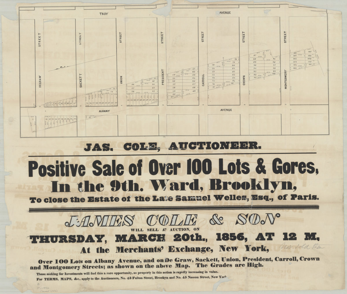
Center for Brooklyn History
Map Collections
Search
About
Othmer Library & Archives
Submit search query
Browse 1493 records
Location
Abingdon Square (New York, N.Y.)
1
Adirondack Mountains (N.Y.)
2
Adirondack Park (N.Y.)
1
Albany (N.Y.)
3
Albany County (N.Y.)
1
Albion (Oswego County : Town)
1
Amagansett (N.Y.)
1
Amityville (N.Y.)
1
Annastown (N.Y.)
1
Astoria (New York, N.Y.)
4
Atlantic Basin (New York, N.Y.)
3
Atlantic Coast (North America)
6
Atlantic Ocean.
1
Atlantic States
2
Auburn (N.Y.)
1
Babylon (N.Y. : Town)
2
Babylon (N.Y.)
1
Bath Beach (New York, N.Y.)
8
Battery Park (New York, N.Y.)
3
Bay Ridge (New York, N.Y.)
108
Bay Ridge Park (New York, N.Y.)
1
Bedford (N.Y. : Town)
1
Bedford-Stuyvesant (New York, N.Y.)
67
Bellerose (New York, N.Y.)
1
Belt Parkway (New York, N.Y.)
1
Bensonhurst (New York, N.Y.)
17
Bergen Beach (New York, N.Y.)
3
Bergen County (N.J.)
6
Block Island (R.I. : Island)
2
Blythebourne (New York, N.Y.)
1
Boerum Hill (New York, N.Y.)
6
Borough Park (New York, N.Y.)
23
Boylston (N.Y.)
1
Brandon (N.Y.)
1
Bridgehampton (N.Y.)
1
Brighton Beach (New York, N.Y.)
4
Brightwaters (N.Y.)
1
Bronx (New York, N.Y.)
10
Brookhaven (N.Y. : Town)
3
Brookhaven (N.Y.)
2
Brooklyn (New York, N.Y.)
891
Brooklyn Botanic Garden
2
Brooklyn Heights (New York, N.Y.)
76
Brooklyn-Battery Bridge (New York, N.Y.)
1
Brooklyn-Queens Expressway (New York, N.Y.)
3
Brownsville (New York, N.Y.)
10
Buffalo (N.Y.)
3
Bushwick (New York, N.Y.)
20
Bushwick Park (New York, N.Y.)
1
Buttermilk Channel (New York, N.Y.)
1
Canarsie (New York, N.Y.)
18
Caribbean Area
2
Carroll Gardens (New York, N.Y.)
21
Carroll Park (New York, N.Y.)
1
Cemetery of the Evergreens (New York, N.Y.)
1
Central Park (New York, N.Y.)
3
Champlain Canal (N.Y.)
1
Champlain, Lake
1
City Hall Park (New York, N.Y.)
1
Clermont (N.Y. : Town)
1
Clinton County (N.Y.)
1
Clinton Hill (New York, N.Y.)
10
Cobble Hill (New York, N.Y.)
7
Cold Spring Harbor (N.Y.)
1
College Point (New York, N.Y.)
2
Columbia County (N.Y.)
1
Columbia Street Waterfront District (New York, N.Y.)
3
Columbus Park (New York, N.Y.)
1
Commodore Barry Park (New York, N.Y.)
1
Coney Island (New York, N.Y.)
22
Connecticut
7
Connecticut River
1
Constable (N.Y.)
1
Corona (New York, N.Y.)
2
Cortelyou Farm (New York, N.Y.)
1
Cowenhoven Homestead (Brooklyn, New York, N.Y.)
1
Croton Aqueduct (N.Y.)
3
Croton River Watershed (N.Y.)
2
Crown Heights (New York, N.Y.)
25
Cypress Hills (New York, N.Y.)
8
David Johnson Farm (New York, N.Y.)
1
Delaware County (N.Y.)
1
Delaware River Valley (N.Y.-Del. and N.J.)
1
Denmark (N.Y.)
1
Dickinson (N.Y.)
2
Ditmas Park (New York, N.Y.)
1
Douglaston (New York, N.Y.)
1
Downtown Brooklyn (New York, N.Y.)
29
Duane Street Park (New York, N.Y.)
1
DUMBO Historic District (New York, N.Y.)
7
Dunkirk (N.Y.)
1
Dutchess County (N.Y.)
2
Dyker Heights (New York, N.Y.)
23
East (U.S.)
1
East Elmhurst (New York, N.Y.)
2
East Flatbush (New York, N.Y.)
23
East Hampton (N.Y.)
1
East Harlem (New York, N.Y.)
1
East Midwood (New York, N.Y.)
1
East New York (New York, N.Y.)
16
East Patchogue (N.Y.)
1
East River (N.Y.)
3
Elmhurst (New York, N.Y.)
1
Elmont (N.Y.)
1
Erasmus (New York, N.Y.)
1
Erie Basin (New York, N.Y.)
2
Erie Canal (N.Y.)
3
Erie County (N.Y.)
1
Essex County (N.J.)
4
Fairfield County (Conn.)
5
Far Rockaway (New York, N.Y.)
2
Farragut (New York, N.Y.)
1
ferries
1
Flatbush (New York, N.Y.)
35
Flatiron District (New York, N.Y.)
1
Flatlands (New York, N.Y.)
19
Flushing (New York, N.Y.)
13
Flushing Meadows-Corona Park (New York, N.Y.)
1
Forest Hills Gardens (New York, N.Y.)
1
Fort Brooklyn (New York, N.Y.)
1
Fort Covington (N.Y.)
1
Fort Greene (New York, N.Y.)
22
Fort Hamilton (New York, N.Y.)
31
Fort Montgomery State Historic Site (Highlands, N.Y.)
1
Fort Stanwix (Rome, N.Y.)
1
Fort Totten (N.Y.)
1
Fort Washington (New York, N.Y.)
2
Franklin County (N.Y.)
2
Freeport (N.Y.)
1
Fulton Ferry Historic District (New York, N.Y.)
5
Futurama (New York, N.Y.)
2
Gardiners Bay (N.Y.)
1
Genesee County (N.Y.)
2
Genesee River (Pa. and N.Y.)
1
George, Lake (N.Y. : Lake)
1
Germantown (N.Y. : Town)
1
Gerritsen Beach (New York, N.Y.)
2
Glen Cove (N.Y.)
1
Gowanus (New York, N.Y.)
12
Gowanus Bay (New York, N.Y.)
1
Gowanus Canal (New York, N.Y.)
5
Gramercy Park (New York, N.Y.)
1
Grand Army Plaza (Brooklyn, New York, N.Y.)
1
Gravesend (New York, N.Y.)
25
Great Neck (N.Y.)
3
Green-Wood Cemetery (New York, N.Y.)
2
Greenboro (N.Y.)
1
Greene County (N.Y.)
3
Greenpoint (New York, N.Y.)
38
Greenport (N.Y.)
1
Greenwich Village (New York, N.Y.)
1
Greenwood (New York, N.Y.)
1
Greenwood Lake Region (N.J. and N.Y.)
1
Hanover (N.H.)
1
Hanover Region (N.H.)
1
Harlem (New York, N.Y.)
1
Harrisburgh (N.Y.)
1
Hell Gate (New York, N.Y.)
2
Hempstead (N.Y.)
13
Herbert Von King Park (New York, N.Y.)
1
Hicksville (N.Y.)
1
Hinsdale (New York, N.Y.)
1
Hoboken (N.J.)
1
Holland Tunnel (Jersey City, N.J., and New York, N.Y.)
1
Hudson County (N.J.)
3
Hudson Highlands (N.Y.)
1
Hudson River (N.Y. and N.J.)
7
Hunters Point (New York, N.Y.)
2
Huntington (N.Y.)
7
Inwood (New York, N.Y.)
1
Islip (N.Y.)
5
Ithaca, N.Y.
1
Jamaica (New York, N.Y.)
8
Jamaica Bay (N.Y.)
5
Jefferson County (N.Y.)
1
Jersey City (N.J.)
4
Kensington (New York, N.Y.)
11
Kings County (New York, N.Y.)
8
Kings Highway (New York, N.Y.)
1
Kingslandville (New York, N.Y.)
1
Lakeland (N.Y.)
1
Lawrence (Mercer County, N.J. : Township)
1
Lawrence Beach (N.Y.)
1
Lebanon (N.H.)
1
Lebanon Region (N.H.)
1
Lefferts Park (New York, N.Y.)
1
Lewis County (N.Y.)
2
Lindenhurst (N.Y.)
1
Livingston (N.Y. : Town)
1
Livingston County (N.Y.)
1
Lloyd Harbor (N.Y.)
1
Long Island (N.Y.)
197
Long Island City (New York, N.Y.)
8
Long Island Sound (N.Y. and Conn.)
12
Long Island, Battle of, New York, N.Y., 1776
4
Lorraine (N.Y.)
1
Lower Bay (N.Y. and N.J.)
1
Madison Square Park (New York, N.Y.)
1
Maidenhead (N.J.)
1
Maine, Gulf of
1
Malba (New York, N.Y.)
1
Manhattan (New York, N.Y.)
120
Manhattan Beach (New York, N.Y.)
2
Marine Park (New York, N.Y.)
5
Maritime Provinces
1
Martense Farm (New York, N.Y.)
1
Martinsburg (N.Y.)
1
Marway Farm (New York, N.Y.)
1
Maspeth (New York, N.Y.)
2
Mattituck (N.Y.)
1
Middle Atlantic States
2
Middlesex County (N.J.)
4
Midwood (New York, N.Y.)
9
Mill Basin (New York, N.Y.)
3
Miller Place (N.Y.)
1
Mineola (N.Y.)
1
Mohawk River Valley (N.Y.)
3
Monmouth County (N.J.)
3
Monsignor Mcgolrick Park (New York, N.Y.)
1
Montauk (N.Y.)
4
Morningside Heights (New York, N.Y.)
1
Morris County (N.J.)
3
Napeague Bay (N.Y.)
1
Nassau County (N.Y.)
24
New England
8
New France
1
New Jersey
27
New Lots (New York, N.Y.)
1
New Netherland
2
New Utrecht (New York, N.Y.)
9
New York (N.Y.)
164
New York (State)
95
New York Bight (N.J. and N.Y.)
1
New York Harbor (N.Y. and N.J.)
16
New York Metropolitan Area
40
New York Region
5
Newport County (R.I.)
1
Newtown (New York, N.Y.)
1
Newtown (Queens County, N.Y.)
4
North America
7
North Hempstead (N.Y. : Town)
4
Northport Bay (N.Y. : Bay)
1
Nottingham (New York, N.Y.)
2
Noyack (N.Y.)
1
Ocean Beach (N.Y.)
1
Old Bethpage (N.Y.)
1
Oneida County (N.Y.)
2
Orange County (N.Y.)
7
Orient (N.Y.)
1
Orwell (N.Y.)
2
Osceola (N.Y.)
2
Oswego (N.Y.)
1
Oswego County (N.Y.)
4
Oyster Bay (N.Y.)
9
Park Slope (New York, N.Y.)
16
Parkville (New York, N.Y.)
2
Passaic County (N.J.)
5
Patchogue (N.Y.)
2
Pearsalls (N.Y.)
1
Pennsylvania
4
Pierrepont (N.Y.)
1
Pierrepont Homestead (New York, N.Y.)
6
Pike County (Pa.)
1
Port Jefferson (N.Y.)
1
Port Washington (N.Y.)
1
Prospect Heights (New York, N.Y.)
16
Prospect Lefferts Gardens (Brooklyn, New York, N.Y.)
16
Prospect Park (New York, N.Y.)
25
Prospect Park South (New York, N.Y.)
8
Putnam County (N.Y.)
1
Quechee (Vt.)
1
Quechee Region (Vt.)
1
Queens (New York, N.Y.)
83
Quiogue (N.Y.)
1
Raritan Bay (N.J. and N.Y.)
1
Ravenswood (New York, N.Y.)
4
Red Hook (New York, N.Y.)
19
Rensselaer County (N.Y.)
2
Rhode Island
2
Richmond (N.Y.)
1
Richmond Hill (New York, N.Y.)
2
Ridgewood (New York, N.Y.)
2
Riverhead (N.Y.)
3
Rockaway (New York, N.Y.)
1
Rockaway Beach (New York, N.Y.)
1
Rockland County (N.Y.)
5
Rockville Centre (N.Y.)
2
Rodman (N.Y.)
1
Rosevale (N.Y.)
2
Roslyn (N.Y.)
3
Roslyn Harbor (N.Y.)
1
Roslyn Highlands (N.Y.)
1
Rye (N.Y.)
1
Sag Harbor (N.Y.)
2
Saint Albans (New York, N.Y.)
1
Saint Lawrence River
2
Saltaire (N.Y.)
1
Sand Creek (N.Y.)
1
Saratoga County (N.Y.)
1
Saratoga Springs (N.Y.)
1
Sayville (N.Y.)
1
Schoharie County (N.Y.)
1
Schoharie Creek Valley (N.Y.)
1
Sea Cliff (N.Y.)
1
Sea Gate (New York, N.Y.)
7
Secaucus (N.J.)
1
Sewerage
1
Sheepshead Bay (New York, N.Y.)
13
Shelter Island (N.Y.)
2
Sleepy Hollow (N.Y.)
1
Smithtown (N.Y. : Town)
4
Somerset County (N.J.)
3
South Brooklyn Temperance Village (Brooklyn, New York, N.Y.)
1
South Greenfield (New York, N.Y.)
1
Southampton (N.Y.)
5
Southold (N.Y.)
4
Stapleton (New York, N.Y.)
1
Staten Island (N.Y.)
10
Stony Brook (N.Y.)
1
Stuyvesant Heights (New York, N.Y.)
1
Stuyvesant Square (New York, N.Y.)
1
Suffolk (N.Y.)
1
Suffolk County (N.Y.)
43
Sullivan County (N.Y.)
1
Sunnyside (New York, N.Y.)
1
Sunset Park (New York, N.Y.)
53
Susquehanna River Valley
1
Sussex County (N.J.)
3
Syracuse (N.Y.)
1
Tompkins Square (New York, N.Y.)
1
U.S.
1
Ulster County (N.Y.)
4
Union County (N.J.)
1
Union Square (New York, N.Y.)
1
United States
10
Upper Bay (N.Y. and N.J.)
4
Upper East Side (New York, N.Y.)
1
Upper West Side (New York, N.Y.)
2
Van Pelt Manor House (Brooklyn, New York, N.Y.)
1
Vermont
1
Vinegar Hill Historic District (New York, N.Y.)
4
Wallabout Bay (New York, N.Y.)
6
Washington County (N.Y.)
1
Washington Heights (New York, N.Y.)
2
Washington Square (New York, N.Y.)
1
Weeksville (New York, N.Y.)
7
West Turin (N.Y.)
1
Westchester County (N.Y.)
11
Western Hemisphere
1
Westhampton Beach (N.Y.)
1
Westville (Franklin County, N.Y.)
1
White Plains (N.Y.)
1
White River Junction (Vt.)
1
Whitestone (New York, N.Y.)
3
Williamsburg (New York, N.Y.)
36
Windsor Terrace (New York, N.Y.)
10
Woodhaven (New York, N.Y.)
1
Woodside (New York, N.Y.)
3
Woodstock (Vt.)
1
Woodstock Region (Vt.)
1
Wyoming County (N.Y.)
1
Yaphank (N.Y.)
1
Show 342 more
Subject
Academic libraries
1
Advertising
4
Aeronautical charts
1
African Americans
1
Airports
2
Airways
2
Amusement parks
1
Apartment houses
1
Aqueducts
3
Auctions
32
Automobile racing
1
Baseball teams
1
Bays
5
Bicycle stores
12
Bicycle trails
17
Bookstores
1
Botanical gardens
2
Bridges
13
Brooklyn (New York, N.Y.)
1
Buildings
12
Bulkheads
1
Bus lines
20
Bus travel
22
Cables, Submarine
1
Camp sites, facilities, etc
1
Canals
15
Cartography
1
Cemeteries
17
Central business districts
10
Church property
1
City planning
7
Coasts
4
Community development
2
Counties
1
Country clubs
1
Culture and tourism
1
Cycling
12
Decedents' estates
1
docks
2
Drainage
1
Election districts
36
Electric railroads
5
Elevated highways
1
Ethnic neighborhoods
2
Ethnology
3
Exhibitions
5
Express highways
3
Farms
2
Federal aid to transportation
1
ferries
32
Ferry routes
3
Fills (Earthwork)
4
Fire alarms
4
Fire protection districts
2
Fires
1
Forest reserves
1
Fortification
7
Gardens
1
Gas companies
2
Geology
2
Golf courses
2
Golf resorts
1
Grading (Earthwork)
1
Greenbelts
1
Groundwater
1
Harbors
11
Harlem Heights, Battle of, N.Y.
1
Highway planning
2
Historic buildings
3
Historic districts
4
Historic sites
3
Historical reenactments
1
Housing
4
Ice sheets
1
Indian land transfers
1
Indian trails
1
Indians of North America
6
Iron mines and mining
1
Land grants
12
Land tenure
1
Land titles
1
Land use
5
Landforms
15
Landowners
434
Libraries
1
Lighthouses
1
Literature
1
Local transit
63
Long Island, Battle of, New York, N.Y. , 1776
7
Manuscript Maps
2
Marine terminals
2
Market surveys
4
Marshes
1
Military bases, American
1
Mines and mineral resources
1
Minorities
2
Monorail railroads
1
Names, Geographical
1
Names, Personal
1
Natural areas
1
Nautical charts
14
Neighborhoods
3
New York (N.Y.)
1
New York (State)
1
New York Metropolitan Area
1
Nonsmoking areas
1
Outdoor recreation
1
Parishes
1
Parks
35
Parkways
1
Pavements
3
Pedestrian areas
1
Piers
25
Plank roads
1
Planned communities
2
Ponds
6
Post roads
1
Postal codes
4
Prisons
1
Promenades (Pedestrian areas)
1
Public art
1
Public housing
1
Public lands
1
Racetracks (Horse racing)
1
Railroad terminals
2
Railroads
72
Railroads, Elevated
24
Real estate development
1
Real property
619
Recreation
5
Remote sensing
1
Rent
4
Reservoirs
2
Resorts
3
Riparian rights
13
River channels
1
Rivers
16
Road maps
2
Roads
117
Salt marshes
2
Salt mines and mining
1
School districts
4
Schools
1
Service stations
1
Sewerage
7
Shorelines
3
Smoking cessation
1
Steam-navigation
1
Steamboat lines
4
Steamboats
1
Storm sewers
2
Street addresses
11
Street railroads
8
Streets
46
Submerged lands
17
Subways
55
Swamps
2
Telecommunication
1
Telegraph
1
Tenement houses
1
Tide-waters
2
Topographic maps
1
Tourism
1
Traffic engineering
1
Transatlantic cables
1
Transportation
3
Trees
1
Trials
1
Trolley buses
1
Tunnels
16
Universities and colleges
1
Urban renewal
3
Water-supply
3
Waterfronts
5
Watersheds
5
Waterways
2
Waterworks
5
Wells
2
Wetlands
6
Wharves
1
White Plains, Battle of, White Plains, N.Y., 1776
3
World maps
1
Yacht clubs
1
Zip codes
4
Zoning
2
Show 165 more
Date
18th Century
12
19th Century
945
20th Century
469
21th Century
66
or enter range:
from
to
Genres
Advertisements
30
Aerial views
15
Bathymetric maps
94
Blueprints (reprographic copies)
1
Broadsides
33
Cadastral maps
597
Early maps
35
Early works
3
Facsimiles
1
Historical maps
53
History
2
Index maps
1
Intaglio prints
2
Lithographs
1
Loran charts
3
Manuscript maps
365
Map
191
Maps
6
Military maps
23
Nautical charts
30
Nautical maps
1
Physical maps
4
Pictorial maps
38
Pictorial works
1
Population maps
6
Public utility maps
15
Publishers' cloth bindings (Binding)
1
Remote-sensing maps
1
Road
1
Road maps
83
Statistical maps
8
Thematic maps
60
Topographic maps
70
Tourist maps
55
Transportation maps
120
Zoning maps
55
Show 16 more
Sort by:
Date (earliest)
Date (most recent)
New map of Brooklyn, Williamsburgh, Bushwick & Green Point as united in one city, Novbr. 1853
1854
[Map of area bounded by Bergen St., Utica Ave., Baltic St. and Rochester Ave.].
[Map of area bounded by Bergen St., Utica Ave., Baltic St. and Rochester Ave.].
[1854]
Map of the Bowne Estate, Flushing, near New York, accessible by steam boats & railroad, for sale by Parons & Co.: B.F. Hathenay, surveyor ; H. Daniels, architect
1854
[Maps showing land of Garret G. Bergen and John G. Bergen]
[Maps showing land of Garret G. Bergen and John G. Bergen]
August 1854
Map of land of heirs of Peter Wyckoff, deceased, situated in the 8th Ward of the city of Brooklyn, as surveyed 1854: by Tunis G. Bergen
1854
Montague Street Ferry: surveyed by Silas Ludlam ; copied … by Richd. F. Tooms
September 1854
Map of land of Winant J. Bennet, situate[d] in the town of New Utrecht, contains 26 A., 3 R., 12 67/20 P
1854
Map of the village of West Flushing in the township of Newtown, Queens Co. Long Island, New York: comprising the parts laid out and described on sectional maps no. 1, 2, 3, and 4
1854
Map of the village of Rosevale and farms on the Long Island Railroad, 47 miles from the city of New York, near the centre of the Island and the celebrated Lake Ronkonkoma
[1855]
Topographical map of New York City, County and vicinity showing the original high water lines, permanent pier lines, and the present wharves & piers: compiled from authentic surveys
1855
Positive sale of 116 lots in the 9th Ward, Brooklyn, at auction by James Cole & Son on Tuesday, May 22nd, 1855, at 12 o’clock, at the Merchants’ Exchange
1855
Thomas Adams [text illegible], late Leah Morris, west of 3rd Ave., 8[th] ward, 1855
1855
Map of the state of New York showing its water and rail road lines: by direction of John T. Clark, state engineer & surveyor
1855
Daniel Richards’ map no. 4 of property in the 12th Ward of the city of Brooklyn: surveyed May, 1855, by George H. Day, city surveyor
[1855]
Map of route for a plank road from Coney Island Bridge Road to blacksmith shop, & therein along Wood Road. Patent line d[ivided] to mean: Teunis Bergen
May 1855
Map of land of John J. Vanderbilt: situate[d] in the town of Flatbush in the county of Kings, containing 40 acres, 3 roods [i.e. rods?], 18 44/100 perches, as surveyed …: by T.G. Bergen
1855
Map of the city of New York: the greater part from actual survey made expressly for the purpose (the rest from authentic documents) by Thos. H. Poppleton, city surveyor
[1855]
Map of land of heirs of Zachariah Griswold and others, situate[d] at Bay Ridge in the town of New Utrecht and county of Kings, as surveyed and divided into sections, Dec. 1855: by Teunis G. Bergen
December 1855
New-York City & County map: with vicinity entire, Brooklyn, Williamsburgh, Jersey City &c. in the 79th year of the independence of the United States
[1855]
Connecticut: with portions of New York & Rhode Island
[1855]
Map of part of the town of Flatbush, made for the commissioners for assessing expenses on the opening of Flatbush Avenue: by T.G. Bergen
July 1855
Colton’s railroad & township map of the state of New York: with parts of the adjoining states & Canada: drawn by Geo. W. Colton
1856; [ca. 1852]
Map of the city of Albany
1856
Positive sale of over 100 lots & gores in the 9th Ward, Brooklyn, to close the estate of the late Samuel Welles, Esq., of Paris
[1856]
Map of the lands included in the Central Park, from a topographical survey, June 17th, 1856 ; Plan for the improvement of the Central Park, adopted by the Commissioners, June 3rd, 1856
[1856]
Map of the city of Brooklyn: being the former cities of Brooklyn & Williamsburgh and the town of Bushwick, as consolidated January 1st, 1855, by an Act of the Legislature of the State of New York, passed April 17th, 1854
1856
Map of Columbia Pier and Gowanus Basin: projected by Daniel Richards, Dec. 1856 ; George H. Day, city surveyor
[1856]
Plan of the island of New York in North America, but only Fort Washington, afterwards Knypausen, which was taken in but first drawn in the month of January 1781 in the hut from the eastern side in the vicinity of the late the month of May 1779
[1856]
Map of the city of Brooklyn (as consolidated January 1st, 1855), incorporated as a village 1816, as a city 1834, popln. abt. 200,000
1856
Map of H.B. Pierrepont’s farm in Brooklyn: as surveyed 21st May 1820: by W.C. Pierrepont, and now replotted by him from the original field notes, 1856 April 26
April 26, 1856
Map of land of heirs of Zachariah Griswold and others, situate[d] at Bay Ridge in the town of New Utrecht and county of Kings, as surveyed & divided into sections, Sept. 1855: by Teunis G. Bergen
1856
Map of Harlem Heights and plain, 1814
[1856]
Map of the city of Brooklyn
1856
Plan of the city of New York: drawn from actual survey by Casimir Th. Goerck and Joseph Fr. Mangin, city surveyor
[1856]
Plan of the city of New York: showing the made and swamp land: copied from the original map … by G. Hayward, 120 Water St. N.Y.
[1856]
Sheet no. 1, U.S. Coast Survey, New York Harbor: showing the exterior pier head line in dotted line as recommended by the Harbor Commissioners and to accompany their report of 5th March 1856
[1856]
[Map of the Pierrepont Estate]
[Map of the Pierrepont Estate]
June 24, 1856
Middle part of the southern coast of Long Island: from a trigonometrical survey: under the direction of F.R. Hassler superintendent of the Survey of the Coast of the United States
[1857]
Brooklyn water works; diagram explanatory of the distribution, May 1857
1857
Map of land sold by Jeremiah Schenck to Andrew Marshall situated in Canarsie in the town of Flatlands & County of Kings: as surveyed May 1857 by T.G. Bergen
1857 May
Map of the Harbor of New York: to accompany the report of the Harbor Commissioners made to the Legislature, January 27th, 1857
[1857]
[Map of area between 1st Avenue and 2nd Avenue south of Wakeman Place]
[Map of area between 1st Avenue and 2nd Avenue south of Wakeman Place]
1857
Map of part of the Suydam Farm belonging to William Coit, situated in the 18th Ward of the city of Brooklyn: John L. Nostrand, city surveyor, Brooklyn, Feb. 1857
[1857]
[Profile maps of grade of 3rd Avenue from Brooklyn to Fort Hamilton]
[Profile maps of grade of 3rd Avenue from Brooklyn to Fort Hamilton]
Map of lot known as No. 207 on a Map of property of the heirs of Matthias and Nicholas Van Byke, sold at the Merchants Exchange on the 22d Novr. 1834, filed in the Register’s Office of the County of Kings: compiled by Silas Ludlam, city surveyor
April 1857
Topographical map of the cities of New York, Brooklyn, Jersey City & Hoboken
1858
Americae septentrionalis pars.: from the West-Indische paskaert: beschreven door A. Iacobsz
[1858]
Map of the property of heirs of Jane Smith, deceased, situate[d] at the Narrows in the town of New Utrecht: surveyed Oct. 1836 by Sidney C. Herbert and filed in the Office of the Clerk of the county of Kings, Oct. 1836 ; [copied by T.G. Bergen?]
[1858]
Map of the city of Brooklyn
1858
[Map of property owned by Sheldon and Luquer in area bounded by Rapelyea St., Hamilton Ave., and Hicks St.]: Silas Ludlam, city surveyor
[Map of property owned by Sheldon and Luquer in area bounded by Rapelyea St., Hamilton Ave., and Hicks St.]: Silas Ludlam, city surveyor
May 12, 1858
Previous
1
2
3
4
5
6
7
8
9
10
11
12
13
14
15
16
17
18
19
20
21
22
23
24
25
26
27
28
29
30
Next